By Pepper Parr By Pepper Parr
October 26th, 2021
BURLINGTON, ON
This is one of those chicken and egg situations – which came first ?
We’d like to revise that just a little bit and ask – which should come first?
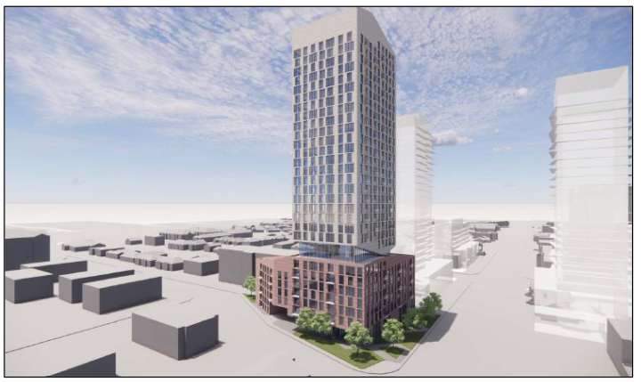
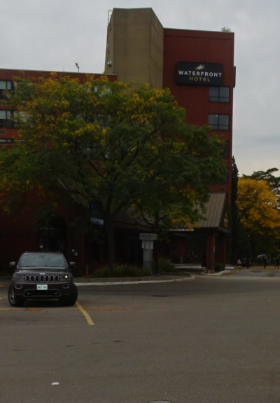
The public was recently treated to a pre-application presentation by Bousfields, the planning consultants hired by Vrancorp to re-develop the Waterfront Hotel site.
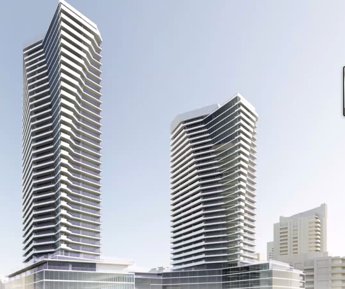
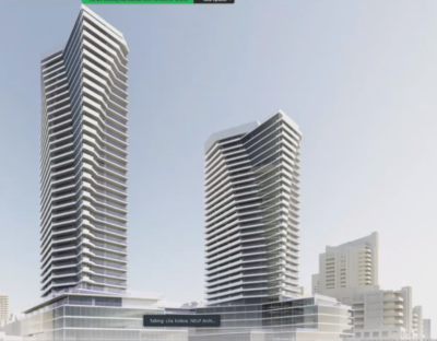
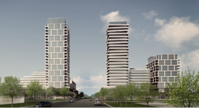
 The twin towers would change more than the skyline of the city. The designs that were made public were stunning – but much of the public reaction was less than enthusiastic – what stunned them was the idea of putting two towers on Lakeshore Road, one that would be the highest in the city.
Nice buildings but not in Spencer Smith Park, was the predominant comment.
The two towers were proposed for what the planners called the iconic ground zero location – the intersection of Brant and Lakeshore Road where a 35 storey and a 30 story tower were to replace the nine storey hotel.
The site has been the focus point for a lot of planning – some of it going back more than a decade.
An agreement had been put in place to have a study done on how best to develop the hotel site and have it compliment Spencer Smith Park and the Promenade.
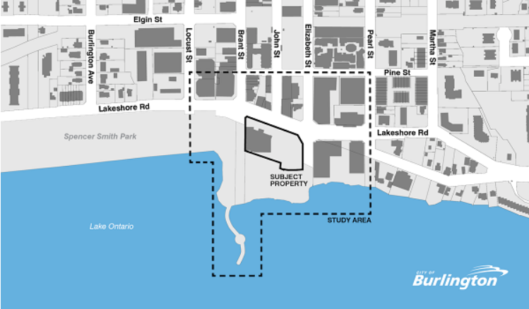 The area to be covered in the Waterfront Study that started back in 2005. At this point there isn’t a completion date – there is a report that is scheduled to go to Council in 1Q of 2022 Vrancor, the corporation that owns the hotel, is reported to have put up the $150,000 to have the study done. They are understandably upset. They paid for the study but the study was not completed. The city doesn’t have a planner assigned to the study – the most recent word is that the planning department will be getting something to council in 2022.
This may be one of those times when the horses are out of the barn and it’s too late to close the door.
In June 2018 Council went along with a revised Work Plan for the study that was to be completed by Q1 of 2019, (This was before Meed Ward became Mayor.)
The re-thinking of what could be done with the site goes back to 2005 with a follow up report in 2006.
There was a subsequent site-specific policy requiring that a planning study process be completed prior to any redevelopment of the subject site.
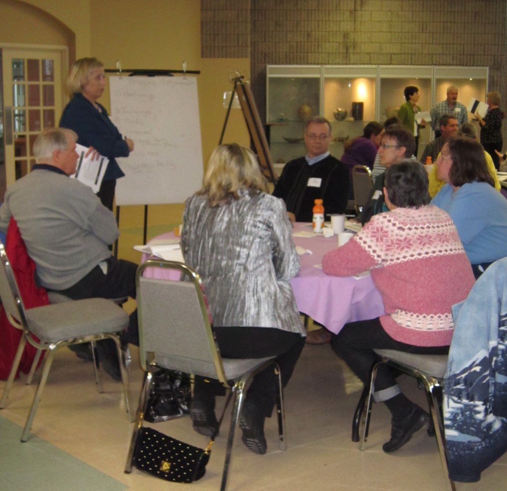
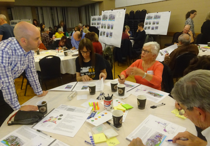 Residents at a workshop setting out their ideas with planner Thomas Walker. The 2018 report called for a high quality of urban design reflecting the landmark nature of this site, that “shall be contingent upon the completion of a master plan to the satisfaction of City Council.”
Public meeting to consider what the waterfront area should include.
In 2015 Council approved the terms of reference for the Waterfront Hotel Lands Planning Study.
In 2017 the Waterfront Hotel Planning Study was publicly launched, beginning with a pair of visioning workshops in May.
In November of 2018 the site’s significance was affirmed at the Planning and Development Committee meeting, evidenced by a number of delegations that presented a varied set of interests and development concepts.
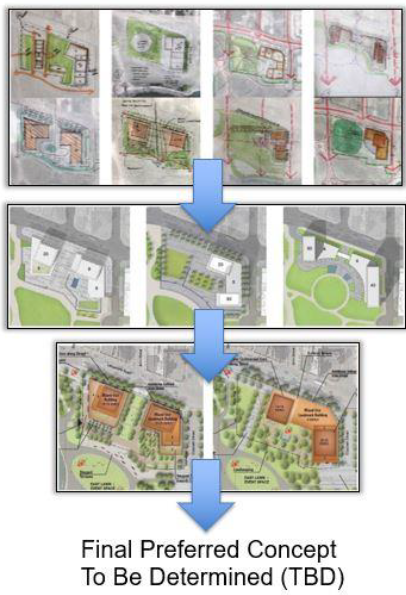 A series of drawings that got whittled down to two Preferred Concept – and that as far as the study of the Waterfront Hotel site has gone. At this point, 2018, the public had a series of drawings that resulted in two preferred concepts for development.
A group known as Plan B inserted itself into the process with their position that a thin red line be drawn beyond which there would be no development west of the hotel site.
Despite extensive engagement opportunities, a clear consensus on direction had not yet been achieved. Staff then built upon the consultation work done through three community workshops (a total of six sessions); what came out of the Planning and Development Committee held on November 28, 2017, and significant contributions from the Vrancor Group and the Plan B Citizen Group; they created key policy directions to move forward.
The key policy directions were intended to align with the vision statement, accommodate an iconic landmark building, and reinforce the site’s unique location as a major gateway to the waterfront.
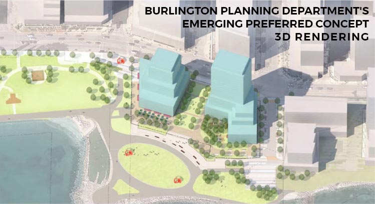 One of two renderings of what the site might look like. The entrance to the development would be from John Street not Brant
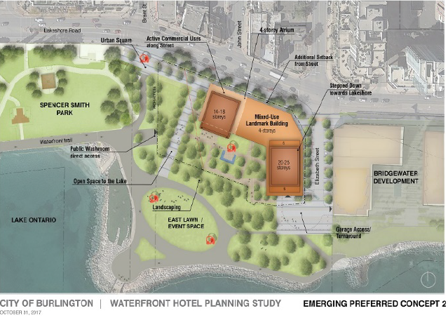 Early concept didn’t have the height that was shown in the pre-application presentation. The key policy directions have been organized around the study’s three frameworks and guiding design principles of Land Use and Built Form, Public Realm, and Mobility and Access, as follows: Land use and built form and Public Realm are important and it is vital that everyone share the same understanding as to just what this means.
Land Use and Built Form
1) Create building frontages along Lakeshore Road and Elizabeth Street with building placement that establishes a defining street wall and frames the street zone.
2) Provide active uses at grade along Lakeshore Road and Elizabeth Street.
3) Achieve active and animated edges adjacent to Spencer Smith Park, with a requirement for retail and service commercial uses at grade:
a. Built form next to the south property line shall activate and animate this edge, respect the existing grade, and be scaled to the waterfront trail with higher levels stepping back as necessary.
b. Built form next to the west property line shall activate and animate this edge, respect the existing grade, and be scaled to Spencer Smith Park with higher levels stepping back as necessary.
4) Require a minimum of two uses within buildings and where feasible, encourage three uses.
5) Establish an iconic landmark building on the site subject to the following:
a. A new public, pedestrian space is provided at the foot of Brant Street where public views to the Lake and Pier are enhanced;
b. The iconic landmark building must contain a destination use or function;
c. The iconic landmark building shall enhance the City of Burlington’s image/identity.
6) Require design excellence in all matters of architecture, landscape architecture, sustainable and urban design and require that all public and private development proposals on or adjacent to the site be evaluated/reviewed by the Burlington Urban Design Advisory Panel.
 An unobstructed view of the Pier from Brant Street was objective number 1 for almost everyone. Public Realm
7) Protect public view corridors to Lake Ontario from Brant and Elizabeth Streets, and where possible John Street.
8) Enhance the Brant Street view corridor to frame views to the Brant Street Pier, and require a significant building setback from the west property line.
9) Create new and enhanced publicly accessible green/open space, which would include new north-south pedestrian connections between Lakeshore Road and Spencer Smith Park (mid-block and along the site’s edges).
10) Minimize changes to the existing grade along the southern edge of the site and enhance the interface with Spencer Smith Park.
11) Integrate a public washroom within the future redevelopment; with an entrance that is accessible, highly visible and within close proximity to Spencer Smith Park.
12) Identify opportunities for the placement of public art on and adjacent to the site.
Staff was to continue with background work and in early 2019, re-start the process with a refreshed look and feel building on the above policy directions. This will include a revised work plan and new public engagement plan which leverages the city’s newest communication and engagement software and tools.
Changes to the existing land use designation and permitted building height are not included in the new Official Plan – as it was in the then current Official Plan – not the one that the new Council adopted in 2019.
The process would involve a site-specific amendment to the Official Plan at such time as the study is completed by the City and approved by City Council.
What muddies up a clear understanding was the existence then of a downtown mobility hub, that problem was resolved; then a change in the Urban Growth Centre boundary.
The ICBL – Interim Control By Law was imposed and then the world was hit with a pandemic brought about by the Covid19 virus.
We are now at the point where a sense or normality seems to be returning.
Add to that a frenetic increase in the development applications that required the city to hire more than a dozen new planners.
Then along comes the planner for the hotel site owner saying they were tired of waiting and did a pre-application presentation that shocked many.
That pre-application is the beginning of a process that has a ticking clock.
 The towers are closer than many realize – closer to the street than the hotel on the site. So back to that first question: which should come first – the completion of the Waterfront Study or the accepting of a development application.
There is an important connection between this Waterfront Study and the City’s new Official Plan, the Downtown Mobility Hub Area Specific Plan, the City’s Transportation Plan, Cycling Master Plan, Community Trails Strategy, the Transit Plan and the Tall Building and Downtown Streetscape Guidelines, all of which are necessary to ensure that redevelopment of the subject property meets the City’s urban design and growth management goals, as well as enhances the adjacent public space and waterfront.
People began asking – what about the Waterfront Hotel Study and wondering how a pre-application presentation could be done before the study was complete.
There is a lot riding on what is to be built on the hotel site; people are getting anxious.
Will the downtown core begin to look like the Toronto waterfront where a lot of the land south of the Gardner Expressway is studded with towers that limit the view of Lake Ontario?
Not much is being heard from the politicians – they have taken the view that they can’t say much at this point without being accused of being biased.
The point at which they feel they can comment is when planning staff produce their report that either recommends that a development proceed, or that the development not proceed or that they should continue working with the developer.
The stickler at this point is this: the city has 120 days to produce their report to council – something that is close to impossible for a development of this size.
Once the 120 point has been met the developer has the right to go to the Ontario Land Tribunal to ask for permission to proceed with the development.
Burlington has not done very well at the tribunal level, partly many feel because of the direction that comes out of Burlington’s legal department.
With all those agencies commenting the project begins to create some momentum that it might not be possible to hold in check.
The Gazette has made the telling of this story a mission.
The people of Burlington are going to have to make it a mission to ensure that Council hears what they think and feel.
In the next 13 months we are going to go through a provincial election and a municipal election. The strategy for those who care about where growth takes place and the kind of growth that takes place should be a mission as well.
Related news stories:
The pre-application presentation
Is there a different approach to how the site can be used? A land swap perhaps?

By Pepper Parr
October 25th, 2021
BURLINGTON, ON
Each member of Council finds their own way to meet with constituents.
 When she is on a roll – Kearns is a dangerous lady with a microphone. Lisa Kearns (ward 2) has the most active ward in the city, although the folks in Aldershot would differ with her on that.
She has broken the meeting mold that most members of Council are using and is now meeting with her constituents both virtually and live. She held her second hybrid meeting last week and found herself spending most of the two hours explaining what was happening on the development side of things.
It is hectic and it is complex.
Council decided recently to proceed with the hiring of about 15 additional planners who will be needed to cope with the development applications that have kept the planning department stretched to the limit.
 Councillor Kearns suggested she might take constituents on a walking tour of the developments in her ward. Kearns put together a map of where the development is taking place in her ward and the status of a number of those applications.
 Brant Street is on the right hand side and Prospect is on the left side. Prospect curves around the development. A pre-application from Camarro Developments for the proposed development at Brant and Prospect had already been appealed to the Ontario Land Tribunal – it has been there for some time.
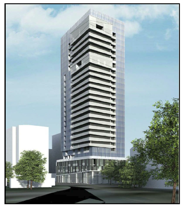
It took a number of questions to get the people giving the pre application presentation to say just how tall the building is going to be.
The plan is for 293 units with 275 parking spaces in the four underground parking levels. 61 – 3 bedroom; 100 – 2 bedroom, and 132 – 1 bedroom.
There will be retail at grade level. It wasn’t clear just what would be in the 7 level podium.
During their presentation last week we got some detail on what is going to be a 31 storey structure with a seven level podium with 25 storey’s on top of the podium – which sets a new record for height in the city.
 By Pepper Parr By Pepper Parr
October 20, 2021
BURLINGTON, ON
This Background piece is on the long side. It is the first time we have seen such a comprehensive engagement plan with so much detail and really relevant information. While we are surprised we also want to thank the Communications people for being this candid.
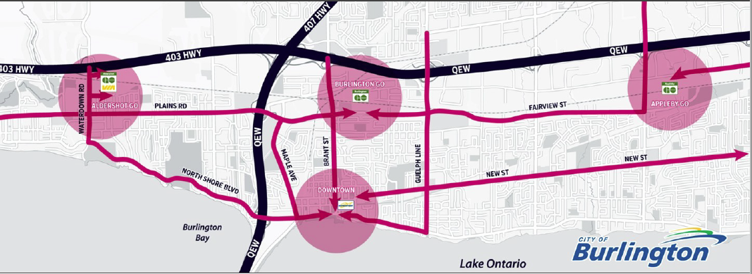
Burlington is in the next phase of city-building as it approaches full build-out of the urban area. The undertaking of area-specific plans (ASPs) for Burlington’s Major Transit Station Area (MTSA) represents the City’s continuing implementation of its vision for appropriate intensification and the protection of established neighbourhoods by focusing future population growth to key areas, and in particular, a focus around higher order transit.
 Way back in the beginning the GO stations were called Mobility Hubs and at that time the bus terminal in the downtown core was included a Hub. That mistake made it possible for a developer to put up a 26 storey tower which opened things up for other developers. This is a big big deal – it involves something in the order of 20,000 people and or jobs in what will be a small village of its own. It will take decades to get through it all and it may well change in some form going forward.
The city has put together an Engagement Plan – it runs 13 pages long – with a lot of surprising information.
Area Specific Plans for the properties within each MTSA have to be created.
This work started out as a Mobility Hub study which was placed on hold in Q1 2019 to allow for a shift in focus to emerging planning priorities, including the Region’s Municipal Comprehensive Review, the scoped re-examination of the adopted Official Plan and the Interim Control Bylaw Land Use Study.
There are a number of key differences that resulted in significant changes to the scope and considerations of the work that had to be done including the completion of all required technical studies, further public and stakeholder engagement and the completion of three (3) area-specific plans, as well as the associated implementing Official Plan and Zoning By-Law amendments and other implementation strategies which may be required to get everything before Council.
 Citizens will show up for a meeting if you make it interesting enough and promote it effectively. We will have to wait until we are out of Covid19 rules for events like this to take place The Engagement Plan highlights the points in the process at which engagement will take place, who will be engaged, and the level of engagement. The plan also clearly defines which aspects of the process the City and public can influence throughout the discussion.
Decision Statement
At the beginning of an engagement process, it is helpful to know, “what is the decision to be made?” A decision statement clearly identifies:
• what decision needs to be made;
• who is the decision maker; and
• when the decision is required.
The decision statement for the MTSA ASP project is as follows:
“By June 2022, Burlington City Council will vote to adopt amendments to the Burlington Official Plan, 2020 to incorporate Protected Major Transit Station Area (MTSAs) area-specific plans to guide development and investment around the Burlington, Appleby and Aldershot GO Station Areas.
“Amendments adopted by Burlington City Council will then be forwarded to the Region of Halton for approval.”
Summary of Stakeholders
A stakeholder is anyone who has an interest or concern about a specific topic. To identify the stakeholders for the MTSA ASP Project, a mapping process will be used to confirm all the people who are affected by this work, those who have influence or power over the work and those that have an interest in its outcome, based on the stakeholders previously identified through the Mobility Hubs Project. It is expected that various individuals and groups will be identified across the following categories:
• Residents and resident groups (including newcomers, young families and young people) • Community organizations; special interest, advocacy, and activism groups
• Government and public service providers (internal and external) • City Advisory Committees and arms-length city agencies
• Indigenous Communities • Development industry
• Businesses and business groups • Major facilities1 within or adjacent to study areas
• Private and non-profit community service providers • Elected officials
• Media
Once the stakeholders and interested or affected individuals and groups have been confirmed, the engagement milestones in this plan will be refined to reflect the tactics and level of engagement required for each party throughout the MTSA ASP Project.
Objectives of Engagement
The following objectives provide a clear understanding of what the public engagement will strive to achieve through the community discussion about the MTSA ASP Project:
• Provide relevant information about the project, decision-making process, and how the public can provide input and feedback;
• Work with City communications and engagement staff, as well as consultants, to provide a coordinated approach to engagement, communication and evaluation of the MTSA ASPs and their implementing policies.
• Provide multiple channels for people to provide meaningful input virtually and, if possible, in-person at appropriate decision points;
 The Getting Involved web site has loads of information and is the place documents are stored for quick retrieval. It takes some practice to get the hang of it all – but it works. • Create an ongoing record of what is said during engagement opportunities and make it available to the public throughout the process, so they can track the progress of the project, including reports back to the community that highlight how feedback was or was not incorporated into the final recommendations to Council;
• Gather meaningful input from members of the community whose voices are historically underrepresented in conversations about city issues;
• Establish a project page on getinvolvedburlington.ca as the main online platform for up-to-date information about the project and upcoming engagement opportunities;
• Use clear, plain language in the delivery of the Engagement Plan to inform the public about what can and cannot be influenced through the MTSA ASP Project.
Project Stages and Engagement Milestones
At a Special Meeting of Council on June 8, 2021, City Council [modified/endorsed] the work plan for the MTSA ASP Project. The key project stages and associated engagement milestones are presented below. For each project stage, the engagement plan identifies where public input will take place, who will be involved in the engagement and what level of engagement will occur.
The strategies that will be used for public involvement in the MTSA ASP Project reflect the feedback provided to the City in the May 17, 2021 Council Workshop. Relevant feedback from related projects has also been considered, including the new Burlington Official Plan, the Scoped Re-Examination of the Downtown and the Interim Control By-Law Land Use Study. These strategies will be further refined by the MTSA ASP Project Steering Committee.
Policies and Factors That Cannot be Influenced
In every public engagement process, it is important to be aware of the things that cannot be influenced: either because they are beyond the City’s control (for example things that are required by regional or provincial policy or law), or because they are outside the scope of the project as set out in the Council-approved work plan. In discussing the Major Transit Station Area (MTSA) Area-Specific Planning (ASP) Project, the following aspects are considered ‘givens’ and will not be included in engagement activities:
1. Planning policy at the local municipal level is informed by legislation, policies and plans such as the Planning Act, Provincial Policy Statement, Growth Plan, Halton Region Official Plan, Metrolinx Regional Transportation Plan and others.
2. City Council can adopt proposed amendments to the Burlington Official Plan, but Halton Region is the designated approval authority. Halton Region may modify City-proposed amendments prior to approval and, if appealed, the approved amendments may be subject to further change through the Local Planning Appeal Tribunal, (Now named the Ontario Land Tribunal) except for PMTSA policies and zoning regulations protected from appeal under the Planning Act.
3. The proposed Area-Specific Plans and associated implementing mechanisms will be prepared for the Burlington Official Plan (2020), not the Burlington Official Plan (1997).
4. This study is focused only on the Downtown Burlington Urban Growth Centre/Burlington GO MTSA, Aldershot GO MTSA and Appleby GO MTSA. MTSA boundaries and the corresponding minimum growth targets are being set by Region of Halton through its Municipal Comprehensive Review. Draft Halton Regional Official Plan Amendment (ROPA) 48 proposes updates to the Regional Structure and includes formal boundaries for each of the MTSAs within Halton Region. Once approved by the Province, these boundaries and targets cannot be appealed.
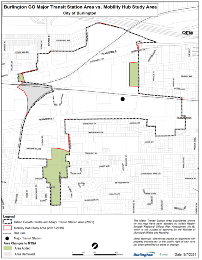 5. Urban Growth Centres (UGCs) are strategic growth areas that are planned for greater population and job growth and higher rates of development than other areas in the City and Region. Provincial policies set out minimum density targets for these areas, which are implemented through the Regional Official Plan, and then through the Burlington Official Plan. Draft ROPA 48 includes an adjusted boundary for the Burlington Urban Growth Centre (UGC). If approved by the Province, the adjusted UGC boundary will center around the Burlington GO Station Area. 5. Urban Growth Centres (UGCs) are strategic growth areas that are planned for greater population and job growth and higher rates of development than other areas in the City and Region. Provincial policies set out minimum density targets for these areas, which are implemented through the Regional Official Plan, and then through the Burlington Official Plan. Draft ROPA 48 includes an adjusted boundary for the Burlington Urban Growth Centre (UGC). If approved by the Province, the adjusted UGC boundary will center around the Burlington GO Station Area.
6. In 2017, a new policy framework for “Protected Major Transit Station Areas” (PMTSAs) was established in the Planning Act, R.S.O 1990. PMTSAs are a municipal tool used to support Higher Order Transit infrastructure around Major Transit Station Areas by establishing minimum density targets and transit-supportive land uses which are protected from appeal. In accordance with Planning Act section 16(16), once identified in an upper-tier municipal official plan and approved by the Province, PMTSA policies cannot be appealed.
Similarly, once implementing policies and zoning have been enacted at the lower-tier municipal level, the prescribed policies cannot be appealed.
PMTSAs may also require Inclusionary Zoning to support affordable housing objectives. Specifically, official plan policies may authorize Inclusionary Zoning by authorizing the inclusion of affordable housing units within buildings or projects containing other residential units, and by providing for the affordable housing units to be maintained as affordable housing units over time.
7. This project will refine and build upon the draft precinct plans developed through the former Mobility Hubs Study in 2018. However, as these plans were released as preliminary and were neither endorsed nor approved by City Council, they are subject to change based on further public engagement and the completion of technical studies.
8. Certain aspects of this project will be informed by the outcome of various technical studies, many of which are required by legislation and policy. These technical studies are undertaken in accordance with established criteria and completed by qualified experts.
9. The Burlington MTSAs are complex, previously developed areas with multiple landowners. The City does not have control over the speed of change related to development. Property owners decide when and if they will develop or redevelop their property.
10. The implementing Official Plan Amendments must be adopted by City Council by June 2022.
11. The implementing Zoning By-Law Amendments must be approved by City Council by December 2022.
 Kwab Ako-Adjei, Director, Corporate Communications & Engagement at City of Burlington, has set out a demanding criteria for evaluating the effectiveness of the Engagement Plan. Burlingtonians haven’t seen an approach like this before. How the City Will Collect and Respond to Feedback
Throughout the engagement process, City staff will diligently collect and record all input provided by stakeholders. All input will be recorded by theme into response tables, showing in detail how the comments were considered and how they did or did not shape the study process, the Area Specific Plan and their associated implementing Official Plan amendments recommended to Council, and why.
Evaluating the Engagement Process
Throughout the MTSA ASP Project, City staff will capture interim feedback on the engagement process through measures such as feedback/satisfaction surveys. This will allow for ongoing and incremental evaluation of engagement efforts and will support an iterative process where feedback may influence the engagement process throughout the project.
To assist in measuring how the public participation contributed to the final project decision to be made, the following will be used to evaluate the overall public participation process.
1. Once the project is complete, measure the degree to which community members felt they:
a. Understood the project’s process and its limitations
b. Understood how the feedback they provided influenced the outcome of the City Council approval.
2. Evaluate each form of engagement. How did each of the engagement approaches used help to achieve the engagement objectives?
3. Analyze how the feedback received about the forms of engagement informed new or alternative approaches to the overall public participation process as the project moved forward.
By Staff
October 21sr, 2021
BURLINGTON, ON
Another Brant Street development – this one at Brant and Prospect – 789-795 Brant Street
Applicant is
Camarro Developments Inc.
Described as having a seven level podium with a tower that will have 307 units – but no mention of the actual height. The paucity of information has the ward Councillor upset. The proposed development concept for redevelopment of the Subject Lands currently provides for a mixed-use development consisting of one residential tower containing 307 residential units, ground floor retail at the base of the tower. The application includes three ground-level townhome units integrated into the building. The proposed development will have a mix of 1-bedroom plus den, 2-bedroom, and 3-bedroom units.
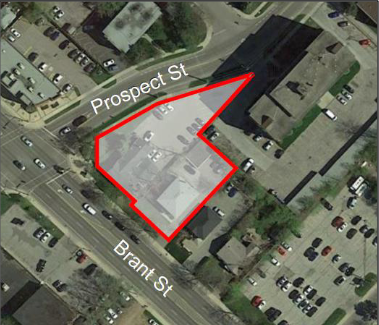 No mention of how high the building will go other than noting that the proposed development includes a podium with a height of 7 storeys facing Brant Street. The townhome built form, with frontage along Prospect Street, will reflect the building height of the neighbouring apartment development to the east. No mention of how high the building will go other than noting that the proposed development includes a podium with a height of 7 storeys facing Brant Street. The townhome built form, with frontage along Prospect Street, will reflect the building height of the neighbouring apartment development to the east.
The Preapplication presentation will take place this evening at 7:00 pm
Oct. 21, 2021, 7:00 – 9:00 p.m. (Virtual Meeting)
 By Pepper Parr By Pepper Parr
October 20th, 2021
BURLINGTON, ON
To get some sense as to where your ship is going – you want to know something about the person at the wheel and the decisions they make.
Same rule applies to the Mayor of Burlington.
There have been some very good decisions. The decision to have the Urban Growth Centre moved north was a good decision.
 A smart lawyer and a planning department that didn’t understand just what the concept of Mobility Hubs (now called MTSA’s) was all about. The Mayor was dead on about the bus station that was declared a Major Transit Service Area – as soon as she had all the information she saw the obvious.
The disturbing part of that was that the council that served from 2010 to 2018 neither knew or weren’t told by the planning department that the designation given that bus station was an error. Instead they left it in place and the result is the 26 storey Nautique that is now under construction.
Someone in Planning should be wearing that one.
Meed Ward understood the mood of the electorate and chose limiting development and making sure that the development that was coming was the right kind in the right place.
She basically chased the developers out of the downtown core.
Admittedly there are a number (about four with several pieces of land within the football that have not been dealt with) of development along Lakeshore Road and within the football that are a problem.
 Mayor Meed Ward does not appear to be ready to take a position on the re-development of the Waterfront Hotel site. Is this one of those “right things in the right place”? And of course there is the Waterfront Hotel development that could take the growth of the city as we know it today in a much different direction.
Perhaps it is time to think in terms of how Burlington could adapt to the change and make it work for them. We don’t see the city planning department getting in front of issues and being proactive.
The decisions in front of the Mayor now that are a concern are:
The Holiday market, which is now a done deal that got through Council under the shadiest of circumstances;
The park within the Molinaro development at Brant & Ghent;
The Waterfront Hotel site and the redevelopment of that property; and
her enthusiasm for the Holiday market scheduled for December 9th to 12. The Mayor buys into the claim that 1000 people will take part. What that market will do to the merchants in the downtown core who are struggling to stay above water is something they Mayor doesn’t seem prepared to take into account.
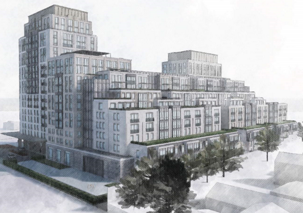
Very recently the Molinaro Group took part in a Statutory meeting in which they revealed their plans for a half acre park that would be created at the east end of the development at Brant and Ghent.
 Traffic for the towers on either side of Brant would exit and enter via Ghent. The half acre park is shown on the far right. Title to the land would be registered with the Condominium Corporation . The plan was to create the park, then turn it over to the condominium corporation that would eventually be set up to represent the interests of the condominium unit owners.
The idea that the unit owners will go along with their owning and maintaining a park that would be open to the public is a real stretch.
Anyone who has served on a condominium board would tell you that this is one of the craziest things they have ever heard of.
 This is described as a half acre part which was described as bringing some of Spencer Smith Park north The Mayor seems to think that the city would get another park at no cost and residents of a condominium will cover the costs of keeping it operational.
 Renderings on what a park could look like. Will the information about the park for which unit buyers will have to be clearly set out in the sales literature? Will it be clearly set out in the condominium agreement – those things run to several hundred pages which only the lawyers read.
The Mayor does not appear to have taken a position on the proposed redevelopment of the Waterfront Hotel site. One has to ask: Where is the claim that this Mayor wants the right development in the right place ?
 There was a time when Meed Ward was all about Truth to Power – now that she has the power Truth seems to have been mislaid. Growing from a really ballsy ward councillor who brought about some significant changes to the way the city operates, we appear to have a Mayor who has lost the wind she used to have in her sails.
She has pulled together a large part of her re-election team and she is in campaign mode.
 Ward 5 Councillor Paul Sharman – considering his options? And at this point there doesn’t appear to be anyone willing to run against her – except for Councillor Sharman who is probably considering his option.
Go for it Paul!
Salt with Pepper is the musings, reflections and opinions of the publisher of the Burlington Gazette, an online newspaper that was formed in 2010 and is a member of the National Newsmedia Council.
 By Pepper Parr By Pepper Parr
October 19th, 2021
BURLINGTON, ON
From time to time there are news stories that grow to something more than a one or two day event.
We have covered a few that were significant – and important.
The legal problems surrounding the pier: when a crane toppled and steel that bent much more than was expected was found to be below the required standard.
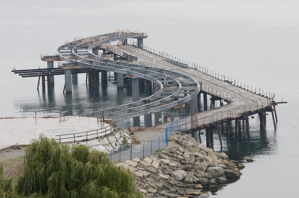 It was a Pier that was built twice – at double the cost The end result was the tearing apart of much of the first version of the Pier and starting all over at double the projected cost.
Another important event was the dumping of un-inspected land fill on the Burlington airport lands without the required permits.
We followed that story for three years, stayed strong during the libel suit that was filed against the Gazette and Vanessa Warren and Monte Dennis.
 Tonnes of landfill from unknown sources was dumped on the air park lands. It is still there ruining at least one property for which there was never any compensation. The libel suit was dropped but the land fill is still on the site – and the city is the poorer by half a million in legal fees.
Then there is decision on the part of Vrancor, owners of the Waterfront Hotel, who are expected to take the first required step to demolish the hotel and replace the 9 storey building with a 35 story tower and a 30 story tower that would sit atop a four storey tower.
There are those who like the idea; there are those who think it is a mistake. The Plan B group certainly think it is a mistake.
The design of the towers is striking – it would be nice to live in it – but the Gazette does not believe those towers should be built on the Waterfront Hotel site.
During the pre-application presentation both the Mayor and the ward Councillor were given the right to speak. Neither made comments for which they will be remembered.
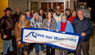
When first running for City Councillor Marianne Meed Ward was leading the Save our Waterfront Committee, demanding that the city not permit high rise towers anywhere near the lake.
 The waterfront is once again at risk Ten years later and all the Mayor had to say during the pre-application presentation was that the city had yet to receive an application. The first rule of stopping a development is to do everything possible to prevent it getting momentum.
If the Mayor is opposed to this development – and it this point we don’t know if she is or if she isn’t – saying nothing is not what the citizens of Burlington elected her for.
She was noisy noisy about Saving the Waterfront in 2010; she was noisy noisy when it came to pushing to get the Urban Growth Centre moved north and away from the Downtown Core in 2018.
She was close to mute when she had a chance to say something about two towers that would loom over Lakeshore Road if they are built.
The Gazette is of the view that few people fully understand what is taking place. There were less than 100 citizens participating in the virtual pre-application presentation.
In the two pictures set out below we try to give people an idea of what a 35 storey tower looks like when compared to what already exists on Lakeshore Road.
 The tower on the left is expected to be on the Brant Street side of the development. It is 39 storeys high, the Hotel is 9 storeys high which would make the development more than four times as high as the current structure. When set against what is currently the highest building in the city the difference is also very significant.
 The Waterfront hotel – stands 9 storeys high. 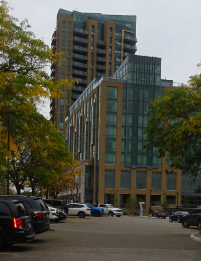 Bridgewater condominium, currently the tallest structure in the city. 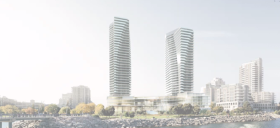 The tower on the right would be next to the Bridgewater development and at 30 storeys plus a four level podium come in at 35 storeys – one third higher than the Bridgewater condominium.
By Pepper Parr
October 18th, 2021
BURLINGTON, ON
Following the proceedings at an Ontario Land Tribunal hearing is not for the faint of heart.
It seems to take forever to get to the point where a hearing actually takes place.
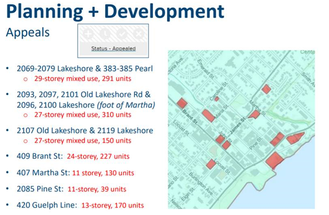
Actually getting to a hearing for development applications in Burlington is complicated by the fact that there are at times more than a dozen developers appealing a city decision or appealing for relief from the OLT because the city has not made a decision before the clock ran out.
Among the issues before the OLT at this time are the Interim Control By Law and the newest Official Plan that has been approved by City Council and Regional Council and awaits the signature of the Minister of Housing and Municipal Affairs after which it becomes the law of the land.
 Controversial from the very beginning, the long term care residence got caught up in the creation of an Interim Control Bylaw The ICBL was holding up all kinds of development including the AMICA project that will rise on the Northshore Road and the ramp to the QEW.
At the OLT Case Management Conference last Thursday the Commissioner agreed with the lawyers (there were 20+ of them on the call) that the ICBL could be lifted except for several properties along Fairview between Brant and Drury Lane.
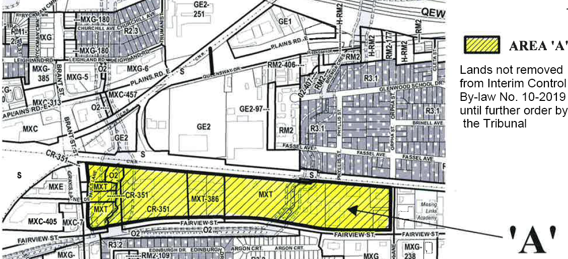 Some of the most valuable land in the city with some of the loosest zoning as well.
 By Staff By Staff
October 18th, 2021
BURLINGTON, ON
We start with the city of Burlington within which there is the village of Aldershot, within which there is now Aldershot Corners. The Corners has five precincts.
There is a Preliminary Vision for the Aldershot GO Major Transit Station Area, and Aldershot Corners – a community within a village.
Located minutes from Hamilton at the western edge of Burlington, Aldershot Corners is a visitor’s first impression of Burlington when travelling east from Hamilton and Niagara on the Lakeshore West GO line.
The area is nestled within the Aldershot Village Business Improvement Area and focused at the corners of Plains Road, Waterdown Road and Cooke Boulevard. Part of the Treaty 3 lands, Indigenous People were stewards of the land for thousands of years before settlers arrived. Post-Colonially, this area was a major hub for brick manufacturing, and also has a rich agricultural past rooted in fruit production.
Aldershot Corners will continue to evolve as an urban area with a distinct sense of neighbourhood character, supported by a mix of residential, commercial and employment uses.
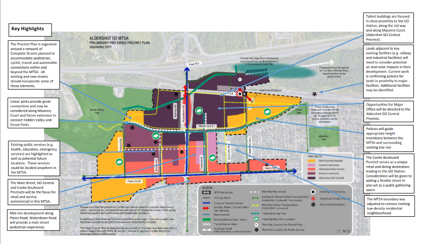
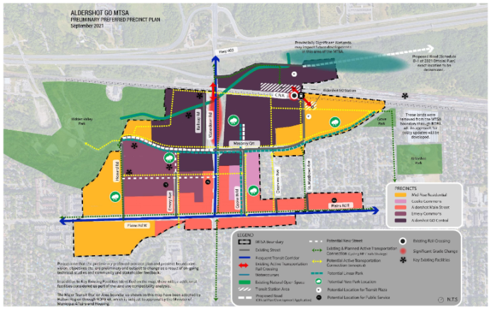 The colour coding sets out the precincts – detail elsewhere in this article explains what is planned for each of the precincts. Taller buildings will be concentrated along the rail line and will decrease in height and intensity closer to Plains Road and the existing residential neighborhoods.
Aldershot Corners will be a vibrant, livable community with urban shopping and dining opportunities serving those living and working close by.
New multi-modal urban streets and active transportation facilities will better connect the existing community, providing enhanced mobility and improved access to the GO Station, leisure and recreation opportunities in urban parks and open spaces, as well the many other amenities Aldershot already offers.
The planners created a number of precincts, which are boundaries within which specified levels of development are permitted.
There are five within the Aldershot Corners part of the Aldershot part of the city.
 Mid Rise Residential. Mid Rise Residential.
Compact residential communities, with a variety of low-rise and mid-rise building forms up to 11 storeys closer to main streets. This Precinct will provide housing forms at a lower scale and intensity including family oriented and ground oriented housing to support the creation of a wide range of housing options, including affordable housing.
Opportunities for commercial activities at street level on strategic streets may be permitted. Policies will guide appropriate transitions from low rise residential development to more intensive mixed uses. Policies will guide appropriate transitions from the maximum height (11 storeys) to adjacent low-rise neighbourhood, which may include angular planes, setbacks and/or stepbacks.
 Aldershot Main Street Aldershot Main Street
This Precinct will advance the Plains Road Village Vision and establish a unique community destination with a focus on a continuous retail frontage and main-street pedestrian experience along the frequent transit corridors (Waterdown Road and Plains Road E.) Policies will introduce a requirement for buildings to have a “lower building” design to create a pedestrian scaled environment at the street level. Policies will guide appropriate transition from the 11 storey maximum height to existing low-rise neighbourhoods, which may include angular planes, setbacks and/or stepbacks. Precinct lands that are adjacent to existing low rise neighbourhoods, will have a maximum height of 6 storeys. To ensure functional retail and commercial spaces are created, a wide range of approaches will be considered, including but not limited to establishing minimum floor height for the ground floor of buildings, and considering a minimum retail unit size. Opportunities for affordable housing will be considered in the Aldershot Main Precinct.
 Cooke Commons Cooke Commons
Serves as a unique retail and dining destination creating a comfortable and vibrant pedestrian environment with active uses at the street level and increased emphasis on pedestrian and multi-modal movement. A flexible street is being considered to provide opportunity for a community gathering space and potential to close for special events.
Mixed-use buildings throughout the Precinct contribute towards the creation of lively, vibrant and people-oriented places. Along the west side of the street, heights range up to 19 storeys maximum adjacent to the GO Central Precinct and up to 11 storeys maximum generally along Cooke Boulevard. On the east side, there will be up to 11 storeys maximum generally along Cooke Boulevard which gradually steps down to 6 storeys with appropriate transitions, which may include angular planes, setbacks and/or stepbacks, to the adjacent low-rise residential neighbourhood. Policies will introduce a requirement for buildings to include a “lower building” design to create a pedestrian scaled environment at the street level. Direction to support the function of these areas to accommodate loading and services and support a wide range of retail use will be investigated and imbedded in policy.
Opportunities for affordable housing will be considered in the Cooke Commons Precinct.
 Emery Commons Emery Commons
This precinct will accommodate a concentration of residential, retail, employment and commercial uses.
Opportunity exists for a higher concentration of high density residential due to its proximity to an existing public park, a potential new major public park and the GO Central precinct. Mixed-use buildings, of varying heights to a maximum of 19 storeys, contribute towards the creation of lively, vibrant and people-oriented places. Opportunities for affordable housing will be considered in the Emery Commons Precinct.
 Aldershot GO Central Aldershot GO Central
The preeminent destination for Major Office, affordable housing and urban format retail in this MTSA focusing the tallest buildings (maximum 30 stories) close to the GO station. Where Aldershot GO Central abuts Waterdown Road and Masonry Court policies will require pedestrian orientation development, including an emphasis enhanced public realm and enhanced spaces for waiting for transit. There is particular emphasis on the need to design a functional, safe and accessible transit plaza. Polices will ensure that the MTSA will accommodate a proportional mix of residential and employment opportunities and ensure that the Aldershot GO Central precinct will be planned to accommodate major office employment.
 This map provides additional detail on what is planned for the different parts of what is being called Aldershot Corners. What is it that is driving these changes?
KEY CHANGES – A number of things have changed since the Draft Precinct Plans were presented to the public and Burlington City Council in 2018. The following highlights the key changes that have been made or are being considered and the drivers for these changes.
Aldershot GO MTSA –
MTSA Designation and Boundary – Identified in Provincial Policy, the Regional Official Plan must first delineate and assign density targets to Major Transit Station Areas. Regional Official Plan Amendment (ROPA) 48 delineated the boundary for the Aldershot GO MTSA which identified the removal of existing parks (Hidden Valley Park, Grove Park and Aldershot Park), areas north of the rail line, and established neighbourhoods from the 2018 Aldershot GO Mobility Hub boundary.
Employment – Regional direction through Regional Official Plan Amendment 48 is to include employment within MTSAs. While Aldershot GO MTSA does not have an employment only precinct, Major Office employment type uses will be required in the Aldershot GO Precinct and it will be outlined through policy. Other employment types, such as retail, institutional and personal services is broadly encouraged throughout a number of the mixed-use precincts. Specific targets for Major Office will be established.
 Comments made by the developer suggested there would be some retail – a Starbucks Coffee shop – but no mention of a supermarket – something the ward Councillor is anxious to see. Retail – The Aldershot MTSA will provide two unique pedestrian focused retail experiences. The Aldershot Main Street Precinct provides ground floor retail with a main-street pedestrian experience. Policies will be considered for ground floor heights and minimum retail unit sizes to ensure functional spaces are provided. The Cooke Commons Precinct will serve as a unique retail and dining destination leading to the GO Station, with a focus on creating a comfortable and vibrant pedestrian environment with active uses at the street level and increased emphasis on pedestrian and multi-modal movement. In addition to those unique areas the opportunity to require, or in some cases encourage retail in every other precinct to support the day to day needs of existing and future residents.
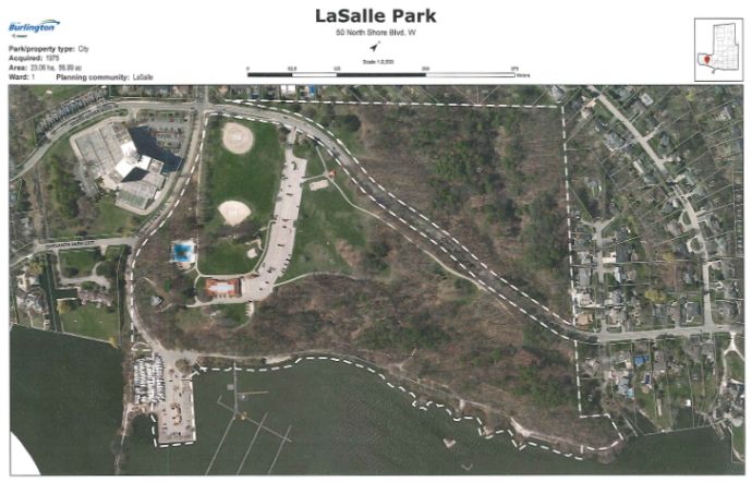 The only decent park is LaSalle Park; a 15 minute hike that will be stressed once all the residential development is completed. Great park with splash pads and a wading pool. Upgrades will be needed at some point. Public Parks and Linear Parks – As noted in the Provincial Policy Statement publicly accessible built and natural settings including parklands are important ways to promote healthy, active communities. Potential locations for parks are identified with a green tree symbol. The City is considering other opportunities for wider corridors along streets to act as linear parks to provide valuable open space/park space and facilitate connections. A linear park along Masonry Court connecting Hidden Valley Park with Grove Park will connect residents, employees and visitors to existing green spaces. A new linear park extending along Cooke Boulevard from Plains Road East to new development north of Masonry Court will focus on providing opportunities to linger and to support safe, comfortable pedestrian access to the station. Enhanced connections, linear parks, new parks and other connections are required throughout the MTSA in order to facilitate safe and more direct pedestrian and active transportation routes to and from the GO station.
Public Service – As noted in the Provincial Policy Statement, public services such as healthcare, education, emergency and protective services, cultural activities and civic administration are necessary to sustain healthy, liveable and safe communities. Key precincts will provide community spaces, alongside new residential and retail development in key locations. In addition to that new focus in key precincts the “PS” icon remains in key locations where the consideration of the incorporation of public service facilities is critical. Public services will be located strategically throughout the MTSA and policies will be developed to ensure that these services are located strategically to support population and employment growth in coordination will be coordinated with future development.
Integrated Mobility – In 2019, the City launched its Integrated Mobility Plan (IMP). This plan establishes a vision of safe, accessible, sustainable, balanced and livable mobility for the City of Burlington. The goals of this plan represent a shift from a focus on cars to more choice in transportation options; with a target of 20+% of trips in urban areas to shift towards transportation choices other than personal vehicles. A Transportation Assessment is being undertaken to identify the local street network for each MTSA (see technical studies below) which will integrate the vision and goals of the city-wide IMP.
 Newly built part of Station West – not much in the way of a complete street or parkland for that matter. Complete Streets (formerly referred to as Green Streets in the 2018 Draft Precinct Plans) – The City’s new Official Plan identifies the need for complete streets strategy for all future street and road projects (new construction, reconstruction, resurfacing and rehabilitation). The OP also states that MTSA primary and secondary connectors (Plains Road East and Waterdown Road) shall be complete streets. With a long-term view, the City is proposing that all existing and proposed streets in the MTSA allow for inclusion of some complete street elements over time which could include space for pedestrians, cyclists, transit, and streetscaping in addition to travel lanes for cars.
Active Transportation – The City is committed to implementing active transportation corridors to improve connections and transportation choice. Planned active transportation corridors have been updated to be consistent with the 2021 Cycling Master Plan and the 2015 Community Trails Strategy. Active transportation corridors and connections proposed through consultation are also shown in the MTSA.
Climate Change & Sustainability – The City’s Climate Action Plan establishes a net carbon neutral goal by 2050 for community emissions. Work continues to identify ways for the City of Burlington to address the impacts of climate change and reduce greenhouse gas emissions. In addition to the transit and active transportation focus of the Aldershot GO MTSA consideration will be given to other ways future development of this MTSA could address climate change including encourage building energy efficiency, urban design policies to address heat and tree cover, and opportunities to consider district energy.
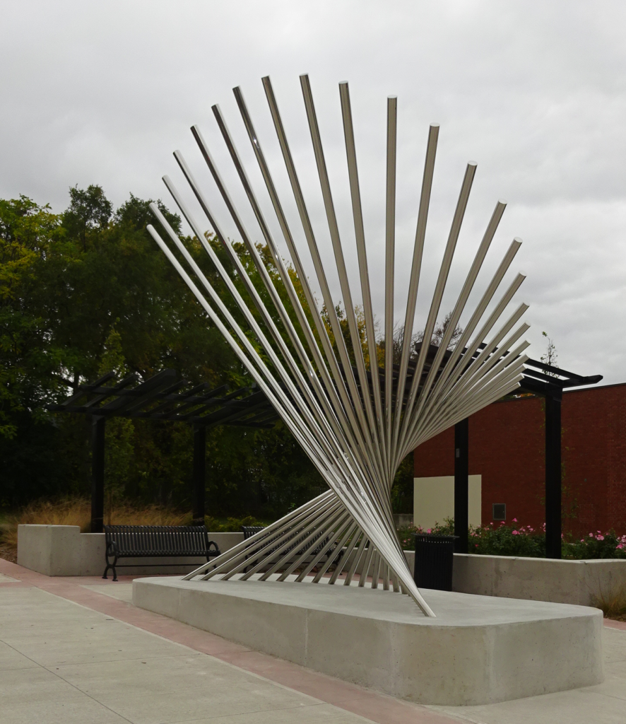 Public Art at the intersection of Waterdown and Plains Road Frequent Transit Corridors – Plains Road E. and Waterdown Road are identified as Frequent Transit Corridors in the City’s new Official Plan. Pedestrian-oriented development is desired along these corridors to support the frequent transit service. Policies will be identified to encourage pedestrian-oriented development along these corridors including consideration of lower heights at street level, urban design and public realm requirements. Urban design and public realm can also improve the experience for those waiting for transit along these corridors.
Technical Studies Underway – The following technical studies are currently being undertaken and may result in the need for further revision of the Precincts.
- Land Use Compatibility – There are some major facilities in and around the Aldershot MTSA which may require separation from sensitive land uses like residences, day care centres and education and health facilities. Work is being completed to confirm the potential for land use compatibility issues within the MTSA and to develop a framework for technical assessments to be completed as part of future development proposals. This work may result in changes to the precincts or area specific policies in the Plan to guide land use change and minimize the potential for land use compatibility issues over time.
- Transportation Assessment – The current Aldershot GO MTSA shows the planned South Service Road and Masonry Court as shown in the new Official Plan as well as the proposed new streets included in the 2018 Mobility Hub. Traffic congestion has been regularly raised as a concern by the public and a transportation assessment is being undertaken to determine the potential impact of adding the new people and jobs to this area. In keeping with the vision of the IMP, it is anticipated that the Transportation Assessment results will focus on non-auto infrastructure and ways to shift people to other transportation choices. One of the key outcomes of the Transportation Assessment will be to confirm the need and location for any new local streets to support safe, efficient movement throughout the area.
- Inclusionary Zoning – As part of the City’s Housing Strategy, an assessment of options to implement Inclusionary Zoning (IZ) is being undertaken. IZ is a tool to integrate affordable housing into future development. IZ can only be applied to MTSAs identified as protected by the Province and Regional Official Plan Amendment 48 which requires the City to establish affordable housing targets for its Major Transit Station Areas. Should IZ be recommended for Aldershot GO, there will be a need for the appropriate guidance on how the tool will be applied.
- Environmental & Hazard Lands –Studies are underway to identify areas that may be prone to flooding. Completed Flood studies for Aldershot are currently being reviewed by Conservation Halton. Identified areas may need to be protected through policies within some of the Aldershot GO MTSA Precincts. A Provincially Significant Wetland has been identified to the northeast of the MTSA and any potential policy requirements are being assessed through updates to an Environmental Impact Study being undertaken as part of the background technical work.
Heights and Transition – The maximum heights in the Aldershot GO Precincts generally remain as presented in 2018. There have been some minor changes including changing lands just east of Cooke Boulevard from Emery/Cooke Commons Precinct with a maximum height of 19 storeys to a new Cooke Common Precinct with a maximum height of 11 storeys. Policies will be included to guide transition from the maximum height, typically closer to the main streets, to lower rise buildings adjacent to existing low-rise neighbourhoods.
There will be an in depth look at the Plans for the Burlington GO station area on October 19th and a similar event for the area around the Appleby GO station on October 26th. On November 4th there will be a review of the plans for all three MTSA’s.
All will be virtual events.
There is a WORKBOOK for those who want to pass their views and opinions along to the planners. The link to the WORKBOOK is HERE
By Staff
October 18th, 2021
BURLINGTON, ON
Burlington has embarked on a huge city building project.
When completed the city will have three distinct neighbourhoods; the eastern part of the city will have a new neighbourhood centered on the Aldershot GO station.
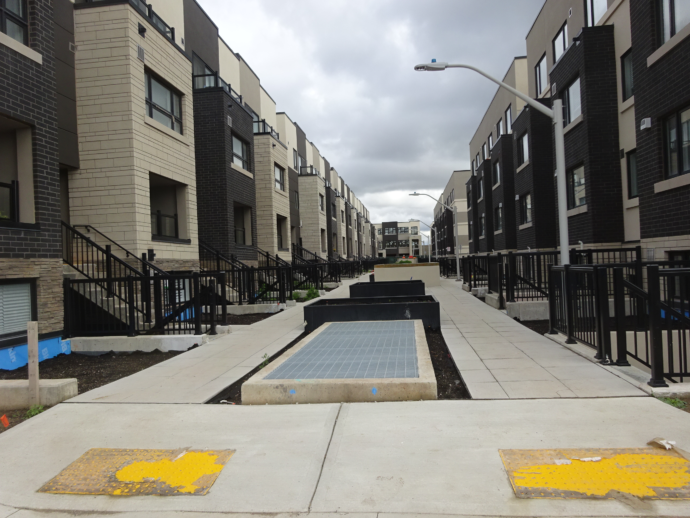
 This is the western boundary of the Station West Development built by the ADI Group. A significant part of the community building has already taken place in Aldershot. The Station West development by the Adi Group is well underway with three more towers to be built on the south west corner of the property that edges onto Masonry Road.
The other two new neighbourhoods will be centered on the Burlington and Appleby GO stations.
The city Planning Department is now working to get feedback from the people who will be impacted by these very significant changes.
A public meeting was held to explain what is planned. To get feedback from the public the Planners have devised a WORKBOOK that they say will take 30 to 45 minutes to complete.
Completing the WORKBOOK is voluntary and the information people provide is confidential (even to city staff).
The Planners recommend you complete the workbook on a laptop, tablet or PC to view the images in a larger format and keep a copy of the Preliminary Preferred Precinct Plan open in another tab or browser window to assist you in answering the questions and as a point of reference.
The link to the WORKBOOK is HERE. It is a little complicated. Just scroll through the pages, click on the images and then return to the page. There is enough instruction to get you through it.
The workbook is available in other languages. To request, e-mail getinvolved@burlington.ca. You may also use the “Select Language” translate button found on the project page to translate both the page and workbook.
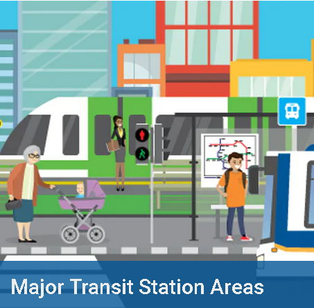
An MTSA (Major Transit Service Area) is the area within 500 to 800-metres of a higher order transit station (these are the three GO stations) that are expected to be about a 10-minute walk from the GO station.
These are seen as the three most critical locations within the urban area expected to accommodate the majority of the City’s forecasted growth to 2031 and beyond.
Through the preparation of the new Official Plan, new policies were developed to guide development and change in the Downtown and Uptown (at Appleby Line and Upper Middle Road). The MTSAs are now the remaining priority locations for which detailed planning must be completed to establish the vision for growth, to guide development, investments in transit, infrastructure and public service facilities, including parks, and to support significant future population and employment growth.
To some this project may feel familiar. From 2017 to 2019 the City worked on developing area-specific plans (ASPs) for the three GO Station areas, then called the Mobility Hubs Study. The MTSA ASP project will build upon, and advance, the work done through the Mobility Hubs Study.
The objective of this project is to plan to accommodate new residents and jobs by setting a vision for three unique, complete communities that are centered around the City’s three GO Stations along the Lakeshore West rail line. These communities will be environmentally friendly, infrastructure-efficient, walkable, bikeable, and will support local and regional transit with a diverse mix of employment, housing, recreation, and shopping features.
What have we heard so far?
Engagement was a key element of the previous Mobility Hub Study work. From the feedback received through 2017 and 2018, a number of key themes emerged to provide guidance in planning for these areas:
Increase, Improve and Support…
Public spaces by supporting existing and new open spaces, parks and other community spaces that are safe, usable, inclusive and interactive, and incorporate public art, landscape features etc. to enhance placemaking.
Community amenities by encouraging an increased scale and mix of commercial/retail uses at grade, including grocery stores, coffee shops, community and recreational space etc.
Mobility by designing a well-connected, safe and accessible public realm with active animated streets and robust cycling and pedestrian networks, focused on direct connections to and from GO Stations.
Housing options by planning for a diverse range of different and affordable housing choices to cater to all ages and abilities.
Private Spaces by encouraging sustainable design and variety of architectural styles to create distinct buildings and enhance neighbourhood character, and by reinforcing midrise corridors.
Public engagement by providing residents with enough time to engage and increase resident engagement and clearly explaining the required growth targets for Burlington.
Parkland by planning for park and public spaces that consider the needs of the entire area including developing fair approaches to meet that objective.
Traffic congestion by supporting the public transportation network and investing in additional facilities for walking and cycling.
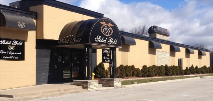 Solid Gold site as it exists today. Building height and transition concerns by clearly explaining planning rationale for where height is being located, ensuring and explaining how height will be regulated, and by reducing losses of sunlight and privacy through appropriate building height transitions.
 Speaking of height limitations – this rendering represents what the owners of Solid Gold want to build on a site that currently has a single story structure. Protect…
Established residential neighbourhoods by ensuring built form, height and transition support and respect existing character, and providing clear policies for heritage protection.
The planners learned that:
Beyond the broad themes highlighted above, a number of key themes specific to the Aldershot GO MTSA also emerged, including the consideration of:
– opportunities for new bike paths, including through Aldershot Park;
– opportunities for amenities to support residents and employees;
– opportunities for complete streets, including Cooke Boulevard;
– ways to manage the impacts of increased traffic along Plains Road;
– opportunities to incorporate mid-rise development along Plains Road and Waterdown Road; and
– excluding the low-density residential properties located on Clearview Avenue and a portion of St. Matthew’s Avenue.
A little more detail on what might go where Now the planners need your feedback. The input you provide may inform:
– Refinements to the vision (i.e. land uses, building heights, urban design considerations etc.);
– Precinct changes (i.e. policy directions, boundaries, built form directions, etc.);
– The preparation of the area-specific plans or the development of policy.
There are more specific details about all of the work that has informed the preliminary preferred precinct plan, including technical studies, can be found at getinvolvedburlington.ca/mtsa.
By Pepper Parr
October 14th, 2021
BURLINGTON, ON
The Molinaro Group spent years assembling the 13 properties at the Brant and Ghent intersection.
Now they are ready to develop.
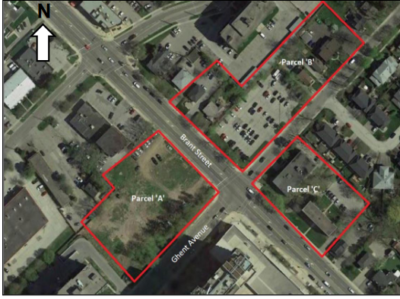 The proposed development spans three of the dour corners at Brant and Ghent They have broken the development into three sites which they refer to as Parcel 1, 2 and 3
It will be the biggest development the Molinaro’s have taken on in Burlington and will be, in their words, a Gateway to the downtown core.
 Looking south at the Brant – Ghent intersection The development does not fully comply with the in force Official Plan but does comply with the approved but not yet in force Official Plan.
The proposal is for a Multi-phase, mixed-use development, comprised of a 25-storey tower and a 14-storey tower 425 residential units in Parcel A;
a 25-storey tower (328 residential units) in Parcel B and an
8-storey mid-rise building with 128 residential units in Parcel C.
Ground floor commercial area is proposed for Parcel A and B. Underground parking (including bicycle parking) and limited surface parking area is proposed.
None of the traffic will exit onto Brant – the intention is to have the traffic exit and enter from Ghent.
The design is considerable different than what the public was shown during a pre-application earlier in the year.
At that time the two towers on either side of Brant were mirrors of each other. It looked good at the time but the architects took a different approach at the Statutory meeting.
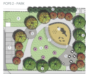
 A park is proposed for the east end of the the development. The park would be owned by the Condominium Corporation that would be formed when the development is complete. One of the most interesting aspects of the development was the inclusion of a park on the east end of Parcel 2. The park was to be a Privately owned with Public Access Space, known in the planning world as a POPS.
The really interesting comment that came from Ed Fothergill, planning consultant for the Molinaro Group was that the park would be owned by the Condominium Corporation.
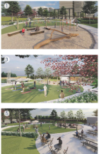 Some renderings of what the park night look like – it would be accessible to anyone in the city. To imagine that a condominium corporation is going to operate and maintain space that is open to the public is a stretch.
There were a few delegations. The one delivered by Jeff Bienhaus didn’t pull any punches. Working from a document he called: Stick With the Plan Burlington, Bienhaus said the plan should be dismissed.
 In a document that was included in his delegation Bienhaus wrote: “I would appreciate the support of our council to STICK TO THE PLAN of development as it was originally presented at the corners of “Brant and Ghent” with low rise development. The low rise is in keeping with our community and neighbourhoods in check with healthy growth and minimizing traffic congestion, noise and density. In a document that was included in his delegation Bienhaus wrote: “I would appreciate the support of our council to STICK TO THE PLAN of development as it was originally presented at the corners of “Brant and Ghent” with low rise development. The low rise is in keeping with our community and neighbourhoods in check with healthy growth and minimizing traffic congestion, noise and density.
I am opposed to the requested changes that are being proposed by the developer in
building 25 storey towers. This pace of building is overwhelming for this already busy
area.
I do hope that Mayor’s Meed-Ward original platform that she ran in stopping the
density will be kept and she does stand up for us …. PLEASE STICK TO THE PLAN

Pointing to the 2018 election results Bienhaus said the people he is working with want:
A clear message on what Burlington thinks about developer lead densification
A clear message that the Official plan for densification was not in the interests of residents.
A clear message that residents not developers will say how provincial targets will be met.
He added:
This is not what existing residents signed up for
Proposed 25 story ask is not even close to the current zoning of 2.5 and 6 story zoning
Extreme heights are not justified
Developers win, residents lose, who do you represent?
And closed with:
We call for a complete and full dismissal of this ridiculous zoning proposal on these and other grounds shared by similarly concerned residents
The Mayor didn’t offer much in the way of clear statements other than pointing out that the development proposed did comply with the approved but not yet in force Official Plan.
By Staff
October 12th, 2021
BURLINGTON, ON
The Burlington you know today is going to be a lot different in a decade – the major development will take place around the GO Stations.
 Concept drawing for the development proposed on Fairview at Drury Lane – next to the Burlington GO station The City of Burlington is continuing to seek input from the community about the Aldershot, Appleby and Burlington GO Major Transit Station Areas (MTSAs) through upcoming virtual meetings hosted by City planning staff.
The City is developing Area-Specific Plans (ASPs) for Burlington’s three Major Transit Station Areas to create a vision for future growth. The goal is to build complete communities close to transit, services and amenities by locating more people and jobs within about a ten-minute walk of the GO stations.
This will allow more people to live, connect, work and play in Burlington’s existing urban area, while protecting the city’s natural heritage and agricultural systems from urban expansion. The focus on development near transit will also help the City respond to climate change by providing more sustainable options for travel.
Building on work that was started with the Mobility Hubs Study in 2017-19, preliminary preferred precinct plans, policy and zoning directions for Burlington’s MTSAs have been developed for public input. Public feedback, findings from technical studies, and planning analysis will be used to develop recommended preferred precinct plans for endorsement by City council.
Once endorsed, the preferred precinct plans will be used to develop Area-Specific Plans (ASPs), which will define the City’s vision for guiding future development in the MTSAs based on land use, building heights and urban design considerations. Once approved by Halton Region, the ASPs will be implemented through the City’s Official Plan and Zoning By-law.
Residents and stakeholders can attend one or all four virtual Public Information Centres to get more information and learn about the project:
- Aldershot GO MTSA
Wednesday, Oct. 13, 2021, 7 to 9 p.m.
- Burlington GO MTSA
Tuesday, Oct. 19, 2021, 7 to 9 p.m.
- Appleby GO MTSA
Tuesday, Oct. 26, 2021, 7 to 9 p.m.
- All MTSAs
Tuesday, Nov. 2, 2021, 7 to 9 p.m.
The survey will close in the near future Zoom links and call in numbers to join the meetings, visit getinvolvedburlington.ca/mtsa.
This page also contains project Background Report and detailed study area boundary maps, an online workbook to share feedback and an option to subscribe for project updates. Residents can connect with MTSA staff at mtsa@burlington.ca or 905-335-7642.
Heather MacDonald, Executive Director of Community Planning, Regulation and Mobility said: “Burlington is in a new phase of city-building with future growth occurring mainly through intensification within the existing urban area. We are reaching out to residents to hear their thoughts on Area-Specific Plans (ASPs) for our city’s three Major Transit Station Areas (MTSAs) while we work to prepare them. This feedback is integral to create a vision for future growth with complete communities close to GO Stations. We want more people to be able to live, connect, work and play in Burlington, while making sure we protect the city’s natural heritage and agricultural systems from urban expansion.”
Links and Resources
getinvolvedburlington.ca/mtsa
By Pepper Parr
October 11th, 2021
BURLINGTON, ON
Jeremy Tellier is one of the more entertaining members of the Planning Department in Burlington. That isn’t to suggest there is no depth to the man – he has his facts down solid and understands the short, intermediate and long term impact of decisions that are being made. His client relationship skills are second to none. It is his delivery that makes him special.
 Thus it was one day last week that Jeremy was taking Council through an ask to hire more than a dozen new staff members for the planning department. Thus it was one day last week that Jeremy was taking Council through an ask to hire more than a dozen new staff members for the planning department.
The budget impact? None basically.
Tellier set the scene when he put up a graphic that set out what the city is heading into.
 Jamie Tellier started his Staff report to Council last week with a stunner of a document. “The technical issues and complexities are beyond anything that we’ve seen before, and that leads to increased time and effort to process those applications” said Tellier.
“I apologize for repeating myself because I know you’ve heard it before, but I’m gonna say it again, greenfield development is effectively over, our growth is going to occur from within, through intensification.”
The delivery of development services, depends on people power; … “the report before you lists the services that are needed to increase our capacity in critical areas, and enable staff to meet the legislative timelines that we have to deal with, as well as deliver on Council’s Land Use objectives and customer experience expectations.
We were already taking into account phasing and timelines of major projects, we really tried to just focus on those projects that we’re likely to obtain building permits in the short term. “What we’re going to do is take a more granular look at the extent of development that is in the planning pipeline, regardless of phasing and timelines. We think this is everything that we’ve got,
 “This is a slide that’s gives you the snapshot of all the development activity in the planning pipeline for active major applications for residential development. Site plan applications that have not yet been received, meaning they are in pre-consultation or about to come in for pre- consultation. You can see site plans that are currently in the review process. “This is a slide that’s gives you the snapshot of all the development activity in the planning pipeline for active major applications for residential development. Site plan applications that have not yet been received, meaning they are in pre-consultation or about to come in for pre- consultation. You can see site plans that are currently in the review process.
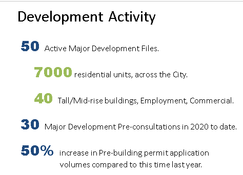
All in all we have 47 active applications in the planning pipeline that amount to approximately 19,100 residential units.
Now the table on the bottom we broke up that total units into building typology just to help understand some of the distribution.
We don’t expect 19,100 units to be built in the next couple of years, this, is everything we know of that is in our planning pipeline at various, various stages of planning approvals, we expect to spend the next decade on this working from a true planning and building to occupancy perspective.
This is easily a decade of construction activity in the city.
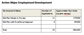 This slide is a snapshot of the planning pipeline for active major applications for employment development. the point of this slide is to show that more jobs are coming to Burlington. This slide is a snapshot of the planning pipeline for active major applications for employment development. the point of this slide is to show that more jobs are coming to Burlington.
None of this work has even made its way into building permits yet.
This slide shows building permit activity and construction costs over the past few years. The number of permits issued is still less than what we’ve seen in previous years. While we may have less applications coming in than we’ve seen in previous years. They are increasingly large and complex, hence these high construction values that you’re seeing on a chart, and this is a great reflection of the capacity issues that we’re experiencing across all of development services.
 The previous slides were just the planning pipeline, none of that has made its way into building permits and none of that is even reflected in these charts because this is just what what is happening right now on the building permit side of things. The previous slides were just the planning pipeline, none of that has made its way into building permits and none of that is even reflected in these charts because this is just what what is happening right now on the building permit side of things.
Staff anticipate this sustained development activity is going to require the following needed staff positions:
- Community Planning:
- (1) Coordinator of Business Services and Committee of Adjustment
- (1) Coordinator of Urban Design and Special Projects
- (1) Zoning Reviewer
- (3) Planner II
- (2) Senior Planners
- Engineering Services:
- (2) Senior Technician (Site Engineering)
- Transportation Services:
- (1) Supervisor of Planning (Transportation Planning)
- Building Permit Services:
- (2) Policy & Regulatory Services Clerks
- (1) Policy & Regulatory Services Supervisor
- (1) Building Permit Technologist
- (1) Coordinator of Building Permits (reallocated)
- (2) Senior Building Inspectors (reallocated)
Should Council approve the recommendation of this report, it is expected that all positions will be immediately posted for recruitment with a priority for Engineering Services to resolve urgent capacity issues on the Site Engineering team. It is noted that the Engineering Services Department intends to use consulting services in the interim to address the capacity issues in Site Engineering until the recruitment is complete.
To ensure cost recovery for development services, a planning application fee review is currently underway; we’re targeting completion by the end of this year. The last time we did this type of deep dive into our planning fees, was in 2012.
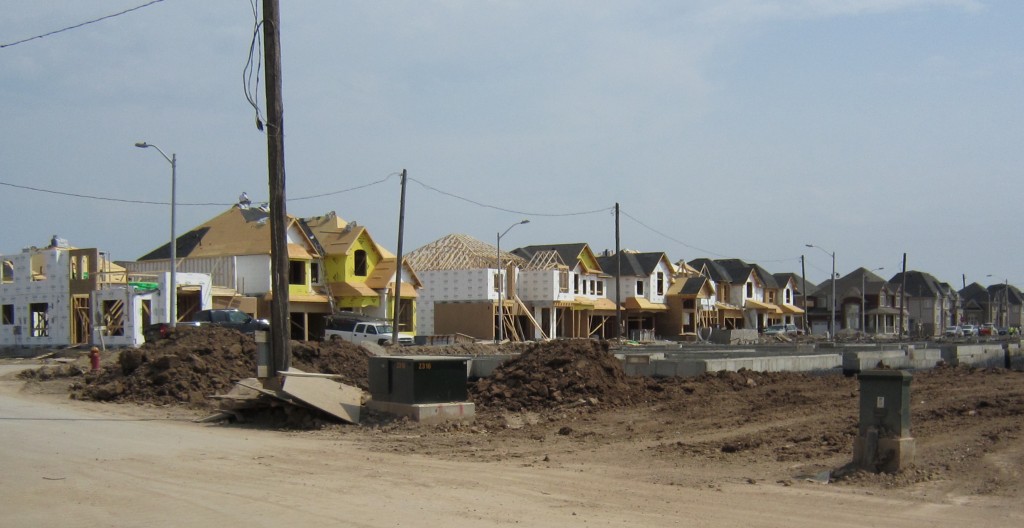 This was one of the last greenfield developments in the city. There isn’t any more space in the Urban Boundary which is basically at Dundas Street Burlington has effectively built out to its edges, we now have to grow from within, and development is almost entirely in an infill context and development applications and an infill context are increasingly complex and require more staff effort, which then affects our cost to deliver our services. So full cost recovery for development services is critical for long term fiscal sustainability. In other words, we need to minimize our dependence on the tax base for the operating costs of development services.
Tellier used a couple of case studies to help understand the order of magnitude of revenues and fees that get collected through development services.
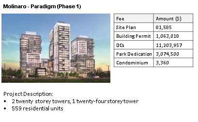 “On the Molinaro property, the phase one development, consisted of two 20 storey towers and one 24 storey tower with 559 residential units. When you look at the table on the slide, what’s interesting is this development only required site plan approval. “On the Molinaro property, the phase one development, consisted of two 20 storey towers and one 24 storey tower with 559 residential units. When you look at the table on the slide, what’s interesting is this development only required site plan approval.
“And you can see if we were processing the site plan under our current fee schedule like as of today, the fees would would come out to a little over $81,000 Just for the site plan application, and then the three building permits for the three towers – those permits worked out to over a million dollars in building permit revenues. Development Charges worked out to over $11 million, and in development charges Park dedication – over $3 million. And then lastly, the condominium application, a little over $3,000.
 “Here’s another example of a Carriage Gate Berkeley Medical One development this project consists of a 17 storey tower with 120 residential units, an eight storey office building, with a little over 10,000 square meters of retail and office area, a six story parking garage with 226 parking spaces. There are some section 37 benefits as a result of the rezoning. This development did require an official plan amendment and Zoning Bylaw Amendment – if we were processing this today, you would see the fees would be over $109,000 in revenues, just for the Official Plan and Zoning Bylaw Amendment. And then you can see for site plan that if we were receiving that application and processing that today it would be a little over $43,000. What’s interesting here is the only part of this development, the apartment building, has been constructed. The parking garage, and the office building have not yet come in for building permits, and so that’s reflected in the building permit fees of $314,000, which have been collected, “Here’s another example of a Carriage Gate Berkeley Medical One development this project consists of a 17 storey tower with 120 residential units, an eight storey office building, with a little over 10,000 square meters of retail and office area, a six story parking garage with 226 parking spaces. There are some section 37 benefits as a result of the rezoning. This development did require an official plan amendment and Zoning Bylaw Amendment – if we were processing this today, you would see the fees would be over $109,000 in revenues, just for the Official Plan and Zoning Bylaw Amendment. And then you can see for site plan that if we were receiving that application and processing that today it would be a little over $43,000. What’s interesting here is the only part of this development, the apartment building, has been constructed. The parking garage, and the office building have not yet come in for building permits, and so that’s reflected in the building permit fees of $314,000, which have been collected,
“Same thing with development charges, a little over $2 million, and park dedication that’s $660,000, and the condominium application – a little over $3,000. The Official Plan Amendment and the site plan approval approved the entire development so the developer doesn’t need to come back to planning, if they wish to build what was previously approved on that site.
“In order to handle this flood of development application and stay within the time frames the planners have to work with everything is dependent on improving staff capacity across development services.”
That concluded the Staff presentation; it was on to questions from Council members.
 Ward 5 Councillor Paul Sharman Councillor Sharman was the first out the gate saying “You know, I’ve been trying to figure out how many applications we have in the pipeline, for a few years. We used to have a monthly development activity report by ward that was extremely insightful, we stopped doing that now my assumption was we stopped doing that because we had similar information on the Planning and Development website under development, or applications by ward… can we please get back to having a report?
Sharman added that “we also need the operations review meeting every month. What can we do to get that information, please?
Mark Simione responded: “Yes, we’re absolutely in agreement someone will provide that information. It’s simply a matter of acquiring the data that’s repeatable, verifiable and accurate. There’s no disagreement from staff we completely agree that this is a worthwhile project.
 Councillor Bentivegna had a question around the “new staff that we need for the next phase of our growth. I think the numbers when you add them up come to $1,000,007 per year needed to carry on. And from your case study, numbers, just using the Molinaro project on Fairview we’re looking at $15 million in terms of revenues from that one project. Councillor Bentivegna had a question around the “new staff that we need for the next phase of our growth. I think the numbers when you add them up come to $1,000,007 per year needed to carry on. And from your case study, numbers, just using the Molinaro project on Fairview we’re looking at $15 million in terms of revenues from that one project.
“Are those dollars we’re receiving as part of the permit fees, will they be distributed to some of those departments or how are we going to deal with those extra expenses. If they’re not included into this, and maybe the city managers are willing to answer that or someone in financing. That’s my first question.
City Manager Tim Commisso spoke: I’ll be real brief. It’s of significant concern in terms of making sure that all the departments have the capacity so the reality is, that we are limited in terms of what we can collect fees for – I just want to acknowledge that that is on our radar.
Tellier added: “First and foremost is to recover the direct costs for development services, but understanding that there’s so much support from other departments, those indirect supports and development services from the departments I had mentioned in my presentation and I think they’re also identified in the staff report.
 Ward 2 Councillor Lisa Kearns Councillor Kearns asked if: “This readjustment of the organizational design is based on what’s coming down the pipe, in terms of the mega projects for all intents and purposes. What about the smaller projects. The, you know, the trending areas in our city where it’s a knock down and build one home. The permits and so on. We’re doing this to speed up this service to improve the quality of the service all of all of the right things. When will we see the effects of increased or reduced times to get things approved, both for large operations, and for the little person who’s redoing their home, because right now it’s stressful. These are the sort of emails we’re getting at this point where it’s taken quite a long time, so can we comment on that please?
Heather MacDonald explained: “We’re not just looking at the big projects, we are definitely looking at infill projects as well, which are very complicated, often what I find more complicated than in dealing with Greenfield applications, because they are in established areas, and we are, you know, concerned about impact on the surrounding area. And also, sometimes dealing with applicants that are not the big developers are experienced developers so they that requires a lot more time and effort to work through the process.
“We have been through a couple of the pain points in the process for smaller applications, those being forestry and zoning, and in those two areas we’ve seen great improvement in how quickly we can process a couple of other pain points in the process that we need to, to address more fully, one being site engineering and that is definitely in this recommendation before you today for assistance in that area.”
You may recall, explained Tellier “that the first couple milestones was just trying to establish the structure and some stability in our department, we had a lot of staff that we had contracts upon contracts; it was a structure that didn’t quite align with the type of established work that occurs in established neighborhoods.
“We’ve reorganized the department into teams. We’ve re-arranged our structure and created stability. Now we’re at that third milestone of improving our capacity.
“That’s where we’re gonna start seeing the difference across all of development services exactly as Heather mentioned, when we think about forestry and site engineering and zoning and all the work to date that they do. In addition to that as we start thinking about the ability for us to work with our IT department so we can start improving our technology and our customer portals to empower customers, we’ll find some efficiencies there to help our customers succeed beyond what we can do right now.
“This is self financed within the system.”
Councillor Kearns had a final question: ” I just want to understand how we are working in two parallel tracks between designing and evolving the organization and then working within the actual budget process that does allocate FTP, some of which are revenue supported from tax and some of which are supported through the tax base.
“I’m just looking for that differentiation because what I’m not quite seeing now, and I’ll ask staff this separately is there an additional service level that’s being met, or is this to satisfy baseline so first? Why, designing and evolving the organization and not budget, and second baseline versus enhanced service.
Treasurer Joan Ford responded: “It’s all one. For purposes of this report there was a sense of urgency to try to get this in place. You are responsible for approving staff complement. So the HR positions, the complement falls with you. You can do it either at budget time or you can do it at any time .
“As has been indicated these positions are fee funded. And so, what we would do is we would include the HR costs in the budget, and we would increase the revenues to support those staff that have been approved. Once you approve this report.
“With anything there is risk. And one of the risks, is that the revenues may not be there in a given year to support the staff. We do have a reserve fund for both development application processing and building permit fees. As long as the revenues are there to sustain it. There shouldn’t need to be a huge draw from the reserve funds, but it is there, should we need it.”
Asked to move the report Councillor Kearns had one more question. “… back to planning staff and does this simply support baseline operations to meet all of the Key Performance Indicators (KPI’s) that are in place, or is this providing an elevated level of service?
The answer was: “This will assist us in meeting legislated timelines that we are required to meet, and also to better meet customer expectations. This will also position us to be able to handle the increased activity that we expect. So it’s both. Really, we need the assistance and the increased capacity right now.”
Kearns again: “I do have a third question. I’m just wondering if it’s possible to put together a bit of a media release or a news release. I can say that my office has been inundated with requests around permit processing times, things of that nature and I’d like to have something available to respond to our community members that have reached out, letting them know that we’ve made this really insightful analysis and carried through with the request of staff to increase a compliment from, you know, what should be a revenue neutral perspective, and if not, we do have a backup plan through those reserves. Just wondering if it’s possible to have a bit of a communication put together for internal and external use.”
City Manager Commisso assured Kearns that they will work with communications and get something out – following Council.
Mayor Meed Ward closed adding: “Let’s get on with processing the applications, everyone wants to be in Burlington and why not, it’s the best city in the country, in the world, and you have a lot of work ahead of you, so we obviously need to help resource you to do that well and happy to do that.
“I’d say this is really critical to everybody. Like everybody on council we’ve all been getting emails and phone calls and, you know anxiety over timelines that have extended for sometimes many many many months. This is really important. Any comments I’d leave with you were similar to the ones I left at the budget meetings the last two weeks. That is with respect to new software, and improving processes, and recognizing the new software by definition requires us to redesign our processes. And the question is how quickly can we get into all that? My last comment is remember the Customer.
 Councillor Galbraith ward 1 Councillor Galbraith: “I’ll be quick. This is great. Anytime that we have revenue funded positions, I want to see it as soon as possible. I didn’t mention this, going back last year that if there’s a streamlined process for this, to bring it through us faster even, you know, skip some of the typical reporting cycles. I’m in for that, In principle, so perhaps that’s something that Sheila might be able to think about if that would be feasible or the planning team. And the other thing that I see from this report is how we are certainly open for business in Burlington construction value forecasted is going back up to new heights, and I’m good with that – it’s going to help the city. Overall, obviously we are shaping that growth as a council. So, thank you very much for the report very well prepared and looking forward to having the positions.”
 Ward 3 Councillor Rory Nisan Councillor Nisan added: “I just have a couple of comments as well. I’m very happy to see this report and obviously funded positions are much easier decision for council to to make, I know my office has certainly been inundated. There is a lot of construction activity at the moment, and projects that are in the engineering department and all departments within the city and I would like to receive less calls if I can, so happy to see that there will be more positions. I don’t think the construction activity is going to be less than any in the future. I think this is the right decision and the fact that it doesn’t require budget decisions is, a fairly easy one for me to make.
Counselor Kearns then commented: “Just a quick one and I just want to highlight that what we’re doing here is also improving safety within our community. The building department is responsible for all of those inspections to make sure that the Building Code inspections are carried out to the highest regard. I really look forward to getting this compliment up to full whack because we don’t want to miss those timelines and we want to make sure that we give that very very high level customer service.”
And that was it – no more questions; no more comments. The Chair called the vote – it carried and goes to Council on the 19th where it will be approved.
By Pepper Parr
October 9th, 2021
BURLINGTON, ON
The pre-application presentation, that the city planning department requires of a developer before they submit an application, was put on by the owners of the Waterfront Hotel on September 8th. It was a virtual event.
There were something in the order of 125 people, many of them members of Council and staff as well as other developers and members of the public.
The purpose of a pre-application presentation is to give the public a look at what the developer has in mind and an opportunity for the public to comment.
The two towers will be mere yards away from the south side of Lakeshore Road steps west of Brant if the pre-application presentation reflects what actually gets built. The comments made by the public were to be captured by the developer and made available to the city planners. The developer is also required to tell how they reacted to the public comments.
With those taking part it is logical to assume that there isn’t going to be flood of comments.
Besides being ‘mind blowing’ at several levels whatever gets done with the Waterfront Hotel site is going to change for decades how the downtown works.
The design put forward was impressive – the two towers will change the skyline and change the relationship the public has with the lake and Spencer Smith Park. Few will see it as a positive change – but that is something the public will have to determine going forward.
Our concern is the difficulty media has had in getting information. Set out below is a graphic that was used to explain what will go where. It had a lot of information – the best we could capture from the presentation was on the small side making it difficult to fully understand how the first four levels of the site will work.
Due to the significant slope from Brant Street to what will be the southern level of the development foot print, understanding how those four levels, which will be a podium, on which the two towers will rise are going to be accessed is a serious problem.
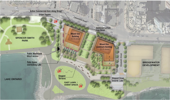 The rendering is a Preferred concept the city put out several years ago – it used John Street as the entry point to the development. The rendering also describes the east lawn as event space. Is that space part of the Hotel property or is it land reclaimed with land fill and under the control of Conservation Halton? We wrote to the planners working for the developer asking if they would send us a high resolution graphic that we could publish and explain to our readers.
We did not get a response – which seems to now be a pattern.
Recall that earlier we had been told that the pre-application was being recorded and would be available.
In a separate story – there is a link to that below – we explain how we had to badger both the developer and the city planning.
We took the poor quality graphic and had one of our people enlarge it – the quality isn’t all that good – it was the best we could do with what we had.
The people working for the developer clearly do not want the public to be aware of what their early stage thinking is.
There are two issues at work here. We have always lived by the maxim: an informed public can make an informed decision.
With that in mind we will explain what we know about the site.
The planners working for the developer are required to accept your comments and to make them available to the city planners.
The man who wants to hear from you is Evan Sugden – his contact information is
Evan Sugden
esugden@bousfields.ca
Bousfields Inc
1 Main Street East, Suite 200,
Hamilton ON, L8N 1E7
(905) 549-3005 ext. 259
In order to comment you need to know something about the development – with less than 125 people taking part in the virtual pre-application presentation, there isn’t going to be much depth or breadth to what they developer hears.
Spencer Smith Park and the waterfront part of the city is YOUR property – you have the right to have input – Mayor Meed Ward made sure that you had that right when she pushed for the use of pre-application presentation sessions and she made sure that the Mayor and the ward council member had the right to be part of the presentation. Odd that the Mayor didn’t say very much when she had the chance. She did say that the city had not received an application.
Now on to the graphic…
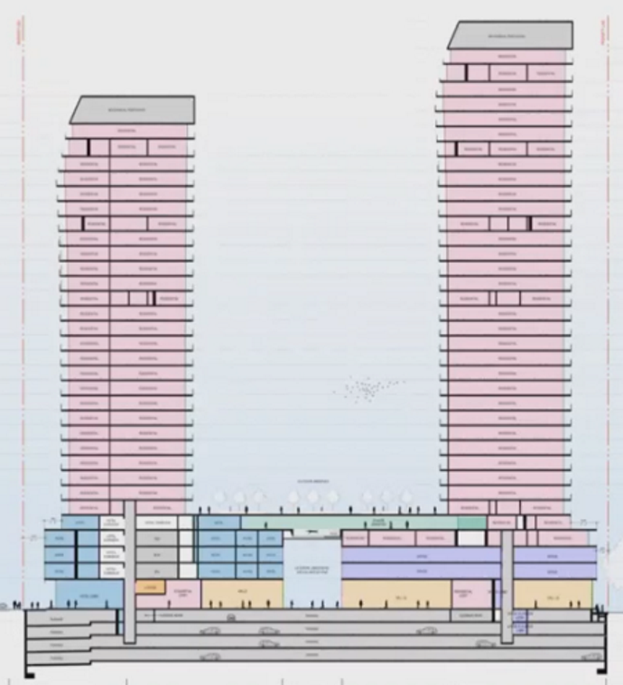 The pink color are the residential units; blue is the hotel which is limited to the podium, the amenity spaces are in green. That upper level serves as a kind of bridge that connects at the podium level. The office functions are shown in purple. There are currently two levels of office functions. Commercial uses are shown in orange. There is a substantial grade stepping from Lakeshore down to the Waterfront Trail. In terms of unit break down, we have 23 units or Studios, 212 units as one bedrooms, 165 plus one bedrooms plus den and 139 as two bedrooms and some units of three bedroom for a total of 557 units between the two towers. Related news stories:
The pre-application meeting September 8th
An alternate idea that has gained some traction.
Getting the video of the pre-application meeting was easier said than done – both city and the developers planner had to be badgered.
By Pepper Parr
October 6th, 2021
BURLINGTON, ON
Planner Alison Enns, Manager of Policy and Community, delivered a report on Floodplain and Spills Approach: Lower Hager and Lower Rambo Creeks. It was treated as a Receive and File document.
 Alison Enns, Manager of Policy and Community, It turned out to be a lot more than that – the information in the report has the potential to threaten some of the planned development along the path of Rambo Creek.
Enns purpose was to share how changes over time, new tools and approaches and the results of Phase 1 of the Flood Study, undertaken as part of the scoped re-examination of the Official Plan, have informed a change to how development in the Downtown is reviewed related to hazards south of the Hager/Rambo Diversion Channel.
Since the early 1980s the City has addressed development with respect to potential flood hazards in coordination with Conservation Halton. The Phase 1 Flood Study, finalized as part of the scoped re-examination of the Downtown, used new technology and information to identify hazards. That new information has informed a shift in responsibility from the City to regulation by Conservation Halton (CH) as of June 16, 2021.
Enns put up a slide showing the location of Hager, Rambo diversion channel.
 Blue line indicates the path of the Rambo Creek diversion channel. The diversion channel was constructed in 1976 to divert water from residential areas around the downtown to prevent flooding. The main diversion channel captures water flow from upper Hager and the upper Rambo systems. It is approximately 2.7 kilometers long and outlets to Indian Creek, which in turn empties into Hamilton harbour and Burlington Bay.
In the early 1980s, the Halton Region Conservation Authority, in a memo dated September 7,1982, stated that the Conservation Authority doesn’t exercise jurisdiction over the Hager and Rambo Creek or the diversion channel. From that point forward drainage areas south of the diversion channel were considered to be under municipal jurisdiction and constituting part of the municipal storm drainage system.
The city addressed development with respect to the potential for flood hazards in coordination with the Conservation Authority, The regulatory policy was updated in 1999 and again in 2006, and in both of these documents that approach was confirmed.
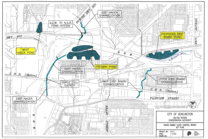 The storm water ponds that feed into the Rambo Creek diversion channel. The various ponds, and their connection to the diversion channel are shown. Some context to help make the point about how we got here at the outset of the mobility hubs study…
There was an identified need for a scope of storm sub watershed assessment. Through that work and then subsequently through the work related to the downtown the scope re-examination, a final scope of that work was determined. In 2019 and carrying into 2020 the city retained Wood Consulting, in partnership with the Conservation Authority, to do a set of studies, which were called the flood hazard in storm water management assessment – commonly referred to as Phase One flood study. The purpose of that study was to define existing flood hazards for the areas where new development was anticipated, and also to develop a set of preliminary storm water management strategies. It also included reviewing drainage infrastructure capacity.
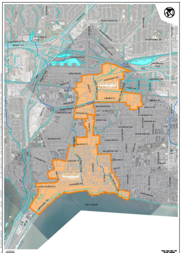 The map shows both the current but expected-to-be revised Urban Growth Centre and the boundary of the Burlington MTSA. It was while thinking through policy options that a concern about flooding became an issue. That concern led to two reports that highlighted a serious problem – the challenge now is how to deal with the flooding issue. The climate has changed – now what?
This is the extent of the phase one study area – note that it includes the downtown, and the Burlington GO.
The findings of the phase one study inform the development of policies and mapping that were endorsed by council in late 2020, and were incorporated in the approval of the new official plan by the Region. The Phase One study also identified that further technical work would be required. The recommendations of Phase One included identifying flooding hazards, providing recommendations for area infrastructure improvements, and included discussion of storm water management criteria but, really, the key elements of the Phase One work was to say that further technical work would be required to refine and confirm the flood vulnerable areas. That would be done through a phase two study which is currently underway using more detailed topographic survey data.
After the completion of the Phase One study, Conservation Halton, in accordance with the Conservation Authorities Act, determined they would exercise regulatory authority over lands in the vicinity of the lower Rambo Creek in downtown Burlington.
The city has incorporated this information in the Official Plan through the new official plan and Conservation Haltom has incorporated these new areas subject to flood risk in their mapping, which is available online.
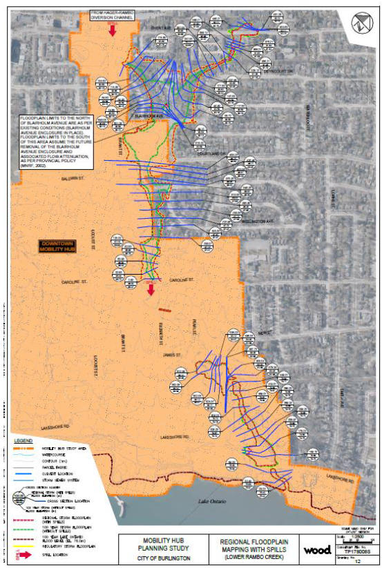 The scale of this map makes it very difficult to show the detail. We will try and get a map with better resolution and then present the map in sections. What is evident is that there are a lot of developments that are in what is thought to be a flood plain. Think of the damage done when the Tuck Creek broke its walls and flooded hundreds of homes. The city wants to take action now to put policies in place that will determine what can be built in possible flood prone areas. June 16 2021 is the date after which Conservation applies the regulatory regulations to these areas.
Council saw the draft terms of reference in June. Staff is moving forward, refining the modeling from the Phase One study. That will determine if any further policy changes are required or any mapping changes. While Phase Two is not complete the Phase One study is considered best information; city and Conservation Authority staff will use that information to support the review of development applications.
With the Enns presentation completed – It was then on to Questions from Council. Mayor Meed Ward asked: when you look at the development proposals we have for the downtown many are identified as being in flood hazard areas. This may be, she continued, too early to answer this question but what does that mean, what do we know about what that means right now – does it mean no development there – does it mean, different kinds of development? What, what do you think it means – if you can answer that right now? With all the applications we have there appear to be a lot that are in a flood hazard area.
Enns had indicated that applicants will be required to interact with Conservation as part of the normal development approval process.
Councillor Nisan and the Mayor sit on the CH board and are aware that typically permits are not issued for developments that are within a hazard, that’s one of the protection areas. And in cases where the hazard can be mitigated, a permit with conditions might be issued.
What the Mayor was trying to get at is the potential that given the risk to health and given what we now know about flood hazards that permits will not be issued in some of these areas at all.
Through the permitting process, we would anticipate that depending on the issues that are present from a regular flood regulatory standpoint, this will influence design, and certain design outcomes as it relates to those projects, which is tied into the land use permissions. So we would not be proceeding from a planning standpoint to recommend approval of designs and final outcomes that conflict in any way, with the proper maintenance of the flood risk.
Any idea of when the phase two study might be complete and when we’ll be getting that information?
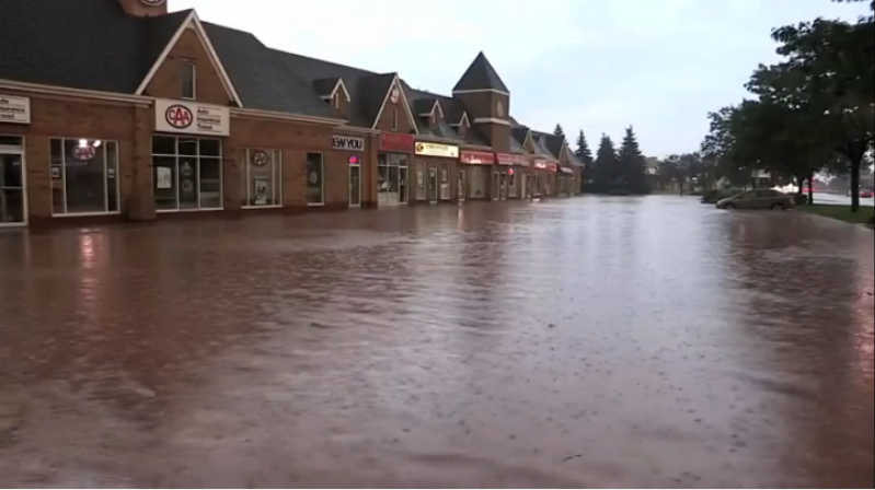 If there were basements in these buildings where records and archived documents were stored – they were a soggy pile of useless pieces of paper. The target for completing phase two to line up with the MTSA work is, Q1 March of 2022. That work is happening very quickly and will help us answer some of these questions.
At that point Councillor Nisan was asked to move the item and it carried unanimously.
And with that – the fox was in the hen house. All those developments before the Planning department now face another hurdle that could determine if the application can proceed or if it should be modified to reflect the flood potential.
The developers would appeal to the Ontario Land Tribunal (OLT) – it would be very hard for an OLT Commissioner to find for a developer when looking at public safety issues.
This one should be really interesting going forward.
 By Staff By Staff
October 3rd, 2021
BURLINGTON, ON
In language only a bureaucrat or a lawyer can write the plans for a four storey retirement home on Kerns Road are set out.
The development will replace a very small strip mall in a neighbourhood that is made up of windy, well-treed streets and large single family dwellings.
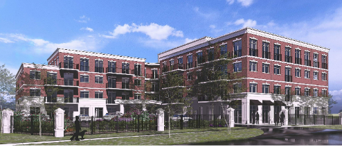 Architectural rendering of the proposed retirement home development The proposal will be described and defended by Glen Wellings, (the planning consultant hired by the developer) at a Statutory meeting on October 5th at 1;00 PM. .
The Statutory meeting will be a virtual event which in the past has dampened public participation for many, but not all developments.
A virtual meeting is a different kind of public event – there is no sense of community, the speaker is in a virtual space where they can see the members of Council taking part and the Council members can see the person delegating. There is no sense as to how many people are actually watching the web cast.
If the person delegating wants to use some visual material, getting it to actually appear is not a certainty – there are still technical issues that have not been overcome.
Some municipal councils have moved to a model that runs both a virtual event alongside a live event. People can choose which route they want to take.
The Halton District School Board meets with half the trustees in the room and the other half taking part virtually.
Burlington City Council has a report on a possible return to meeting that will be live but with limited public participation and all staff participation being virtual. The pandemic is still very much with us – and so is the phrase “with an abundance of caution” which is being overused to the advantage of people who are not strong believers in full public participation.
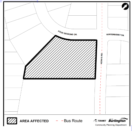 Bound by Kerns Road and Four Seasons Drive the property currently houses a small strip plaza. What is Proposed?
A private land owner has made an application to change the Zoning By-law designation for the property located at 1600 Kerns Road. The location of the subject property is shown on the Location Sketch.
The application proposes the rezoning of the property to facilitate a retirement home having a height of four storeys with one level of underground parking and comprised of 123 units.
The proposed development also contemplates commercial uses at grade.
 Four views of the proposed retirement home development. The building will be terraced on the south side
The subject lands are currently designated ‘Neighbourhood Commercial’ in the City of Burlington Official Plan (1997), as amended and ‘Local Centres’ in the New Official Plan (2018).
The applicable zoning of the subject lands is ‘Neighbourhood Commercial (CN2)’ Zone. A site-specific exception (‘CN2-XXX) Zone’) has been proposed with amendments which include, but may not be limited to, matters related to permitted use(s), setbacks, height, parking and landscape buffers.
The portion of the lands associated with the Natural Heritage System are proposed to be rezoned to ‘Open Space (O2) Zone’ and dedicated to public ownership.
By Pepper Parr
September 29th, 2021
BURLINGTON, ON
It was during a meeting on that wonderful deck that runs along the north side of Lakeshore Road – across the street from Spencer Smith Park where one can see the ships heading to, or leaving, Hamilton harbour and where, what a long departed friend said, one can enjoy an Adult Libation.
 One of the prime places to just enjoy the city is on the north side of Lakeshore looking out over the lake. Great ideas bubble to the surface while enjoying an Adult Beverage, I was meeting with a couple of friends and talking through possible options and new ideas to keep the Waterfront Hotel site in public hands rather than have a large tower go up.
At the time no one knew that the developer’s plan was for two 30 story plus towers on the site.
Many see the land south of Lakeshore Road as a “public” part of the public realm. Much of it is land that was recovered and made usable with landfill.
The owners of the hotel do have title to some of the land but surely not all the land right up to the edge of the lake.
My friends, who don’t want their names trotted out at this point – at an appropriate time they will be more public. These are men who comment intelligently on public matters.
They wondered aloud if there was not some kind of land swap that could be done.
And that was when a light bulb lit up.
 It doesn’t function all that well as a place to work and the city is going to need a lot more space. City hall as a building is not that functional. It is past its best-before date but, because it is what we have, money is going to be spent on making the best of a bad situation.
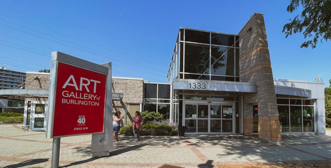 It is an awkward building – there was no real design – additions kept being added. The entrance was once on the west side. The Art Gallery has never been a truly functional building. It is a collection of additions to a structure that were added on when there was a donor.
So – here is a swap that could be done:
 The owner wants to build and has some impressive designs – that will, if ever built, change the heart and soul of the city. There is a chance to give the developer what they want and to save what is left of Burlington. Exchange the Waterfront Hotel site for the city hall site and the Art Gallery site.
Then design a purpose built building that would house City Hall and the Art Gallery on the Waterfront Hotel site.
Include a band shell and ensure the roof of the structure is environmentally friendly. And ensure that the building is not more than four storeys.
Two for the Art Gallery and two floors for the city.
Hold a charette and commission some design ideas from architects from around the world.
Imagine for a moment: City Hall and the Art Gallery nestled at the base of the slope of the land immediately south of Lakeshore Road leaving a clear view of the Lake. Try the idea on for size the next time you are walking along the promenade and talk it up with your friends.
Parking – that is something that would have to be figured out. The Lotus Street Parking lot is used by city hall staff now – that could continue and there could be some parking beneath the four storey building.
Can’t be done you say? With the right leadership – it certainly can be done.
 Rob MacIsaac, a former Burlington Mayor, took bold steps and changed the city in a way that no one has since his time. Rob MacIsaac, a former Burlington Mayor, did it when he turned the former police station on Locust into the Performing Arts Centre, then had the building that houses a restaurant along with the tourist office on the ground floor and office for the Chamber of Commerce, the BDBA and the Economic Development Corporation on the second floor with five levels of parking above it all.
Then he got really ambitious and got a pier built as well.
So – never say it can’t be done – think about how it can be done and where the leadership is going to come from.
More on this going forward.
Salt with Pepper is the musings, reflections and opinions of the publisher of the Burlington Gazette, an online newspaper that was formed in 2010 and is a member of the National Newsmedia Council.
By Pepper Parr
September 24th, 2021
BURLINGTON, ON
Mayor Marianne Meed Ward once said that fireworks were something she heard about from residents almost as much as parking.
Parking – where do the people driving put their cars when they want to shop, or visit or dine?
Back up a bit and ask – where are all the cars coming from?
Back up a bit more – when a development application is filed with the Planning Department one of the reports that must be included is a traffic study.
Look at any number of those studies and they will all say that the number of cars that might be added to the flow of traffic in the city is “acceptable”, or words along those lines.
The people who write these reports are seen to be professionals who know their craft very well and their evidence is accepted as true.
The traffic reports get an OK from the planners.
And – the OK for that single traffic study might be very valid.
But there is a bigger picture that has to be looked at – and at this point no one is looking or asking the question.
 All the traffic from the underground garage will exist on to Elizabeth, shown on the left. To the left of the development is the site for whatever the Waterfront hotels site ends up looking like for the site The hundreds of cars coming out of the Bridgewater Development will exit the development onto Elizabeth street and then can continue north or go right or left on Lakeshore Road.
The hundreds of cars that are expected to come out of the proposed redevelopment of the Waterfront Hotel site also empty onto Elizabeth Street and then can continue north or go right or left on Lakeshore Road.
While this is, at this point in time, a Ward 2 concern it will become an issue elsewhere when the large developments along Fairview and in the east end of the city come online.
We challenge Councillor Kearns to look for a way to require traffic studies to focus on the impact the single development will have (they are already required to do that) AND to provide a report that sets out the impact their development will have on new developments already approved within a 120 metre radius.
The planners can work out the specifics; the objective is to have information that sheds light on that bigger picture.
It is the bigger picture – everything happening within a specific radius that isn’t being looked at.
The city planners don’t ask – they aren’t required to.
We don’t quite why Heather MacDonald, Chief Planner doesn’t go before council and point out that they are not asked to report on the bigger picture – and ask Council to give them a Staff Direction to do just that.
At some point someone has to get ahead of the problem and ask the bigger question.
If we don’t the phrase in the Official Plan that has Burlington as a “City that Moves” will have to add – moves very very VERY slowly.
To Lisa Kearns and Heather MacDonald – the ball is in your court.
Looking forward to listening to what you put before Council on this one.
Salt with Pepper is the musings, reflections and opinions of the publisher of the Burlington Gazette, an online newspaper that was formed in 2010 and is a member of the National Newsmedia Council.
By Pepper Parr
September 21st, 2021
BURLINGTON, ON
On the evening of September 8th, there was a virtual pre-application presentation given by Bousfields, planners for Burlington 2020 Lakeshore Inc. , which is the company expected to make the application.
It was the first look at what the property owners had in mind for the re-development of the Waterfront Hotel site.
Two things about the images shown below – we were able to show a bit of what the developers have in mind last week.
I think the design is superb.
But I don’t think that design is what the people of Burlington want. It is some distance from the slightly quaint look of the downtown core, which isn’t all that big. It is my belief that there isn’t all that much vibrancy to it. But that’s my personal view.
The decision that gets made about this development is to be made by the people of Burlington.
Unfortunately the people of Burlington didn’t get to see the presentation.
There were just over 100 people participating in the virtual presentation – of which at least a dozen were city staff.
During the Q&A part of the presentation the Gazette asked how we could get a link to the presentation which was recorded.
No one had an answer so on September 11th, I reached out to the Director of Communications Kwab Ako-adjei with the following:
Greetings
I think you will have taken in all of the pre-application virtual meeting on Wednesday.
Quite a show.
As you know it was recorded and the developer didn’t raise any objection on it being made public – what wasn’t clear was –
Thomas Walker (I erred and used the wrong last name – it is Douglas) was asked and didn’t seem to know where it would be located nor did he leave me with the sense that it would actually be put on the city web site.
Would you follow this up for us please.
I address this to you because we intend to follow how the request is handled and want to be on record as having reached out to the head of the Communications department.
Stay well
I later got a reply from Carla Marshal, who is one of the Communications Advisers with the city.
Good morning, Pepper.
Please take a look at this information, which should help to clarify the City’s role in the development application process: Understanding the Development Application Process – City of Burlington
The meeting was led by the developer so the developer owns the recording of the event. The City does not own the recording; the developer does. It is at the sole discretion of the developer, in this case, Burlington 2020 Lakeshore Inc. c/o Bousfields Inc., if and where the recording is posted; it is up to the proponent to decide whether they will post the recording online on their own website: https://bousfields.ca/
Shortly after there was a response from Suzanne Vukosavljevic, who was filling in for Marshall.. She said:
The City posts its own meeting recordings on the City site but in this specific case you are asking about, it was not a City meeting so therefore, the City is not posting the recording.
Your questions have been answered by staff below.
Thanks for your interest.
The city provided the following:
As the communications advisor for Planning, I have worked with staff to provide you with the following information:
From Thomas Douglas, Senior Planner, Community Planning:
Pre-Application Community Meetings are hosted by the proponent of a development, not the City. If/when the proponent proceeds to submit a development application to the City for their proposal, as part of their application they must provide minutes from the Pre-Application Community Meeting, a written summary of public input received at the meeting, and an explanation of how public input has been addressed and reflected in the submitted application.
In cases where a Pre-Application Community Meeting occurs virtually, this may be done using the City’s or the applicant’s teleconferencing program. When the City’s technology is used, staff will record the meeting and provide the recording to the proponent to aid them in documenting meeting minutes and public input received. The City does not post the recording on the City’s website, and it is up to the proponent to decide whether they will post the recording online on their own website.
I will inform the proponent of the 2020 Lakeshore Road development proposal that the Gazette has expressed interest in obtaining a copy of the recording.
I hope this helps!
I didn’t feel my request had been met and responded:
Actually it doesn’t help very much. I then set out more specifically what I was looking for: Carla’s responses are short – set in red.
Does the city have a copy of the event that was recorded? No
Pre-Application Community Meetings are hosted by the proponent of a development, not the City.
If not – does the city intend to obtain a copy?
No
and where will the copy be located on the city web site
The meeting recording will not be located on the City website; it is up to the proponent to decide whether they will post the recording online on their own website –
Further: whose technology was used – re: using the City’s or the applicant’s teleconferencing program. When the City’s technology is used, staff will record the meeting and provide the recording to the proponent to aid them in documenting meeting minutes and public input received.
The applicant has the recording.
Further – who would make the decision to not post the recording, should it become available on the city web site.
it is up to the proponent to decide whether they will post the recording online on their own website
I reached out to the planner Bousfields and asked where we could get a link to the presentation. And waited.
This morning there was a response from the Bousefields planner with a link to the presentation.
And later in the day there was a link from Thomas Douglas with the same link.
That’s a lot of back and forth – but we did get what we were asking for. Why the difficulty is beyond me.
There are two images below. They are of what the building will look like from Lakeshore Road and what it will look like from the Lake.
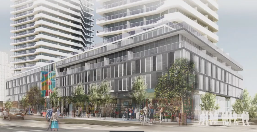 A rendering of what the development might look like from Lakeshore Road. Commercial space will exist at grade.
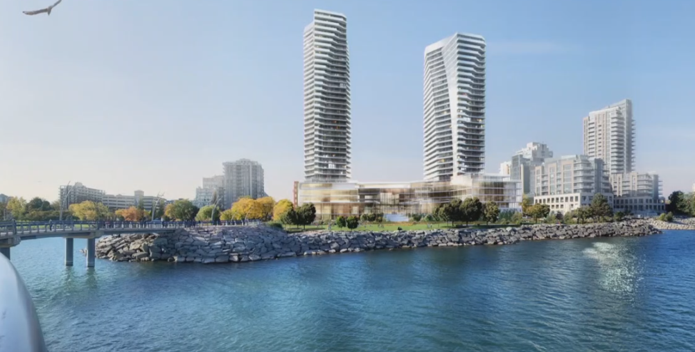 A rendering of what the site will look like from the Lake. Each tower will sit on a four storey podium and then rise to 30 storeys and 26storeys. In part 2 – there is more in the way of visuals and comment on how the virtual event went and what was learned.
The developer can now submit an application.
When and if they do – they are expected to show how they responded to some of the issues and concerns that were raised.
Bousfields added: Note that the plans are not final and are subject to modifications as we move forward. No formal applications have been submitted at this time, and the public meeting was simply to gauge public interest and explain the proposed intent for the site prior to submission of formal planning applications.
By Pepper Parr
September 11th, 2021
BURLINGTON, ON
Saturday afternoon in the city. Weather was great but the streets in the core were quiet – patios weren’t’ all that populated and that place to be seen on the north side of Lakeshore Road west of Brant was very quiet – you could actually get a seat.
Slide down into Spencer Smith Park and head west and there were line-ups more than a block long – people waiting to get into the Food Truck Festival.
 The lineups to get into the Food Truck Festival were long but they moved very quickly. The line moved quickly – security was keeping a count on the number of people who would be let into the fenced in area. There was an entrance and an exit gate. Inside, all kinds of people – but it wasn’t packed – the objective was to make that six foot distance thing possible.
 Great crowds – but no overcrowding. Security ensured that the count was kept at a safe level. While downtown, one wants to check on the construction sites and see how the high rise developments are doing.
Spent a couple of minutes in front of the Waterfront Hotel site to try and get a sense as to just how close to the sidewalk those 30 and 24 story buildings would be.
The first four levels would be at about where the red arrow is on the photograph. It isn’t clear how far back on the four level podium the towers would be. Lakeshore will never be the same – you won’t be able to see or feel the lake.
If there ever was an iconic location – Spencer Smith Park and the lake are it for Burlington. Done the right way the site could put the city on the map as a destination. Few feel the ideas being floated are the right thing for the city.
 The red line is where the north wall of the four level podium would be located. Atop the podium would be 26 storeys of housing.  Each tower would sit atop a four level podium. There would be an open space between the two towers that would be at about where John Street is – that opening would give a glimpse of the lake – the property has a steep grade – much like the one at the Bridgewater development a block to the east. 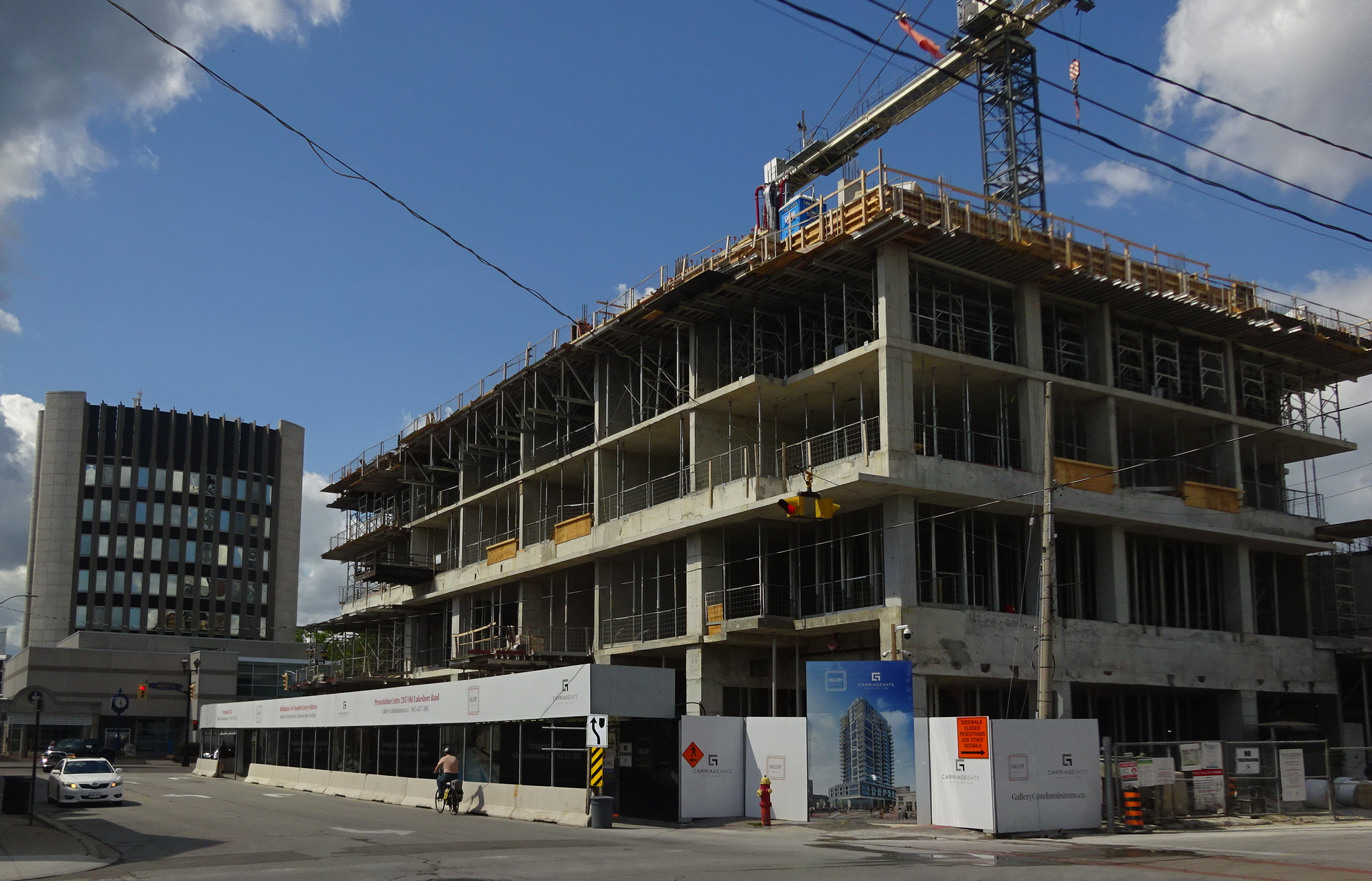 Named The Gallery – the Carriage Gate development is well underway. Four floors in place, underground garage completed – 22 more to go. The 28 storey tower Carnacelli development is growing level by level. Four levels have been poured – 22 to go. Occupancy is said to be sometime in 2022 – at that time citizens will get to know what a high rise building is and what it feels like to have one opposite city hall.
By Pepper Parr
September 9th, 2021
BURLINGTON, ON
Are we ready for this?
They will stand on Lakeshore Road between Brant and Elizabeth Streets. The required Pre-Application meeting took place virtually last night.
There was some expensive talent talking on behalf of the developer who wants to put up two towers: a 30 storey and a 24 story.
The plan is to have 23 studio apartments; 212 single bedroom apartments; 165 1 bedroom + den; 139 2 bedroom and some 3 bedroom. No mention of price.
The panel was asked if there would be any affordable units – really?
There will be a significant bike tails system – but they won’t extend out onto the Pier. – even thought they appear to do so in the report.
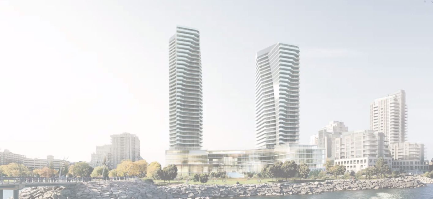 View from the lake. Downtown Burlington will never be the same if this gets approved as it has been presented. During the presentation, given by people representing the developer, David Faletta attempted to convince viewers that the old Urban Growth Centre boundary would apply arguing that the Regional Official Plan affirmed the new boundary but that the Minister had yet to sign off on the Regional decision.
There is a lot more to this story. Stand by.
|
|