By Pepper Parr By Pepper Parr
October 28th, 2020
BURLINGTON, ON
We are back to the growth issue, which many in Burlington see as a height issue.
People want things to remain the same – keep the nice stuff, the streetscapes that have been in place for decades and that we are comfortable with and the shops we have known and patronized for years.
The current city council worked hard for more than a year to put in place an Official Plan that would permit the growth the province was forcing on the city and at the same time protect neighbour hoods that give the city the image it wants – a community with loads of single family residences with decent yards and well treed streets that are safe to walk along in the early evening.
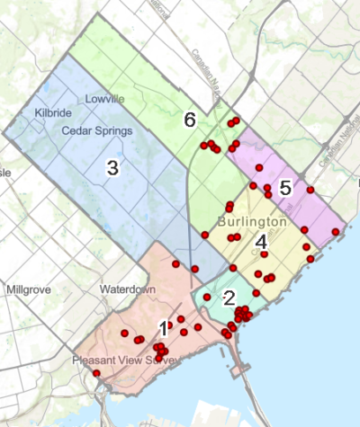 Each red dot identifies a development proposal that the Planning department is working on. There are close to a dozen that have yet to actually get to the Planning department. What they, and the Planning department are up against is a daunting 30+ development plans that are somewhere between a twinkle in a developers eye and an application that is deemed complete by the Planning department.
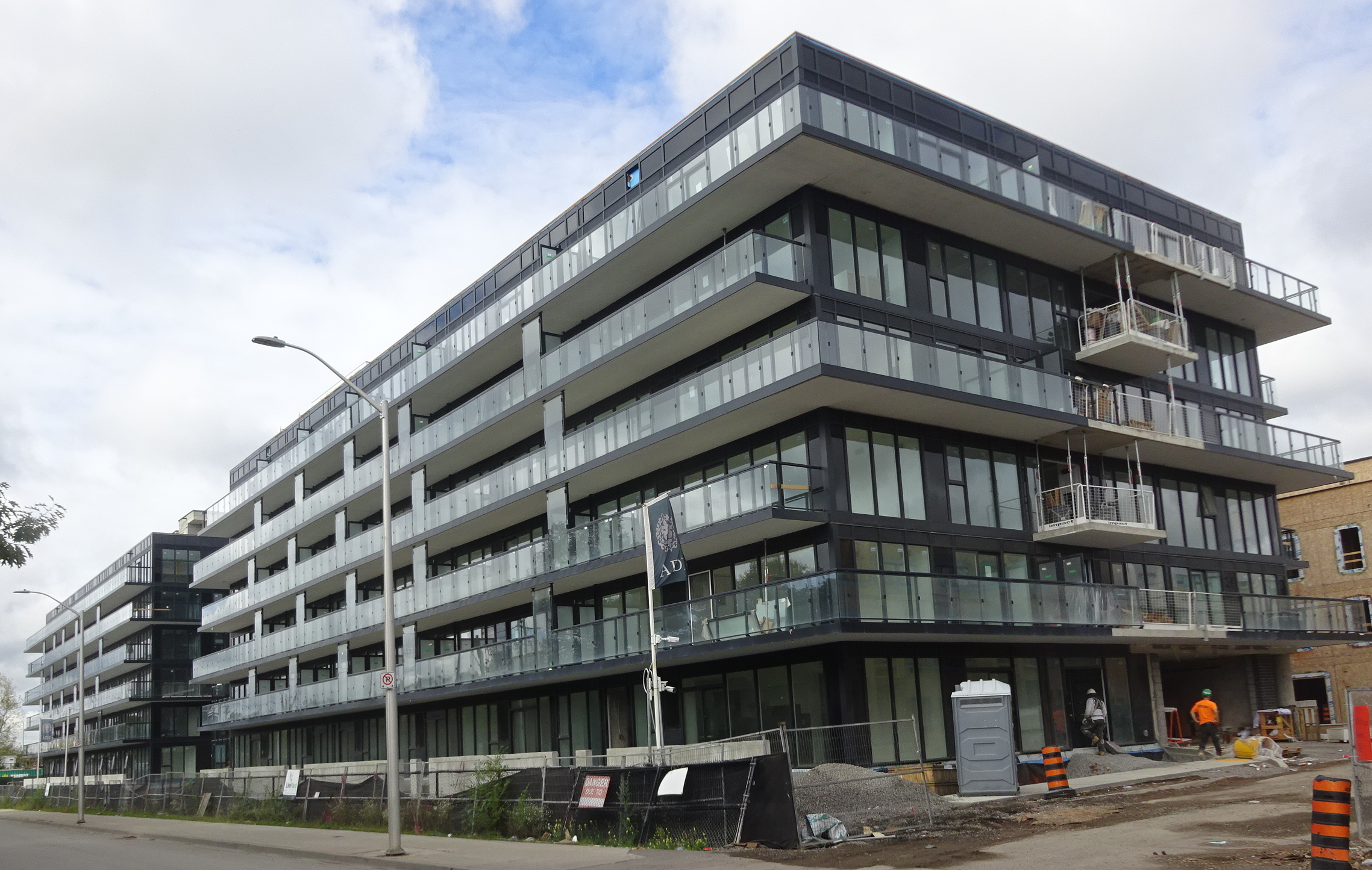
 The digging down deep for the four floors of underground parking is underway. When the Carriage Gate people got the 24 storey’s they wanted (the Council at the time was prepared to give them17) that seemed to open things up for the developers; 20 plus was the going rate in terms of height and that set a value on the small two storey commercial property on Brant. The owners of those properties began to see dollar signs in their eyes and looked forward to cashing out.
 Proposal for the property north of Caroline – next to Joe Dogs. The Renimmob virtual preconsultation meeting earlier in the week heard the same wish – keep the retail we know and let us live in a community that accepts growth – they just don’t want it towering over them. They were asking for
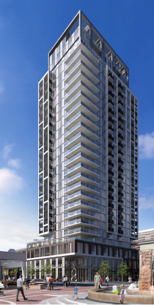
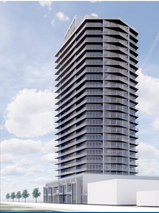
A 26- storey mixed use building with approximately 248 residential units, including a mix of one, two and three bedroom units (subject to change) and ground floor commercial.
Earlier in the month the Molinaro Group put forward their development proposal, a three phase development that would take three of the four corners at Brant and Ghent and see heights of 25 storeys.
Phase 1 – 774,778,782 Brant Street;
Two 25-storey residential mixed use buildings with 426 units and 420 square metres of retail space at grade.
Phase 2 – 769,779,783 Brant Street and 2023, 2027, 2031-2033 Ghent Avenue;
One 25-storey residential mixed use building with 316 units, 405 square metres of retail space at grade and 7 separate townhouse units.
Phase 3 – 747,761 Brant Street
A 6-storey residential mixed use building with 108 units and 997 square metres of retail space at grade.
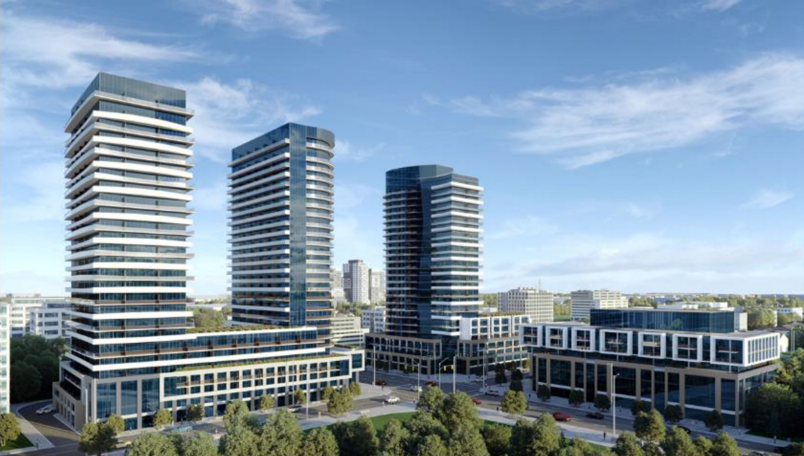 When completed the development will take up three of the four corners at Brant and Ghent. The Molinaro architect talked in terms of the development becoming the “gate to the downtown core”. Would that set the standard at 25 storeys?
The development did have a couple of pluses – the design for the high rise towers on either side of Brant is very smart – if it is to become the northern “gateway” to the city it will be very attractive.
The Molinaro people also gave up some height with the townhouses that are proposed for the east side of Brant. They are asking for six storeys when they are allowed 11 in the Official Plan the city is waiting to get approved at the Region.
Molinaro want 25; the Renimmob people want 26.
Is 25 going to become the standard should these applications get to LPAT if the city doesn’t decide it can live with something above the proposed 17 floors?
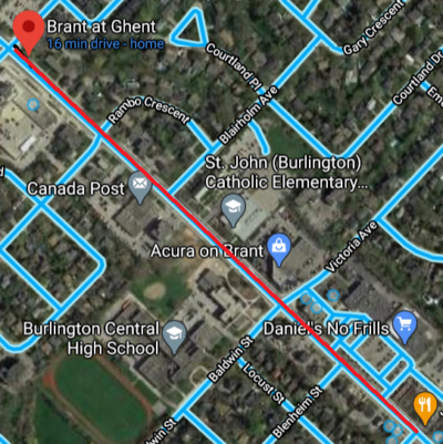 The distance between the proposed Molinaro development and the Renimmob development is four city blocks. The city wants that high growth to be clustered around the Burlington GO station where there is no limit for height at this point.
The development community does not appear to have given up on the opportunities they believe exist in the city.

By Pepper Parr
October 27th, 2020
BURLINGTON, ON
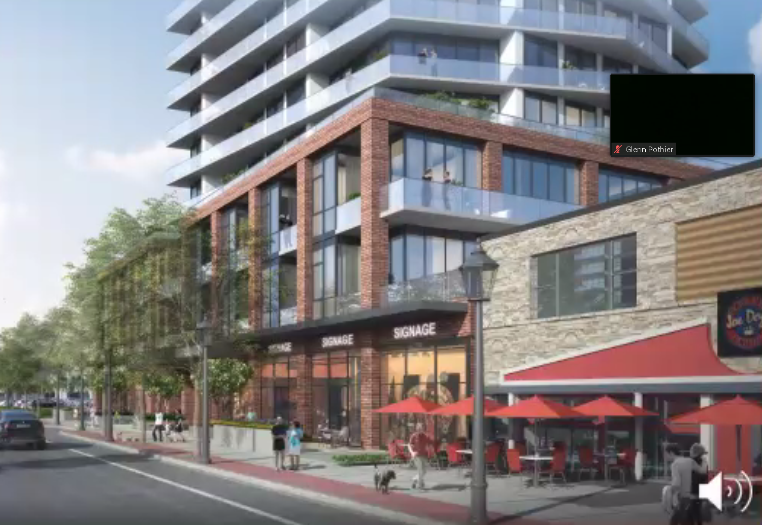
 This is the first view the city had of the development The opposition to the building started the day the public saw the rendering for the first time.
Renimmob Properties Limited, a developer new to Burlington bought the property from the south end of the No frills Plaza where the Bank of Nova Scotia is located south the lot that Joe Dogs is located on. The Joe Dogs site was not part of the land assembly.
The proposal is to put a 26- storey mixed use building with approximately 248 residential units, including a mix of one, two and three bedroom units (subject to change) and ground floor commercial.
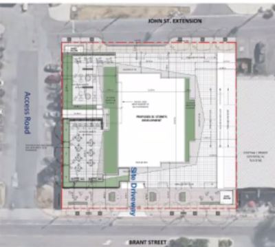 The tower would sit on a three story podium. Vehicle access would be on a road that will have to be created – it would run between John and Brant on what is now the northern edge of the Bank of Nova Scotia. The tower would sit on a three story podium. Vehicle access would be on a road that will have to be created – it would run between John and Brant on what is now the northern edge of the Bank of Nova Scotia.
Traffic and transportation were the issues that came up again and again. Both of which were going to be the result of the height which no one wanted. Under the in-force Official Plan the property is zoned for four to eight storeys. Under the Official Plan that has been adopted by Council but not yet approved by the Region, the height could be 17 storeys.
Brant Street is just two lanes at this point – there is no room to widen the road. The developer said there would be an eight metre sidewalk in front of the development.
 Looking north from the Joe Dogs location – which is not part of the development. 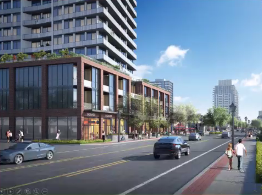 Looking south on Brant Street with the development on the left side. The rendering shows four lanes of traffic plus a bicycle lane. The street currently has a limit of two lanes of traffic.
 By Pepper Parr By Pepper Parr
October 27th, 2020
BURLINGTON, ON
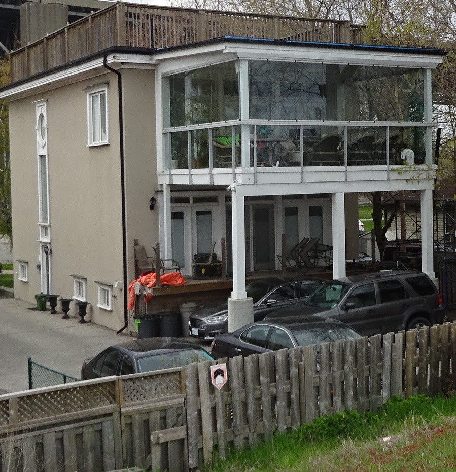
 First we lost Emmas and now it looks as if Joe Dogs might bite the dust –literally. First we lost Emmas and now it looks as if Joe Dogs might bite the dust –literally.
Last night the public got to see the drawings for the proposed 26 storey development on Brant immediately south of the No Frills Plaza
The southern edge of the development snuggles right up against the build Joe Dogs is in.
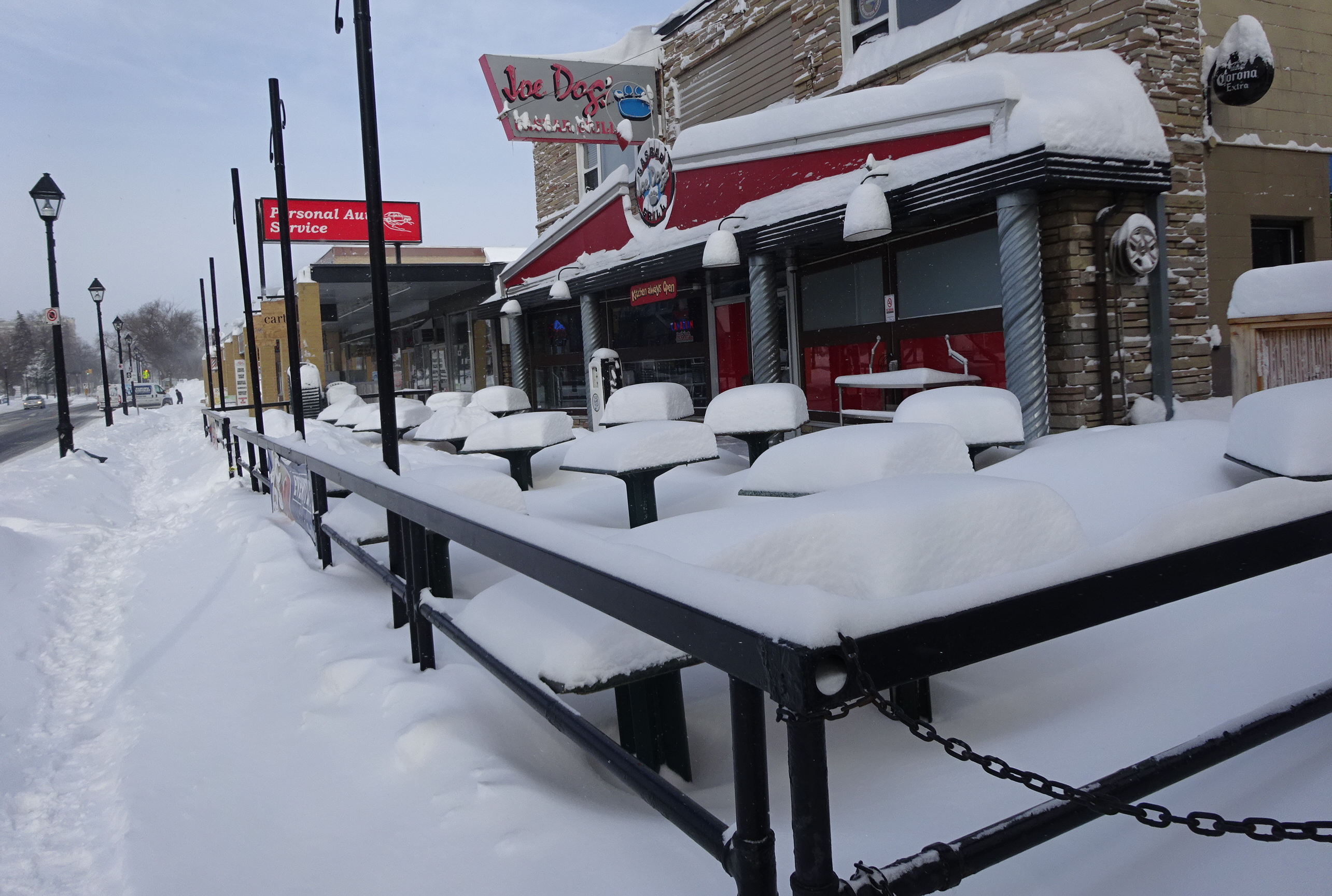 Joe Dogs on a winter day It would hardly be possible for the Joe Dogs operation to continue during the construction phase which is at least four years under the best of conditions.
 One of the owners of Joe Dogs “What’s going to happen to me” asked one of the owners of Joe Dogs.” What is your plan for me? We have been in business for 23 years in this location and we don’t plan to move.
David Faletta said there had to be a construction management plan put in place which would set out what had to be done about the interests of neighbouring commercial operations.
COVID-19 took out Emma’s; construction dust just might make it impossible for Joe Dogs to operate in the same place.
Maybe Joe Dogs could move into the now vacant Emma’s building?
 By Pepper Parr By Pepper Parr
October 27th, 2020
BURLINGTON, ON
Is this the hill she will choose to die on?
Monday evening another of the Virtual Preconsultation meetings was held at which Renimmob Properties Limited listened to what the community thought of the plans for the property they bought on the west side of Brant street north of Caroline.
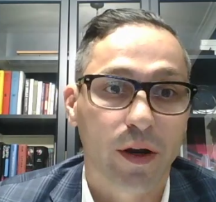 David Faletta – Renimmob Properties Limited At one point one of the callers asked what the relationship was between Renimmob Properties Limited and the Carriage Gate Group. David Faletta, one of the Renimmob operation said said they bought the property and and then brought the Carriage Gate in as advisors on managing the preconsultation process and getting an application through the city’s Planning department.
Strategically that was a brilliant move for the Renimmob people.
 Nick Carnecelli, Carriage Gate Development If anyone has managed to get things through the Planning department it would be Carriage Gate.
They were the first developer to get shovels into the ground on Brant Street where they are in the process of digging the garage levels for the 24 story The Gallery.
The have completed The Berkeley on John Street but have yet to start on the above ground garage or the planned six story medical centre that has been beefed up to 17 storeys.
The also have an application in the works for the tallest, (so far) planned structured on the north side of Lakeshore Road slightly to the east of Bridgewater Development and to the west of the Nautique.
The ask is a reported 29 storeys.
 Mayor Meed Ward listening to the speakers taking part in the Virtual Pre-consultation meeting. The Mayor has been going head to head against what the Carriage Gate Group wants to do.
For the Renimmob people to bring Carriage Gate in as consultants suggest this one is going to be a battle royal.
Fur and feathers will fly.
By Pepper Parr
October 24th, 2020
BURLINGTON, ON
It has been some time since we have heard anything about progress on the development of the Beachway Park.
We do know that the Region has been using their “willing buyer to willing seller” approach to buying up as many of the houses that are left in that once robust community.
 Bought by the Region and then torn down  Sold to the Region by the owner who rented the house for a few years. Then it was torn down The Region recently released a map showing who owned what – not much left in private hands.
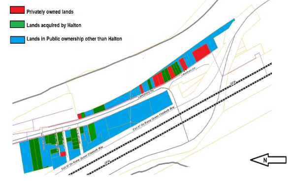 There was a time when there was a small community made up of people with modest incomes who lived in this part of Burlington where one of the best beaches in the province exists. Once the Region acquires a property they have it bulldozed to the ground, sprinkle some grass seed on the land and it becomes just another open space.
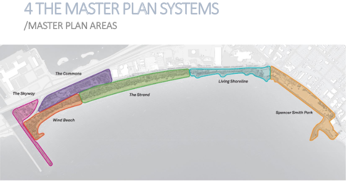
There are plans to turn the area into a park – not much news from the planners working on the project.
The public did get to see some renderings setting out what would be done. All there is at the moment are the six area park areas that have names attached to them.
 A study is in the works – not a lot of detail on just what the objective of the study is. A study is in the works – not a lot of detail on just what the objective of the study is.
We will see what we can pry out of the communication advisers the Region pays to keep us all well informed.
 By Staff By Staff
October 22, 2020
BURLINGTON, ON
With the application from Nelson Aggregates complete and accepted, the process of going through the numerous documents presented to support the request for additional licenses can begin.
The process is going to be daunting.
An extension of the Burlington Nelson Quarry would require Provincial, Regional and City approval. There is a sequencing of decisions required and parallel review processes happening at the provincial, regional and city level.
It will be years before there is a decision.
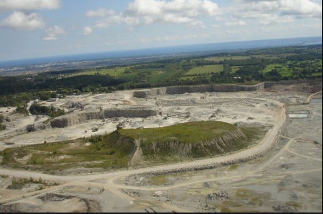 This site is close to being mined out – Nelson Aggregates has applied for additional licenses to expand The City of Burlington received an application to amend the Burlington Official Plan designation of the subject lands to expand the existing Nelson quarry operation on May 14th.
Ward 3 Councillor Rory Nisan said “Council is committed to a transparent process and I look forward to the project coming before the council table. I urge Burlington residents to get involved and to ensure their opinions about this application are heard.”
An extension of the Burlington Nelson Quarry would require:
Public consultation and engagement, including a statutory public meeting
Amendments to the Niagara Escarpment Plan and issuance of a Development Permit
Amendments to the Region of Halton Official Plan
Amendments to the City of Burlington Official Plan
An Aggregate License from the Province of Ontario, Ministry of Natural Resources and Forestry for the proposed expansion area
An application to the Niagara Escarpment Commission, Region of Halton and Ministry of Natural Resources and Forestry were received at the same time the City received an application.
A conceptual flowchart showing the parallel review process for the application is set out below. This process includes statutory timelines, application benchmarks, decision points and highlights opportunities for public consultation and engagement.
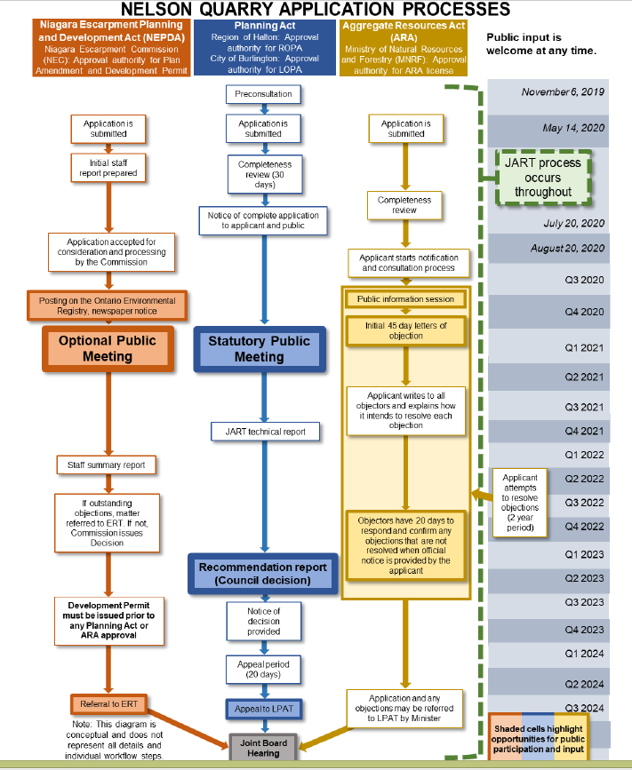
An inter-agency Joint Agency Review Team (JART) framework will be used to review the application for the proposed quarry expansion to ensure coordinated review by all agencies. The JART consists of technical staff from the Niagara Escarpment Commission, Region of Halton, Conservation Halton and the City of Burlington. The function of JART is to review the completeness of the application and analyze the proposal on its technical merits. JART itself does not make a recommendation on whether or not the application should be approved.
There will be regular reporting to Burlington City Council with progress updates and clarity on timing as the review process unfolds.
Prior to any decisions being made, public consultation will occur, including a statutory public meeting. The timing of the statutory public meeting has not yet been determined and will be scheduled once the technical review of the proposal has progressed further. Residents are encouraged to subscribe to the City’s Nelson Quarry Extension webpage Burlington.ca/nelsonquarry for up to date information on the application.
 Mayor Marianne Meed Ward along with Regional Planner Curt Benson (top right) and Ward 3 Councillor Rory Nisan taking part on the Cogeco cable channel. The quarry is in ward 3 Communications will go out to residents informing them about the opportunities to engage and provide their feedback on any requests for comments
Both the NEC and the MNRF will be releasing requests for comment on the Environmental Registry of Ontario. This is anticipated to occur within 2020, and the ability for the public, the City and other agencies to comment will be open for a limited time.
Mayor Meed Ward has said: “I know residents across our city and region are watching this very carefully because it affects us all. Our primary consideration will be how this will affect the health and safety of our community and the environment of this very sensitive area. I want to credit our Ward 3 Councillor Rory Nisan in ensuring residents know what is happening and are informed about the process so that they can be involved. There is a long road ahead.”
Related news story:
Residents don’t want an expansion – raising funds to oppose.
By Gord Pinard
October 22, 2020
BURLINGTON, ON
There are two things we would like to share with you today.
The first is this: we raised $8140 with our Pumpkin Fundraiser! We are absolutely floored by this number. Never in our most optimistic moments did we imagine that we could raise that much money from the sale of pumpkins. Thank you so very much to all of you who donated in varying amounts to this fundraiser. We are feeling encouraged in the truest sense of the word: your generosity has given us courage to continue this fight to protect our beautiful escarpment from the permanent environmental destruction that will arise if Nelson Aggregate’s application for two more open-pit mines is approved.
The existing quarry has a number of years left. Community resident want this to be the end of open pit mines on the Escarpment. Which brings us to the second thing: CORE Burlington consists of thirteen of your neighbours who have been working our hearts out for a year now, trying in every way we know how to stop this application from succeeding. We’re researching, reading dry reports on subjects that are new to us; we’re communicating to the public via our website, social media and email, in order to educate and update; we’re calling for critical emails-to-officials as required throughout the application process—which is complicated and involves approval from five different agencies!
 The shaded areas to the left and at the bottom are where Nelson Aggregates wants to expand But mostly, lately, we’ve been fundraising. Unquestionably the best shot we have at beating Nelson is to counter the case put forth in the review process by their lawyers and experts, with the case put forward by ours. We’ve raised just over $50,000 thus far, which we think is incredible. But we need to raise another $50K over the next few months and additional funding in 2021/22 in order to continue funding the expert help that has already begun.
Our fundraising team needs more worker-bees. We need help with planning and doing and donating and delivering. We also need some place to store the ‘in-kind’ donations we’ve been accumulating. Our next project is likely to be a pre-order gift basket sale for Christmas. We’d like to do an online silent auction as well, since we’ve had several wonderful silent auction items donated in the past while.
Is there anything you can do to help? Are you willing and able to join the CORE Burlington fundraising team? We’ve been doing our work via phone-calls, zoom meetings, emails and outdoor, distanced meetings. It’s been challenging to do this work during a pandemic, but we’re pretty pleased with our fundraising results so far. And we’re (honestly) having fun. Doing this sort of work is not such a bad way to find light and inspiration in these darkening COVID days.
Related news story:
The CORE argument
Gord Pinard is the spokesperson for Conserving our Rural Ecosystems
 By Pepper Parr By Pepper Parr
October 21st, 2020
BURLINGTON, ON
It was one heck of a meeting, delivered in a workshop format
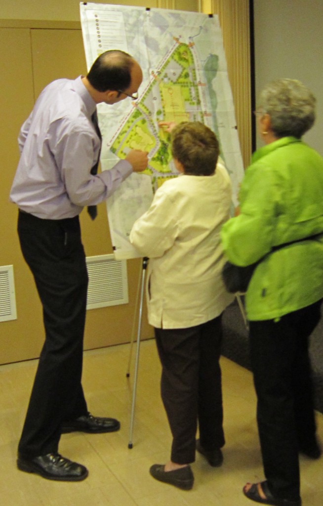
Angelo Bentivegna got to serve as chair; Jamie Tellier, currently the Interim Director of Community Planning, set out all the work the Planning Department has ahead of it. Councillor Stolte learned why zoning bylaw reports are numbered the way they are and city manager assured council that the 22 people that have to be added to the planning department staff will not all be taken on in one year – building the staff compliment will take about five years.
 Ward 6 Councillor Angelo Bentivegna is in the Chair Tellier has a delivery style that is a delight to hear – he laughs at the few mistakes he makes and chuckles frequently when he is explaining something. He is the kind of person who really puts the J in Joy. He used a number of slides to get his message across.
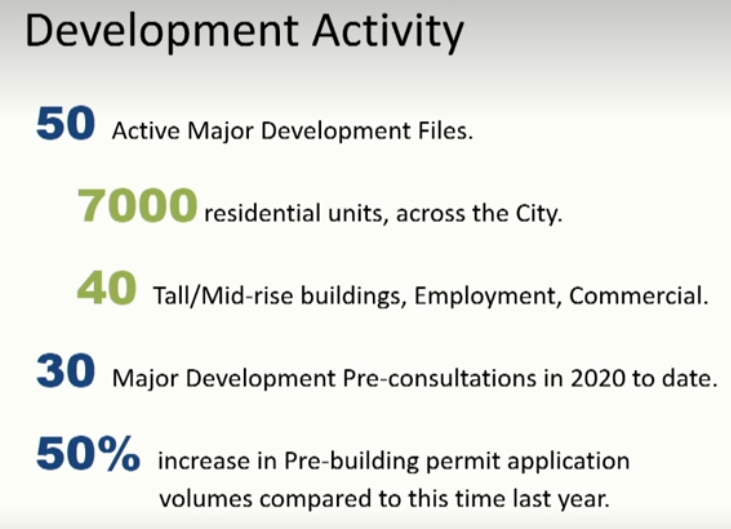 The numbers startled several of the Councillors – there was more to come. Tellier started out by telling Councillor that with the Scoped Review of the Downtown portion of the Official Plan completed and the Interim Control Bylaw in place until all the appeals at that level are completed, the planners now get on with the real job of growing the planning department so that it can cope with the work that is ahead of it.
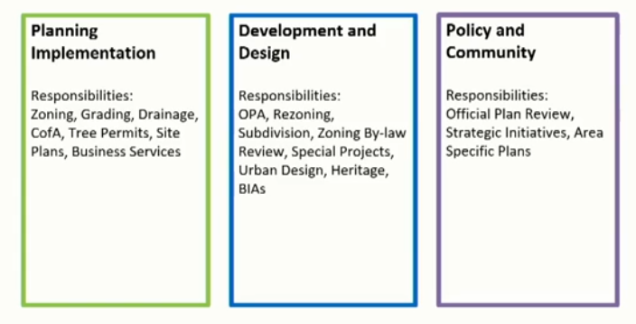
Tellier set out the organizational structure that is in place with three different working groups set out in the graphic below.
Council has always believed that development should pay for the work the planning department has to do. A consultant has been hired to do a Planning Application Fee Review; that report is due sometime in November.
Once full cost recovery is in place the planners will be able to bring in the staff they will need.
Tellier didn’t even try to hide his excitement over just how big a deal the passing of the Official Plan earlier in October was. “It was the end of a very long journey,” he said.
The next phase of that journey will take place at the Region on Wednesday (today) where the matter of the Urban Growth Boundary will be reviewed as well as the boundaries for what used to be called transportation hubs. They are now described as Major Transit Service Areas. (MTSA)
 Urban Growth and transportation – residential housing locations will be debated at the Region on Wednesday. The John Street bus terminal that was once called an MTSA has been deemed to be just a bus terminal – which is not defined in the the Planning Act and therefore not a concern.
At the Regional Council meeting Mayor Meed Ward expects to be vindicated for her long held position that the John Street bus terminal designation be removed.
There were those in Burlington who said this would never happen. They were wrong.
Burlington will have three MTSAs: Burlington GO station; Aldershot Go Station and the Appleby GO station. Boundaries have been established for all three but have yet to be made final. These MTSA’s are where the growth in residential housing is to take place.
The Gazette will report on what takes place at the Regional Council meeting in detail.
A draft version of the Regional review of the Burlington Official Plan is expected early in November. Council will go over that document – send its comments back to the Region after which the city will have an Official Plan that will be appeal-able at LPAT.
While all this is taking place there is a Land Use Study being done by Dillon that the city expects to see in November.
The Region is also doing a phased Municipal Comprehensive Review as part of its Official Plan Review. The MTSA and UGC questions are part of that process.
Tellier took some delight in pointing out that the fist change to an Official Plan that is yet to be fully Official is on its way. He added that all this is very complex and can be confusing.
The work being done on what were originally known as Transportation hubs, now called MTSAs, will be referred to as Area Specific Plans. That work was started in 2017 and paused in 2019 and has now become part of the work plan for which the city is going to have to hire as many as 22 additional staff.
Tellier and City manager Tim Commisso stressed that these jobs would not be filled in the immediate future and that when they are filled the work they do will be paid for by the fees collected from the developers. The developers will of course add those fees to the cost of the housing they build.
The Planning Department and the Office of the City Solicitor have both submitted their budget requests.
Tellier spent most of the two hours explaining the work the Planning department now had to take on.
There is to be a community housing strategy.
There is to be a review of heritage sites in the downtown core.
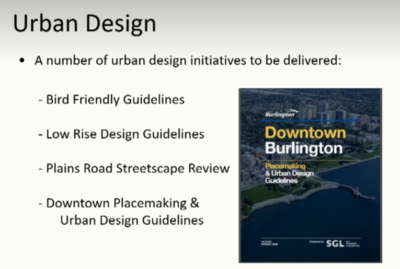 There are Guidelines for everything now. There is the Urban Design thinking, which Tellier described as “the glue” that keeps everything together.
There is a Pre-building permit process that is being put in place – this was intended for individuals who want to build a deck or install a swimming pool who don’t have the experience or skills to work their way through the way city hall works. The intention is to have a single person point of reference. This is covered by the Service Review Study that has taken place.
COVID has forced the city to find a better way of getting documents filed. Developers would come in with boxes and boxes of reports; now everything comes digitally.
 Jamie Tellier explains what is going to be built where on the Joseph Brant Hospital campus. Tellier explained that Planning has had to lean heavily on Information Services for both direction and support.
The Core Commitment is due for a serious review as well.
Tellier gave some insight into the complexity of the work to be done. Much of it involves liaising with legal, roads, transit, transportation and community planning.
In summing up, Tellier cheerfully said: That’s it!
Following all this is going to be a challenge.
By Pepper Parr
October 20th. 2020
BURLINGTON, ON
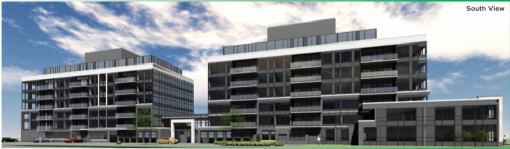
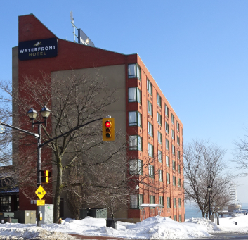 The owner of the hotel had plans to tear it down and rebuild closer to the edge of the lake One of the deeply concerning issues for almost everyone who lives in Burlington and spends some time each year at Spencer Smith Park is what is going to get built south of Lakeshore Road where the Waterfront Hotel is now located.
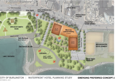 The Plan B people have been consistent and insistent that the public be at the table when decisions are made about how the Waterfront Hotel is to be re-developed. Council learned today that the Planning department has not been able to get consensus from the property owners which puts any work done on how the site is developed gets pushed back into 2021 for pthe creation of a work plan, and figuring out what the timing will be and what will be required in the way of budget.
This is a development area that has several sets of eyes on it – not just the planners.
Plan B, a small but very very effective group of people who have come up with an alternate set of plans that have not gone away despite precious little in the way of deserved attention from a former Director of Planning who left the city.
Related news stories:
Plan B people remind the city that they are watching what happens to the Waterfront Hotel site
Mary Lou Tanner – last paragraph in the story
By Pepper Parr
October 14th, 2020
BURLINGTON, ON
Every time the development at the top of Clearview Street in Aldershot comes up Ward 1 Councillor Kelvin Galbraith declares a conflict of interest.
His home is within the 120m distance from the development and he is seen as having a conflict.
Galbraith doesn’t have any problem with having to take this decision – he sees it as the right and proper thing to do.
 The Clearview development runs the length of the space between Clearview and St. Matthew. The Clearview development is contentious and has gone through a number of changes. Galbraith takes no part in the debate and does not vote on the matter.
 Kelvin Galbraith’s home is to the right of the tree trunk, one lot to the west, The Clearview development is at the top of the street where the think grey fence is located. Galbraith knew that when he was elected he would have conflicts. He chose to do the smart thing and meet with the City Solicitor before he was actually sworn, in we understand, to ask what the rules were and what was required of him as a Councillor.
Galbraith has property interests along Plains Road as well and will declare a conflict of interest should that property become part of a development issue.
 What we are seeing is a sterling example of how a Councillor should behave, which was certainly not the case with at least one member of the 2014-18 council. What we are seeing is a sterling example of how a Councillor should behave, which was certainly not the case with at least one member of the 2014-18 council.
During the September 30th Standing Committee meeting Mayor Marianne Meed Ward and Ward 2 Councillor Lisa Kearns put forward nine amendments to the Official Plan that was being debated.
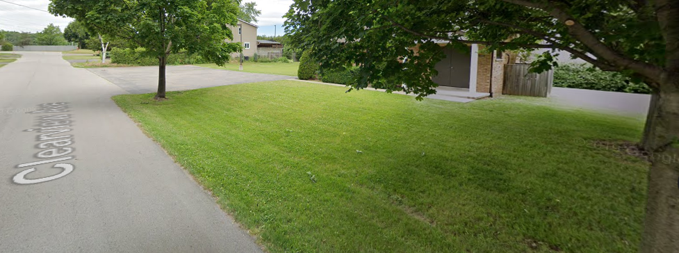
One of the amendments related to the Lions Club property that is bound by New Street, Maria, Martha and Elizabeth.
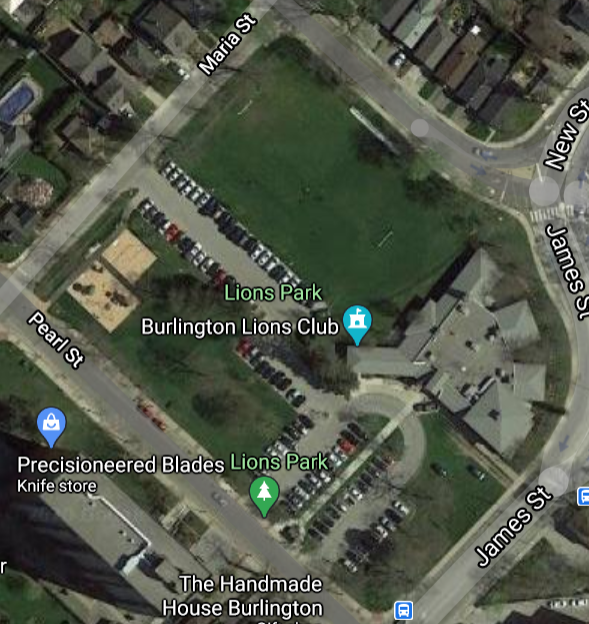 The Lions Park. The Mayor lives kitty corner from Maria Martha intersection centre top of the illustration, The Lions Club began buying up pieces of property in the 1920’s. The structure that is currently the Club House for the Lions and home to ROCK – Reach Out Centre for Kids also has space in the building which is due to have a second floor added.
While the land is owned by the Lions Club it operates as a city park and is maintained by the city.
The city also has a right of first refusal should the Lions Club choose to sell the northern portion of the property.
An interesting side note – the building on the southern part of the site was once the barn for the transit cars used by the Radial Railway that used to run along what is now Centennial Trail.
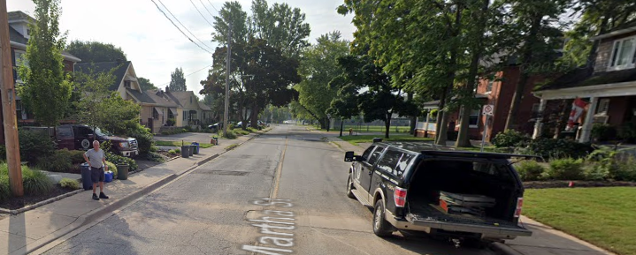 The Mayors home is approximately where the truck is parked in the driveway. The North East edge of the park is seen on the right hand side During the debate around how the property would be zoned the Lions delegated and said they would like to see the park zoning designation removed from the property. They felt that zoned as parkland lessened the value of the land should a time come when the Lions wanted to sell and the city chose not to be a buyer.
Living next to a park is usually a plus for a property owner.
The Mayor happens to be a property owner who lives kitty-corner to the park.
At no point during the debate did the Mayor declare a conflict of interest.
The Gazette sent a note to the City Clerk (Does the Mayor not have a conflict – she lives across the street?) asking if there was not a conflict.
The City Clerk sent back a note saying:
Please note that the our Members of Council are bound by the Municipal Conflict of Interest Act, R.S.O. 1990, c. M.50. In accordance with the Act, it is the duty of the member to disclose an interest. Staff does not provide comment or advice on whether a member may have a potential conflict under the Act. Section 28 of the Procedure By-law outlines the process that must be taken if a member has an interest that they disclose.
We don’t know if the Mayor has a conflict. Councillor Galbraith said he has a conflict and his house is as close to the Clearview development as the Mayor’s house is to the Lions park.
This is a question that the provincial Ombudsman can answer.
By Staff
October 14th, 2020
BURLINGTON, ON
The virtual Pre-consultation for the Molinaro development proposed for the Brant and Ghent intersection will take place this evening between 7 and 9:00 pm
 The development covers three of the four corners at Brant and Ghent. Instructions for Zoom Webinar
Participate On-Line via Zoom:
https://zoom.us/j/96657726680
Webinar ID: 966 5772 6680
By Pepper Parr
October 14th, 2020
 Grow Bold went out of favour. BURLINGTON, ON
A source in the city communications department told us that: “The logistical details of how we submit the OP to the Region are still to be confirmed.”
That document was passed at a Special Meeting of Council on October 6th.
Why the delay?
Perhaps a new design for the cover is in the works?
Related news story
Getting the plan to the Region
 By Pepper Parr By Pepper Parr
October 14th, 2020
BURLINGTON, ON
Just what DID Heather say during both the September 30th Standing Committee and the October 7th Council meeting?
Heather, being Executive Director Heather MacDonald who is also the Chief Planner for the city, was asked on multiple occasions if she supported the amendments made to the Official Plan late in the process of revisions being made to the OP that have been ongoing for more than a year.
 Mayor Marianne Meed Ward, standing in the Council Chamber during the singing of the national anthem. The amendment came out of the minds of the Mayor and ward 2 Councillor Lisa Kearns.
Each of the amendments was strenuously debated at the Standing Committee and done as a recorded vote at the Council meeting.
Specifics on those changes brought forward, and eventually passed at council, will be covered in a separate story – they are a little on the complex side.
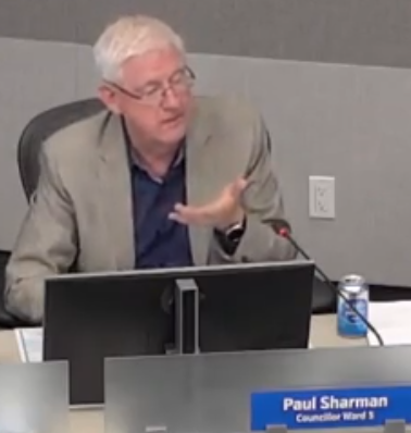 Councillor Sharman – a very deliberate questioner Councillor Sharman led the putting of the question to MacDonald on each item. “Do you support the amendment?”
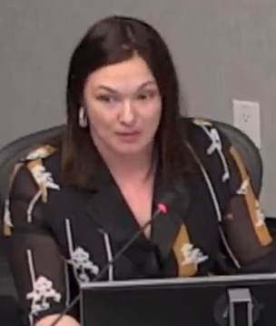
 Heather MacDonald, on the right with Alison Enns at a public meeting. During the first two amendments MacDonald was a little hesitant – not with her answer but in the way she expressed it. By the third amendment she had her answers formed in her mind and said consistently: “we gave council our best planning advice and are comfortable with what we did”.
She added later that she could not professionally support the amendments. While the consultant the city hired to advise, at a cost of $600,000 plus on a sole sourced contract, was not taking part in the meeting, Sharman asked if he was supportive and MacDonald said he was not.
MacDonald was put in a very awkward position. She and her staff had done a gargantuan job of ensuring that the recommendations put forward were solidly researched and based on defensible planning practices. The numerous studies done were there to support the decisions made.
 Ward 2 Councillor Lisa Kearns. Then the Mayor and Councillor Lisa Kearns, come forward with major changes – mostly to the east side of Brant Street. There was nothing inherently wrong with the changes – why didn’t they come from the planners?
Councillor Sharman concluded that when (he made a point of not saying if, but when) the plan is appealed to the Local Planning Act Tribunal (LPAT) the city will have to hire new planners because ours, Heather MacDonald, has already said she could not support the amendments.
Councillor Nisan took exception to the mention of hiring lawyers and added that this had already been covered; something that would have been done in one of the now infamous Closed Council Sessions.
This is high stakes stuff at a very professional level – it is the kind of thing one stakes their reputation on. One has to wonder if there was a meeting between MacDonald, city manager Tim Commisso and the Mayor at which MacDonald may have said that she could not support the amendments and would resign before they were passed by Council.
That would have put the fat in the fire.
The planners at every level did some fine work. The amendments took the bloom off the rose; they could have been discussed in detail before it got to the point where the Mayor was challenging the planners.
Meed Ward did say that she understood the position the planners had taken and added that the planners are in place to give council their best thinking.
She also said that Council has a moral and ethical responsibility to do what they believe is best for the city saying “this council is not a rubber stamp”.
There is now a state of tension between Council and the planning department that should not exist.
 Councillor Sharman 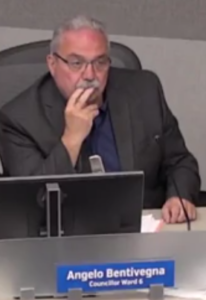 Councilor Bentivegna Councillor Galbraith The recorded votes, with one exception, were 4-3: Councillors Sharman, Bentivegna and Galbraith voted against the Mayor’s amendments and the other three siding with the Mayor.
Council Sharman pointed at that there are at least 23 appeals before LPAT – arguing those appeals are going to be a boondoggle for the planning and legal professions.
Salt with Pepper is the musings, reflections and opinions of the publisher of the Burlington Gazette, an online newspaper that was formed in 2010 and is a member of the National Newsmedia Council.
 By Pepper Parr By Pepper Parr
October 9th, 2020
BURLINGTON, ON
What happens now?
An 11 hour meeting to get through the Staff version of the Scoped ReExamination of the Adopted Official Plan and then debate the 9 amendments the Mayor and Ward 2 Councillor came up with – and it was then a done deal.
Well, as done as Burlington could do the document.
It has to be sent to the Regional government.
The document will fill a very very thick binder.
How do they get it to the Regional Planner?
 Entrance to the offices of the Regional government. By mid-October, staff will submit the Council-endorsed policy modifications for Downtown and Neighbourhood Centres, along with all supporting documentation, to Halton Region. Due to COVID, the logistics of submission are still to be confirmed.
How long will the Region need to determine if they can approve the document? Recall that they sent it back in the waning weeks of 2018 because it didn’t comply completely enough with the Regional Official Plan.
The Region will issue a draft decision on the City’s adopted Official Plan in November or December 2020.
How does it get returned to the city?
The Region’s Chief Planning Official will send the draft decision to Heather MacDonald, the City’s Executive Director of Community Planning, Regulation, and Mobility.
 City Council meeting – before COVID. Perhaps they could assemble in a live meeting to receive the xx from the Regional government. City Planning staff will then present the Region’s draft decision to City Council for review.
City Council will have a chance to review the draft decision and make comments before the Region issues a final decision.
Surely this will not take place at one of those wretched virtual meetings?
One of the issues for Burlington city council was – is the document appeal proof?
It is the Region’s decision that can be appealed, not the City’s.
After the Region issues a final decision on the City’s Official Plan, a Notice of Decision will be sent out to all parties who have participated in the Official Plan process by submitting written comments to the City or Region, or speaking at a public meeting.
The Notice will provide details about how to appeal the Region’s decision, and the deadline for filing an appeal.
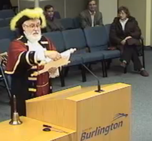 Town Crier David Vollick reading a message to Council. Anyone wanting to receive notice of the Region’s decision, should make a written request to Graham Milne, Regional Clerk, graham.milne@halton.ca, 905-825-6000, ext. 7110, Legislative & Planning Services, Region of Halton, 1151 Bronte Rd., Oakville, ON, L6M 3L1.
All very dry and dull.
Heather MacDonald might consider renting a small bus and driving to the Region where she and the staff she decides to take with her can don their face masks and troop into the Regional office bearing the flag with the city crest and the document in a leather binder carried on a dark velvet cushion.
The Town Crier could proceed this band of brave planners and announce that Burlington has arrived to deliver the Official Plan that city council has endorsed.
Somehow the Mayor will get herself on that bus – this is just too good a photo op to be missed.
By Pepper Parr
October 9th, 2020
BURLINGTON, ON
 Proposed 26 story structure on Brant, east side, north of Caroline.
Add another one to the downtown core.
This one is to be located on Brant, north of Caroline on the east side running from the Joe Dogs site north to where the Bank of Nova Scotia is located – at the south end of the No Frills Plaza.
Several blocks north – at Ghent and Brant the Molinaro development on either side of Brant will comprise of three 25 storey buildings that will cover three of the four corners of the intersection.
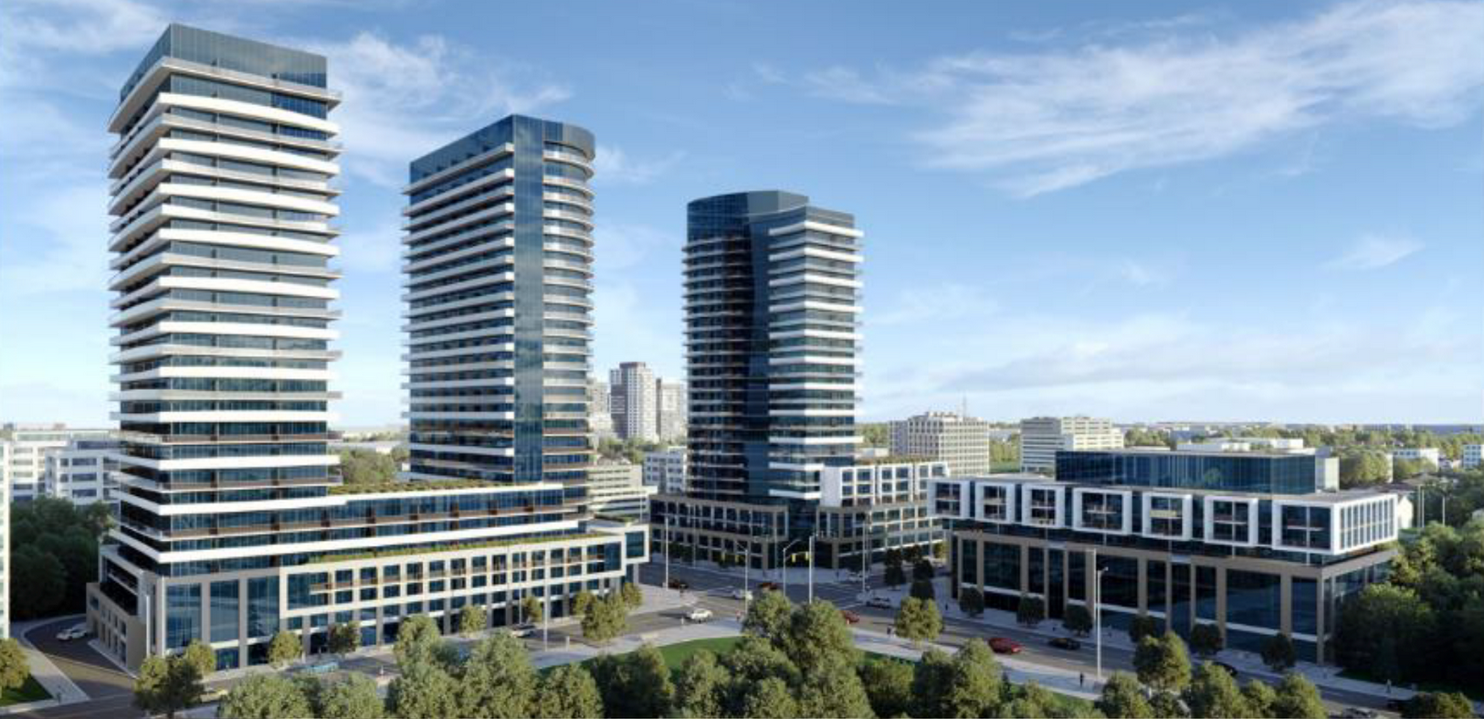 Three 25 storey structures.
And there is more to come.
The public will have an opportunity to comment on the plans for a 26 storey at a Pre-Application Public Meeting that will take place on October 26; it will be a virtual meeting.
The Zoom coordinates for the event are:
Participate On-Line via Zoom:
https://zoom.us/j/94629064953
(internet connection required)
Webinar ID: 946 2906 4953
- Participate by Telephone:
1-647-374-4685 (audio only)
The developers proposal at this point is for a
- 26-storey mixed-used building
- 248 residential units, including one, two and three bedroom units
Ground floor commercial space
Ward 2 Councillor Lisa Kearns may have a conflict of interest on this development, it is close to across the street from her residence.
Renimmob Properties Limited, based in Hamilton is the developer listed on the file.
 By Pepper Parr By Pepper Parr
October 7th, 2020
BURLINGTON, ON
At 10:26 am, Burlington city council approved their version of an Official Plan.
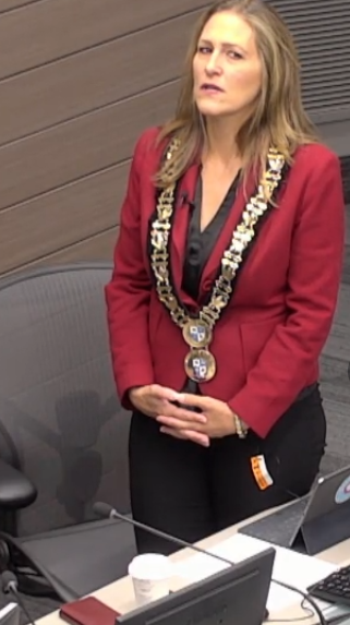
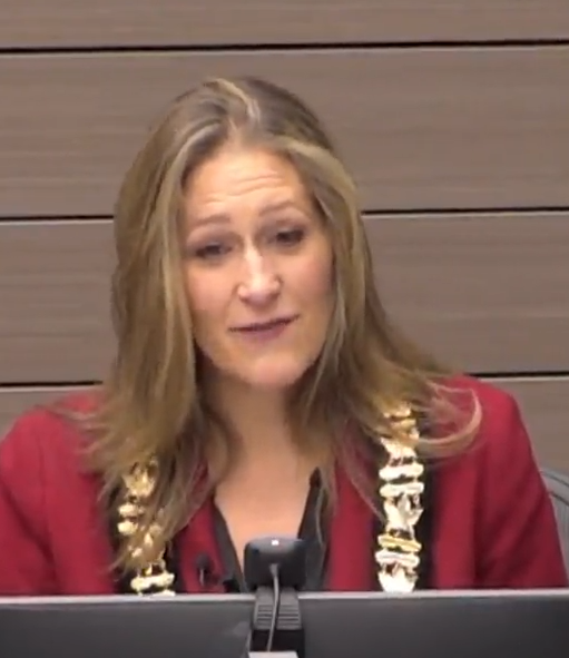 Mayor Meed Ward chairing an historic city council meeting – the day Council approved a new Official Plan. Did she break out the champagne? For Mayor Meed Ward it was a Hallelujah moment.
Ward 5 Councillor Paul Sharman did not vote for approval of the plan.
In her comments Meed Ward said: “This is a very pleasing moment.”
In 2018 the then Council approved and adopted a plan that would have permitted 30 high rise buildings in the down town core as well as a 117 storey tower in Village Square, said Meed Ward. She added that she was the only person to vote against that plan at the time.
 Marianne Meed Ward – Moments before being sworn into office. Shortly after the plan was approved by the 2014-18 Council Meed Ward got herself elected as Mayor with a significantly different council.
That council chose to do numerous studies that got them to where they are today which the Mayor said was a fully transparent process. The level of transparency is questionable – something we will detail in a separate article.
There were concerns about the nine amendments Meed Ward put on the table. She said this morning that Staff are in place to give Council their best thinking but that Council had a “more and ethical responsibility” to reflect the views of the people that voted them into office.
“Council is not a rubber stamp” she added.
It is a big day for this Council.
Only the future will tell if the right decisions were made – which is what politics is all about.
By Staff
October 7th, 2020
BURLINGTON, ON
This article is one of a series on the process the quarry application will go through.. Part 2 will be on what this will mean to the city and part 3 how the city will choose to tell the story.
Staff had been asked to prepare a report on the land use development application and review process related to the proposed Nelson Quarry expansion, including but not limited to the following:
• summary of the process including decision points;
• anticipated timeline for process steps;
• roles and responsibilities of review agencies;
• a summary of process and outcomes of the previous proposal for expansion; and
• a summary of any new provincial legislation related to aggregate resources.
And they did just that.
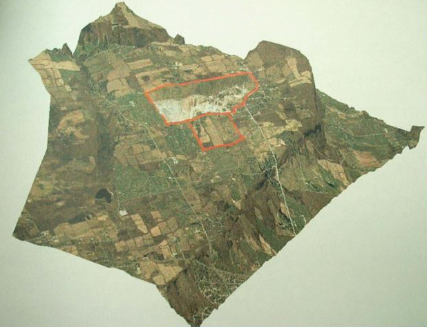 The site that was the focus of the first license application is shown in red. The topographical map shows the relationship to the geography of the Escarpment. On May 14, 2020, the City of Burlington received an application to amend the Official Plan designation of the subject lands to expand the existing quarry operation. Receipt of an application requires staff to assess it for completeness by ensuring all required technical studies and associated Terms of Reference, as identified during pre-consultation, have been submitted for review.
The Planning Act requires a determination of completeness within 30 days of the receipt of an application. However, in accordance with Bill 189, Planning Act timelines were suspended as of March 17, 2020, due to COVID-19. This suspension of timelines ended on June 22,2020, commencing the 30-day requirement. It is noted that that the need for additional studies or reports may arise as the application review progresses.
On July 20, 2020, the application to amend the City of Burlington Official Plan was deemed complete. The application is now formally accepted for review and processing. The application has been circulated to all applicable departments and agencies for review and comment. Public notice has also been issued indicating that the application has been received and deemed complete for processing.
The following studies have been submitted as part of the complete application:
• Agricultural Impact Assessment (prepared by MHBC, dated April 2020);
• Archaeological Assessment (Stages 1, 2 &3) for Lot 17 & 18, Concession 2 NDS, Former Township of Nelson (prepared by Archaeologix Inc., dated August 2003);
• Archaeological Assessment (Stage 4) (prepared by Archaeologix Inc., dated August 2004);
• Stage 2-1 Archaeological Assessment (prepared by Golder, dated March 23, 2020);
• Cultural Heritage Impact Assessment Report (prepared by MHBC, dated April 2020);
• Level 1 and Level 2 Natural Environment Technical Report (prepared by Savanta, dated April 2020);
• Financial Impact Study (prepared by Nelson Aggregates, dated April 2020);
• Air Quality Study (prepared by BCX Environmental Consulting, dated March 2020);
• Planning Justification Report (prepared by MHBC, dated April 2020);
• Progressive and Final Rehabilitation Monitoring Study (prepared by MHBC, dated April 2020);
• Traffic Report (prepared by Paradigm, dated February 2020);
• Level 1 and Level 2 Hydrogeological and Hydrological Impact Assessment Report (prepared by Earthfx, dated April 2020);
• Surface Water Assessment (prepared by Tatham Engineering, dated April 2020);
• Adaptive Management Plan (prepared by Earthfx, Savanta and Tatham Engineering, dated April 23, 2020);
• Noise Impact Assessment (prepared by HGC Engineering, dated April 22, 2020);
• Blasting Impact Analysis (prepared by Explotech, dated March 24, 2020);
• Visual Impact Assessment Report (prepared by MHBC, dated April 2020);
• Site Plan package (Drawing Nos. 1-4, including Existing Features, Operational Plan, Rehabilitation Plan and Cross Sections, prepared by MHBC, dated April 2020);
• Public Consultation Strategy (prepared by Project Advocacy, dated April 22, 2020); and,
• Karst investigations and conceptual model of the bedrock aquifer (prepared by Worthington Groundwater, dated April 25, 2020).
The lands subject to the proposed quarry expansion are located to the west of the existing licensed quarry, which currently contain the Burlington Springs Golf Club, and to the south, on lands which currently contain agricultural and residential uses.
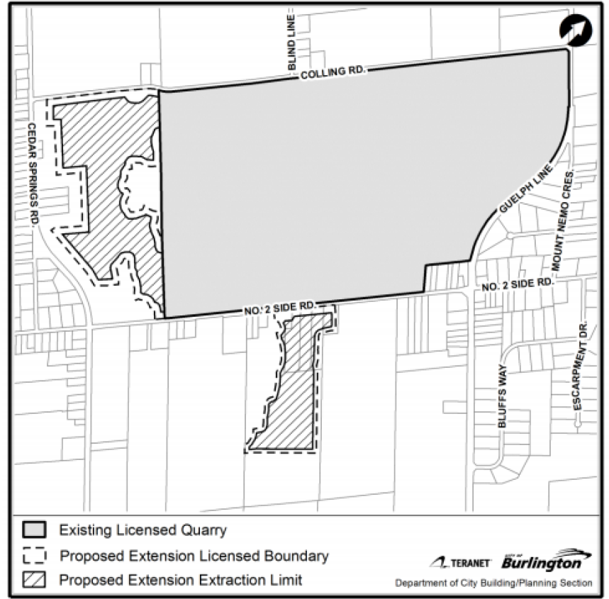 The shaded area is the land Nelson Aggregates wants a license to quarry. Review Process and Decision Points
Decisions on the proposed expansion to the quarry are regulated by the Niagara Escarpment Planning and Development Act, the Aggregate Resources Act, and the Planning Act. The following approvals are required to permit the quarry expansion:
1. Niagara Escarpment Plan Amendment and Development Permit;
2. Regional Official Plan Amendment to re-designate the proposed expansion land to permit mineral aggregate extraction;
3. City of Burlington Official Plan Amendment to re-designate the proposed expansion land to permit mineral aggregate extraction; and
4. Ministry of Natural Resources and Forestry issuance of an Aggregate License for the expansion area.
The applications to the Niagara Escarpment Commission, Region of Halton, City of Burlington, and Ministry of Natural Resources and Forestry (MNRF) have been received at the same time.
Given the overlap in technical review, it is common for such applications to be filed concurrently to ensure a coordinated review among all agencies. To ensure conformity with the most senior level of government, a sequencing of decisions is required.
The Niagara Escarpment Planning and Development Act stipulates that no approval or permission that relates to development (including aggregate extraction) shall be made within an area of development control unless a Niagara Escarpment Development Permit has been issued. A decision from the Niagara Escarpment Plan comes first in the process of reviewing and permitting mineral aggregate extraction proposals within the Niagara Escarpment Plan Area.
A decision on the proposed amendments to the Regional Official Plan and Burlington Official Plan cannot occur prior to approval of the Niagara Escarpment Plan Amendment and issuance of a Development Permit. Further to that, a decision to amend the Burlington Official Plan cannot occur prior to approval of the proposed amendment to the Region of Halton Official Plan.
It is noted that the MNRF cannot issue an aggregate license without an approval from the Niagara Escarpment Commission.
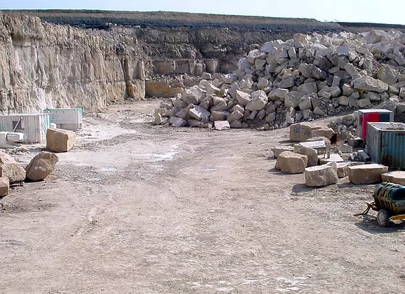 The current quarry is not yet completely mined out – but Nelson Aggregate knows that the site doesn’t have much time left. Public input related to the proposal is welcomed and encouraged. Prior to any decisions being made, public consultation will occur, including a statutory public meeting. The timing of the statutory public meeting has not yet been determined and will be scheduled once the technical review of the proposal has progressed further.
Best efforts will be made to align public consultation with the Niagara Escarpment Commission, Region of Halton, and City of Burlington.
A conceptual diagram, prepared by the Region, sets out the parallel review processes.
The proposed application is exceptionally complex, and the technical review has just begun. At this point it is difficult to outline anticipated timelines this early in the review process.
The sequencing of decisions from senior levels of government (i.e. Niagara Escarpment Commission and Region of Halton) will dictate the timing for a decision on the proposed Burlington Official Plan Amendment.
Both the NEC and the MNRF will be releasing requests for comment on the Environmental Registry of Ontario. This is anticipated to occur within Q3 of 2020, and the ability for the public, the City and other agencies to comment will be open for a limited period of time, as determined by the NEC and MNRF.
It is noted that the legislated timelines from the Planning Act with respect to the Region of Halton and City of Burlington Official Plan Amendments are applicable. Given the technical aspects of the application and sequencing of decisions to ensure conformity with senior levels of government, it is not possible to follow the procedures and timing of a typical development review process.
Regular reporting to council with progress updates will assist in providing clarity on timing as the review process unfolds.
Roles and Responsibilities
An inter-agency Joint Agency Review Team (JART) framework will be used to review the application for the proposed quarry expansion. The JART consists of technical staff from the municipalities and agencies (Niagara Escarpment Commission, Region of Halton, Conservation Halton, City of Burlington) reviewing the requested quarry expansion. The team is also supported by consultants with specialist skills. Halton Region is providing the coordinating role and administering JART for these applications.
It is noted that JART itself does not make a recommendation on whether or not the application should be approved. The function of JART is to review the completeness of the application and analyze the proposal on its technical merits. The JART framework ensures a coordinated review by all agencies. The consolidation of effort through JART minimizes duplication among reviewing agencies while ensuring a consistent and thorough agency response across technical disciplines. The JART framework is also intended to support effective communication with the public by providing information, receiving input, and coordinating a response to questions.
At the conclusion of the JART process, a report outlining the results of the joint technical review will be provided to the City to inform a recommendation report to Council.
The City of Burlington reviews the merits of the Official Plan Amendment application on an independent basis, taking into account the JART’s comments along with agency- specific considerations and public comments prior to making a recommendation.
Similarly, the Niagara Escarpment Commission, MNRF and Region of Halton are responsible for their own decisions on their respective applications.
Previous application to expand Nelson Quarry
A previous proposal for expansion to the Nelson Quarry was submitted in 2004. The Niagara Escarpment Commission, Halton Region, Conservation Halton, and the City of Burlington participated in the review of the 2004 proposal.
 The Jefferson salamander – it should be the city’s mascot. The applications for the 2004 proposal were referred to the Joint Board (consisting of the Ontario Municipal Board and Environmental Review Tribunal, formed under the authority of the Consolidated Hearings Act). The main issue with the proposal was the protection of Jefferson salamander habitat. In the decision, the Joint Board found that the proposal was not consistent with the purpose and objectives of the Niagara Escarpment Planning and Development Act and the Niagara Escarpment Plan and not consistent with the Provincial Policy Statement and refused the expansion.
It is noted that the current proposal encompasses a reduced portion of the lands from the 2004 proposal on the south side of No. 2 Sideroad and also adds a new/expanded phase of extraction to the west on the site of the Burlington Springs golf course.
New Legislation Related to Aggregate Resources
There have been recent proposals by the Province for new legislation related to aggregate resources through amendments to the Growth Plan and Aggregate Resources Act. They are summarized as follows:
1. Amendment 1 to the Growth Plan recommended, among other things, the removal of “habitat of endangered species and threatened species” as a consideration when permitting a new aggregate operation. Staff report PL-42-20 provided an overview to Council of this and all other proposed amendments to the Growth Plan. It is noted that at the conclusion of the public consultation process for Amendment 1 to the Growth Plan, the Province did not include this specific revision. “Habitat of endangered species and threatened species” remains as a consideration in the Growth Plan for a new aggregate operation.
2. Building on Bill 132, the Better for People, Smarter for Business Act, Ontario Regulation 244/97 made changes to the Aggregate Resources Act. The changes were based on the following themes: Ensure environmental protection, particularly related to water; Increase opportunities for community engagement on applications; Improve access to aggregates; and Reducing duplication and inefficiencies in the review/approval process. The proposed regulatory changes would apply to new pits and quarries, as well as existing pits and quarries. A staff memo in the May 21, 2020 Council Information Package provides a summary of the changes proposed by Ontario Regulation 244/97.
Communications Plan
On September 23, 2019, Council approved the following staff direction – Direct the City Manager to develop a detailed communications strategy to ensure the public is well briefed on the quarry process by May 2020.
As identified in this report, the Region of Halton will be taking a coordinating role on behalf of JART. Based on this approach, the Region has agreed to also take the lead on developing a communications plan for the Nelson Quarry application process. Discussions are well under way with City staff and Region staff on developing a plan.
The aim of the communications plan will be to ensure that affected residents and beyond are receiving up to date information on the application’s progress.
Communications will also go out to residents informing them about the opportunities to engage with the approving bodies to provide their feedback on any requests for comments.
Once the communications plan is developed by the Region of Halton, steps will be taken by the City’s Communications Department to amplify the information. These messages will ensure all residents living in Ward 3 are informed of the application’s progress. Residents from across the City will also be able to keep updated on the application by visiting the Nelson Quarry webpage, Burlington.ca/nelsonquarry.
Following Council approval of this report, there will be initial communications from the City about the high-level processes that has been identified in Appendix B.
 Ward 3 Councillor Rory Nisan; his ward is ground zero on the quarry question. Financial Matters:
The application fees to the City for an Official Plan Amendment is $82,220.00. All fees to date have been paid by the applicant. The applicant has been made aware, through the pre-consultation process, that peer review costs for technical reports are also required to be paid by the applicant, in accordance with the JART Protocol.
As identified above, a communications plan is being developed in partnership with the Region of Halton.
An application process timetable was prepared by the Region. The biggest concern for several Councillors was Q3 2022 – that is when the next municipal election is to take place and Councillor Nisan wondered what impact the issue of a quarry license extension might have on his being re-elected.
It is reported that Nisan has received more than 400 letters from people who want the quarry extension to be granted and that the city pay serious attention to the plans for turning the mined out quarry property into a huge public park.
By Pepper Parr
October 6th, 2020
BURLINGTON, ON
During the virtual public pre-consultation given by the ADI Development people last week the number of people who were “on the call” was small.
Two that mattered though were the ward Councillor, Kelvin Galbraith and Mayor Marianne Meed Ward.
 Kelvin Galbraith: ward 1 Councillor  Mayor Marianne Meed Ward They were there because council recently passed some rules for a process that, while voluntary, was necessary if the Planning department was to look at the application.
What was most interesting was how little they had to say.
One of the people who took part asked about retail and was told “there wasn’t going to be any”. There wasn’t a word of comment from the Councillor.
The ADI people said that base level retail was not considered. Judy Worsley, Executive Director of the Aldershot BIA said she had met with the ADI people and differed with them on ground level retail adding that “we will be revisiting this”.
 Rendering of a three story tower configuration. The ADI people agreed that retail was important and they saw that being built along Waterdown Road which could become a retail spine for the area.
Shawn Coon did say that if retail is found to work “ADI will be interested” adding that retail might not work right away.
One had to wonder at that point what the Councillor was going to do to get some traction behind the need for retail. The hundreds of people who are going to live at Station West will need groceries, a Beer Store, an LCBO at the least.
The word supermarket didn’t get mentioned.
Galbraith, who has been working with a developer nursing their project along in the area, has said the developer will include a coffee shop in his development. Galbraith is pushing him for a small supermarket that will be a long block away from the centre of Station West.
The matter of fire truck access came up which “needs to be worked out” according to Shane Cooney, an Executive vice president with ADI.
 Two towers at 39 stories each, a third at 29 storey. They will border Waterdown Road and Masonry Court. 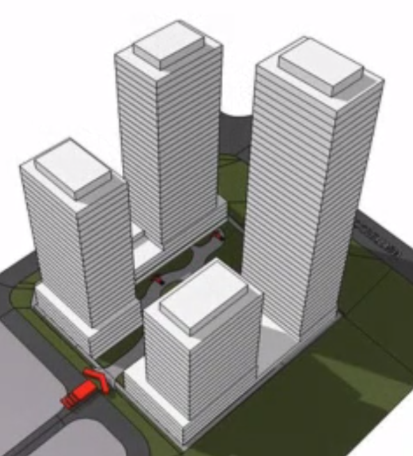 Height will range from 39 storeys to 18 storeys Meed Ward urged people to “continue thinking about what you like: green space, retail and built form.
Traffic was another issue: Cooney said that it is early in the process of doing a traffic impact study – we are not certain how to estimate what the vehicle traffic will be.
ADI defines Station West as a complete community with different housing forms.
There is certainly a lot of housing and in time there are going to be a lot of people in that community – but at this point there didn’t appear to be anyone talking loudly about what was missing. By the time half of the people have moved in it will be too late.
No library, no community centre, no park. Not the usual definition of complete community.
Related news story.
ADI gets to tell their story.
By Pepper Parr
October 5th, 2020
BURLINGTON, ON
The first of the Public presentations of a new development under the new rules took place last week.
The new rules require a developer to present their plans to the public and get feedback before taking their project to the Planning Department.
The rules are a little on the complex side and were the subject of some debate, which we cover in a separate article.
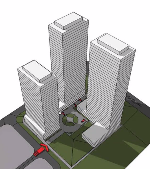
The presentation was done by the ADI Development Group and was focused on the second stage of their Station West development. The first stage is well underway – the developers said that there are already people moving in.
Something about that first phase – it is huge. Unless you drive north on Waterdown Road from Plains Road you might not see it. But drive north on Cooke or along Masonry Court and there it is – right in front of you. Cooke is extended right into the site of what amounts to six lengths of row housing.
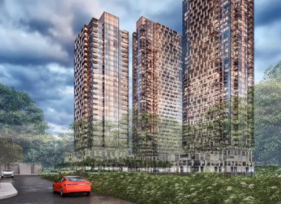
 The two structures are joined by a lobby area where the elevators are located. We weren’t able to determine just how many elevators there are.  This is the eastern boundary with the Aldershot GO station a short walk away. This is what intensification looks like.  Reasonably attractive, underground parking, basement units with a separate entrance – but it is still row housing with precious little in the way of grass. The meeting was to talk about phase two which is projected to be four towers (but it could be three) with heights of between 18 and 39 storeys.
What strikes anyone looking at the development is – where is the parkland?
 Architectural rendering of the the tower option for phase two of Station West. Where is there any retail?
Those questions didn’t get answered during the hour and a quarter virtual presentation.
More on that in a separate article.
The presentation itself was not all that bad.
There were three people who could be described as public taking part. That was probably because there was very little in the way of public notice.
The Gazette did a short piece two days before – not much time for people to read up on the development and prepare their questions.
The meeting was to get public input on phase two – the first phase is a done deal.
The developer was offering two versions: one with three towers, a second with four towers.
 Four towers with some green space in the middle. Height will run from 18 to 39 storeys.  Three towers with small park space in one corner. One tower at 29 storeys two at 39 storeys. The three tower option was made up of one 29 storey tower and two 39 storey towers.
The four tower option had buildings ranging from 39 storeys to 18 storeys.
There will be additional opportunities for public input. The truth is that there isn’t a community in place yet – there is no one to speak for the development and what it offers for those who see it as a place to live.
It is reasonably priced – said to be in the $700,000 range.
There are no homes in the immediate area that will be severely impacted by the high towers.
The development started when Rick Craven was Councillor for ward 1.
The land was reported to have been purchased from the Paletta interests for $14 million.
The ADI group has in the past built quality housing with some very innovative design.
Their Nautique in the downtown core is a smart looking 26 storey structure that has broken ground.
Getting to the point where they were able to start building meant breaking a lot of the rules; put another way – they were able to convince the then OMB that the little bus station on John Street was an MTSA – a transit area and that justified the height they were asking for.
The ADI’s are tough, very in your face developers. They don’t take prisoners – but they are in the process of creating a community that lacks severely in the way of amenities.
October 4th, 2020
Last week Council endorsed the recommendations from the Planning department on the Scoped Review of the Downtown Core portion of the adopted but not approved Official Plan.
The endorsement goes to Council this week and, if approved, will be come part of the Official Plan that is currently in the process of being revised. It will be sent to the Regional government where it has to be approved.
Citizens created an organization they called We Love Burlington, (WLB). That group released the following statement related to an article the Gazette wrote on the decision of Council to endorse what the planners had brought forward.
The WLB statement should be part of the public record.
Last December and January, WLB delegated before City Council opposing the direction proposed in the returned Official Plan for downtown development and the public waterfront. We were joined in our opposition by our colleague, Gary Scobie, long time civic activist and critic. Today we post a submission by two members of WLB and Gary on the virtually unchanged but ‘final’ direction for downtown and the waterfront. We continue to advocate for local voice and respectfully request that it be heard. If you agree, contact your Councillor and make your voice count. We strongly suggest looking carefully at the morass of documents and not simply the consultant’s Guidelines nor the summaries provided by the City or council members.
September 21, 2020
The following is the joint submission of Lynn Crosby and Blair Smith, two founding members of WeLoveBurlington, and Gary Scobie, long-time civic activist and advocate. We share a common passion for the City of Burlington and a common purpose in protecting its downtown and waterfront from inappropriate development and excessive intensification. We also have a compelling interest in preserving the integrity of local government – that level of governance closest to the citizen and most sensitive to local needs and voice. Indeed, WLB actually was created by the need to counter the provincial direction for amalgamation at the regional government level. The campaign, waged in concert by a number of ad hoc organizations, was ultimately successful and the threat of amalgamation in Halton removed.
Ironically, the government that WLB fought to preserve because of its perceived sympathy to the people’s will, then turned a virtual deaf ear to many of those citizens when it developed its revised plans for Burlington’s downtown. It would appear that proximity to the people is no guarantee of either the ability to hear their voice or follow their wishes.
On December 5th, 2019 and January 12th, 2020, we delegated before Council. On those occasions we questioned the timing and basic process of the course that brought forward the 243-page Integrated Control By-Law Land Use report and the highly interdependent 319-page Preliminary Preferred Concept Report. We challenged the timing, the conclusions and the basic sequencing of events. At that time, we urged Council to address the relocation of the Urban Growth Centre (UGC) and the mis-designation of the John Street bus station and the downtown as a Major Transit Station Area (MTSA). We argued that these actions must be a priority before any acceptable redesign of the downtown was possible. We asked for ‘no more tall buildings’. And we were not heard. Indeed, with our final delegations there was not one question posed. We raised inconvenient truths and there was no will to exchange ideas, no appetite to debate. We were politely but conclusively dismissed. We determined at that time that further delegation was pointless and the course for downtown irrevocably charted.
Today, however, we are making another statement in response to the latest documents, the Placemaking and Urban Design Guidelines and the Downtown Burlington Fiscal Impact Analysis and the latest, and apparently final, version of Report PL-16-20, Taking a Closer Look at the Downtown Recommended Modifications to the OP. We do this to bring orderly closure to our advocacy and, once again, echo the voice of Burlington citizens who deserve to be but have not been heard. Sadly, the situation remains almost exactly the same as it was nine months ago – all this time spent tinkering with the documents, but not substantially changing the position or the “vision.”
On page 8 of the Guidelines, for example, the two designations that enable both the Province and the development community to force high intensity massing of people and/or jobs in Burlington’s downtown remain unchanged and in force. We refer, of course, to the Urban Growth Centre (UGC) and the Major Transit Station Area (MTSA). COB recently announced that Council voted unanimously on August 24, 2020 to request removal of these designations, yet they remain the key component of the downtown OP, the Guidelines, all Schedules and the Fiscal Impact Analysis. Coupled with this is the fact that LPAT, the ‘new’ dispute forum, is a high-rise developer’s dream tribunal where height and massing in designated growth areas are not just supported but are actively encouraged.
The Urban Growth Centre (UGC) designation was first applied to our Downtown through the Places to Grow provincial legislation in 2005 and ratified by Burlington Council in fall 2006, just weeks before the City Election. It demanded a minimum 200 people/jobs per hectare over the area bounded by the Growth Centre and remains in place today.
The Major Transit Station Area designation arrived much later in the second decade of this century through the provincial agency, Metrolinx, based on the unsubstantiated claim that our Downtown Bus Terminal qualified as a Mobility Hub. The MTSA covers roughly the same area as the UGC and requires the same intensification minimums. Both designations support high intensity massing of people/jobs (and buildings) in the Downtown area and reinforce each other as provincial intensification tools. Moreover, both designations share three critical aspects detrimental to the popular “vision” of what constitutes “good planning” for Burlington’s downtown:
The intensification applies over an area, not a building.
There is no maximum stated. Only a minimum is demanded, and municipalities are “encouraged” to go above the minimum.
There is no mention in the legislation of maximum building height – the sky is quite literally the limit.
So, the two most damaging factors remain unchanged and will be ‘in force’ and operative for the foreseeable future – at minimum, until the Regional Official Plan is revised and approved. This factor alone undermines the comforting assurances and lofty principles of the Guidelines. Indeed, the latter are almost a misdirection, intended to appease a skeptical and fatigued citizenry; false guarantees that intensification can be controlled and made amenable to the public will. But, as Guidelines, they exist simply to articulate what “should be” not what “must be” and they can be contravened by any number of higher policies and direction statements. For example, the “Core Commitment: Downtown Vision and Action Plan” (as amended) goes beyond and takes precedence over the “Placemaking and Urban Design Guidelines”.
In essence, the Guidelines are unenforceable, part of an array of reports and documentation that requires a very informed and patient reader to do all the necessary cross-referencing to determine the complete context. As with the past process of last December and January, the documents are too numerous, too dense, too intricate and too complex. They are not intended to easily inform.
Truly, the devil can be in the details. There are instances in which the Guidelines don’t match or conform to the main OP report. One of the best examples is Village Square. The Guidelines talk about 4 storeys “abutting Martha Street” but Village Square, as popularly known, does not extend to Martha Street.
The Guidelines state:
“1. The maximum height of developments abutting Martha Street shall be 4 storeys and/or shall provide a built form transition to Martha Street and north of Pine Street to maintain the existing low-rise character.”
2. Retail frontages should be designed to complement and reinforce the unique human scaled and historic character of the Village Square Precinct.
3. Retail provided at-grade along Pine Street will act as a transaction to the Village Square development and emphasize an intimate relationship with the public realm by providing a minimum setback of 4 metres from the curb.
4. Development should maintain and enhance views of the Village Square.”
The language is intended to give the impression that the low-rise nature of the area is being protected and preserved. However, when the map (notably, only included in the revised schedules and omitted from the Guidelines) is referenced, it is clear that the north portion of Village Square allows 11 storeys. Moreover, both the Report and the Guidelines are silent on the treatment of the Square’s interior. At best this is misleading; at worst, a deliberate omission. And this is characteristic of the Guidelines as a whole. They contain a treasure trove of vague, ambiguous, qualitative language that provides a sense of affirmation but does not allow for measurement or objective validation.
The Guidelines perpetuate a number of known problems and deficiencies already cited with the planning process and the downtown modifications made to the Official Plan. Most glaring, perhaps, is the fact that the Old Lakeshore Road precinct continues to be ignored. Why is this most critical of precincts, the gateway to the downtown, continually out of scope?
Why are the serious issues, constraints and challenges posed not openly addressed? Why reference it as one of the 10 precincts and note that the downtown is “on a beautiful waterfront setting”, then completely ignore what is required to protect the waterfront, enhance its accessibility to the public and maintain the existing views? Indeed, Burlington has had a very uneven record over the last 20 years in terms of preserving and protecting the natural asset of the waterfront. It sold valuable waterfront property to private owners, failed to extend the waterfront trail and allowed development interests to prevail over those of public access. These Guidelines and this Official Plan do little to reverse the mistakes of the past. World class cities provide strict and enforceable measures to ensure that their waterfronts are valued as irreplaceable jewels and true public assets. Burlington, by contrast, posits a “feel good” set of principles (pp 44/45) factored around the discretionary preservation of “views” and “access”.
The same principles with the same poor expectation of effective implementation are used to preserve sight lines to landmark buildings such as City Hall, Knox Presbyterian Church and Village Square. One can reasonably argue that the view of City Hall will be obstructed by the Twin Towers approved for the northeast and southeast corners of Brant and James. Knox is located in the Downtown East Precinct that allows tall buildings and is vulnerable to demolition. Village Square presents a series of already identified issues. In fact, we take serious issue with the whole Downtown East Precinct in which the “precedent” of existing tall buildings is used to justify an ongoing ‘tall building’ development pattern. Why is the “precedent” not anchored in the many one or two storey houses in the area? How does the allowance for 17 storeys on Elizabeth Street and 17 at the Lions Club Park conform to the existing adjacent neighbourhoods? How does it conform to that which the people have been asking and how is it feasible that that small area around tiny Martha Street and Lakeshore/James could possibly accommodate this many tall buildings and additional congestion? Where is the requirement that Carriage Gate finally, after more than a decade, build their promised parking garage and medical centre at the site of their 17-storey condo building atop a three storey “podium” (the much-touted retail portion on ground level still completely vacant) located in the East Precinct? Why is the consultant/staff recommending 22 storeys at the Carriage Gate property at Pearl and Lakeshore, beside the uniformly unwanted ADI property next door?
There is almost a complete lack of green space and amenities. The map in Schedule 3, Appendix D shows three green circles denoting “public parks” (viz. Ghent/Brant, No Frills parking lot and Martha near New Street). They are small, located in insignificant areas and appear as afterthoughts – not integral components of the plan. The City claims to want to create complete communities with all of the amenities, but this worthy goal appears to have been abandoned in the downtown. Indeed, there is no section in the Guidelines dealing with green spaces and parks. Instead of needed amenities, community hubs and actual parkland, we are presented with the concept of POPS (Privately Owned Publicly Accessible Spaces) as leisure and recreational areas for the thousands of people who will populate the new buildings. The POPS were featured in the Fall 2019/Winter 2020 presentations of the preferred concepts for downtown. They were not critically acclaimed then and deserve no better treatment now. In fact, little has changed with either the concepts or the consultant’s treatment of the design for downtown. So, for example, where is the recognition that the pandemic has dramatically changed our reality? In the Fiscal Impact Analysis:
“Table 3-1 summarizes the residential growth projections for Downtown Burlington to 2031. It is anticipated that the within Downtown Burlington, the City’s population will grow by 2,787 population over the 2020-2031 forecast period. The population growth will be facilitated by the development of 1,720 additional high-density residential dwelling units. Consistent with the assumptions of the 2016 FIS, it is assumed that 75% of high-density residential development will be in the form of condominium development, with the remaining 25% comprising apartment developments.”
Remarkably, there is no updated view of the changes that COVID has made to our lives and the nature of our future living. Today, and for the foreseeable future, there is far less desire for condominium living and cloistered spaces. People want to distance and separate, want more open spaces and houses with traditional features and backyards. Accordingly, there should be fewer allowances for tall buildings and much better-defined planning for open spaces. Why is the consultant’s vision unchanged?
This speaks to our final major issue – the implicit cynicism of the consultation process and the lack of meaningful public engagement. Much has been made by the City and Council in ward newsletters and social media posts of the extensive outreach that has been undertaken. Citizens have been thanked for their time and effort reviewing an endless array of documents, helping to make the Official Plan and its policies a better, more inclusive work. However, nothing has materially changed. The preferred concepts, the vision and principles, the Official Plan itself with its myriad ancillary reports and the strategic documents ‘ad infinitum’ have not been varied or amended. The direction has not been moderated by either public comment and feedback or influenced by a differing public perception. The development scenario was essentially set during last Summer and Fall, when SGL Consulting was engaged under a directed tender to validate staff-defined outcomes. The necessary substantiating reports and studies were then concluded with predictable findings and the path forward unaltered from that framed and established at the very beginning.
Neither Council nor Planning staff should believe that a lack of new comments opposing much of these final documents means that the public now finds them acceptable. In the midst of a pandemic and at the end of a very long, quite protracted and overly tiresome process with too many documents, too many cross-references and too many versions, people are fatigued with the need for repetition; for saying repeatedly what they want and never being heard. We know that the council members are there to speak up on our behalf, convey our long-standing and unchanged positions, and to direct staff as they see fit. This is what the public expects and is counting on.
In summary, we’ve been here before – several times actually and nothing substantive has changed. It’s not that we expect that Council is under any obligation to passively comply simply because we attended and delegated. However, we did expect to be respected and to be heard. We represent a popular voice to which you have turned a deaf ear; worse, to which you have claimed an avid attention, then done nothing. We respectfully request that you provide for substantive amendments to the Official Plan, addressing the deficiencies noted in this submission and reflecting what the people of Burlington want for their downtown.
We understand that Council has worked with staff on modifications to produce a revised Official Plan for endorsement but we believe that it is seriously flawed. It leaves the waterfront vulnerable to development and permits a downtown in which tall buildings will dominate, with no real green space or public amenities. As we have said from the beginning, there is only one waterfront and one downtown – once gone there will be no bringing anything back and we urge the current Council, elected with such high popular expectation two years ago, to do everything needed to clearly ensure their permanent protection. Your legacy depends on it.
|
|